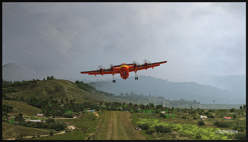
Today, rain and fog disrupt operations at Quebec City’s Jean Lesage International Airport. The conditions are at their minimum for take off and landing. But the captain of this Air Transat’s flight decides to proceed as the weather improves momentarily.
The passenger jet will take off from runway 06. But the airstrip is soaked. When the pilot applies power, we will only see water spray across the entire picture. A better choice is to focus on the A321neo as it taxis slowly.
Photography Tips
Since the sky isn’t particularly captivating due to its uniform gray colour, it becomes imperative to find something else to increase interest to the scene. The runway lights will do the trick. By including them in the foreground of the photo, they add life and frame the aircraft as it joins the runway.
I avoid photographing the plane directly from the side or from behind, as the effect is a bit static. Entering the runway at an angle offers a better alternative. Furthermore, it is not necessary to show the entire fuselage of the Airbus for a good shot.
With just a uniform gray sky, part of the aircraft, and a few runway lights, it becomes possible to produce a shot with more dynamism.
Click on the link for more aviation-related photos on my blog. There are also photo galleries for enthusiasts in the menu.
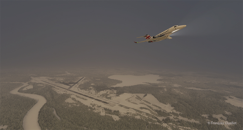
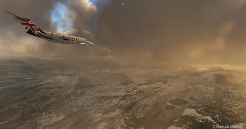
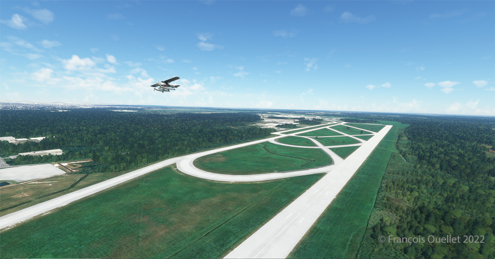
Airborne from the Ivalo virtual airport (EFIV) in northern Finland.
The fifth leg of this world tour in flight simulation continues with a journey from Ivalo airport (EFIV) in Finland to Molde airport (ENML) in southern Norway. It’s hard to see daylight through the cloud cover as we take off.
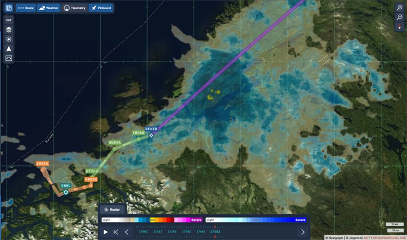
In anticipation of this and subsequent flights, I subscribed to Navigraph to make the experience even more immersive. The map below shows the choices for arrival procedures at Molde airport. In green are the reporting points for the arrival and in orange those for the approach. The aircraft follows these points automatically, thanks to the on-board computer.
Navigraph informations for the arrival in Molde (ENML)
I’m only just getting to grips with Navigraph and am still going through a trial-and-error process when it comes to using the data. But I’m making progress…
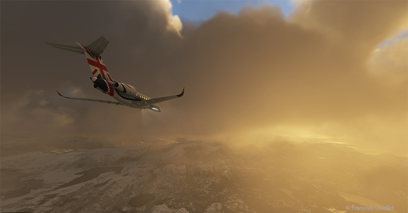
Heading towards the Molde (ENML) airport in Norway with MFS2020.
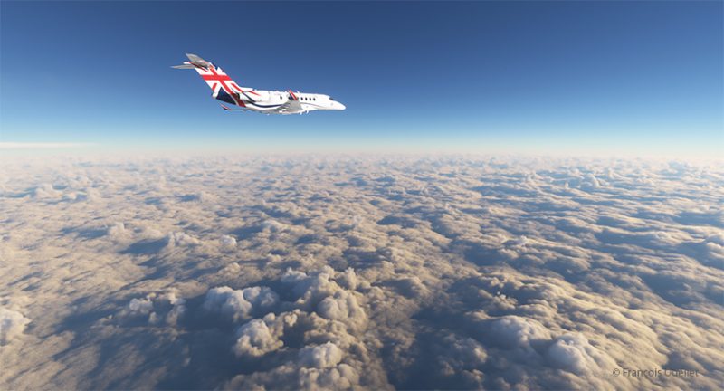
Once through the cloud layer, the aircraft finally reaches flight level FL380 (38,000 feet).
The runway at Molde airport is 2221 metres (7287 feet) long, and lies on the shore of Moldefjorden. It’s perfect for the Cessna Citation Longitude, but there are mountains on the approach.
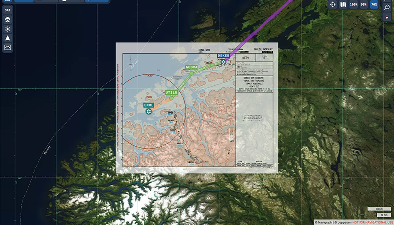
Navigraph map superposed on the geography on approach for the Molde airport (ENML)
The data provided by Navigraph helps the pilot to use the correct altitude limits to maintain a safe height above the terrain at all times. You can also track the aircraft’s progress along the chosen route. Several types of maps are also available to help prepare take-offs and landings. When required, maps can be overlaid with the Navigraph system, while maintaining the aircraft’s planned route over the local geography.
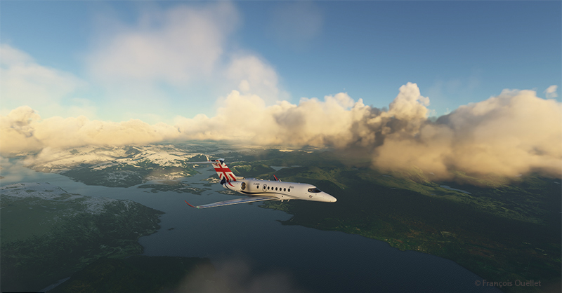
Cessna Citation Longitude descending towards the Molde airport (ENML) airport in Norway in flight simulation.
We start the descent to Molde airport. The cloud cover is relatively thin and visibility is not a problem.
Descending for Molde airport (ENML) in Norway with Microsoft Flight Simulator.
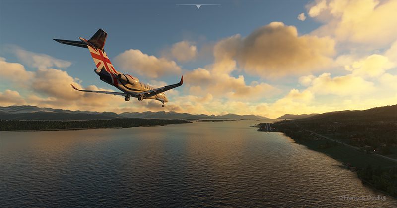
The setting sun makes for beautiful scenes on the descent to Molde.
Approaching the virtual Molde airport (ENML) with the Cessna Citation Longitude
Once out of the clouds and in ideal weather, the autopilot is disconnected and the approach is made visually.
On final for runway 25 at the Molde virtual airport (ENML) in flight simulation.
Winds oriented almost in line with runway 25 facilitate the approach.
Exiting runway 25 at the Molde airport (ENML) in Norway.
The Cessna Citation leaves runway 25 and parks for a few days in Molde, a Norwegian town renowned for its beautiful mountains and numerous parks and rose gardens. This town was saved from famine in 1740 by the presence of herrings. The town’s coat of arms features a whale hunting herrings in a barrel as a reminder of this period. Thanks to its position along the fjords and the foehn effect, winters in Molde are relatively mild (and very mild compared to Canada).
Soon the sixth leg of the flight will take place, from Molde to Sandane (ENSD), a Norwegian airport surrounded by beautiful mountains.
These machines, which were not designed to operate from an aircraft carrier, would not be able to reach their targets and return safely to port for lack of sufficient fuel. All the pilots were well aware of this, and volunteered.
The fleet of sixteen aircraft, commanded by Jimmy Doolittle, successfully achieved its objective of confusing the enemy and showing that Japan remained vulnerable to surprise attacks. The Japanese wondered how it was possible that American bombers could have reached and hit their country. Where did they take off from? They know that the B-25 Mitchells were not designed to take off from an aircraft carrier, and that they were incapable of landing on one.
The genius of the operation laid in the combination of a number of highly risky decisions which, taken together, took the enemy by surprise. Firstly, as it was impossible to land the planes on the Hornet, they were installed with a crane, knowing full well that they would never return to the ship.
In addition, the captains were trained to take off over distances unthinkable for them, using a technique pushed to the extreme. The ship sailed at high speed into the wind, improving the headwind component so essential for such perilous maneuvers.
The pilots had to be extremely skilful to keep to the departure trajectory on a platform that moved from left to right in the middle of a storm. Buildings on the Hornet’s side had to be avoided at all costs, and the available gap between the wing tip and the ship’s tower was no more than two meters. Despite all the obstacles, all the B-25s managed to take off. It was to be a one-way mission to Japan.
Doolittle piloted the first B-25 to take off from the carrier. He had only a very small portion of the deck to work with, as there were still fifteen other bombers waiting their turn to take off. The second pilot to leave the deck narrowly avoided a water landing, as the aircraft sank slightly and a landing gear wheel touched the water. But the plane gained just enough speed to stay airborne.
Bombers and crews suffered different fates once the bombing raids on Japanese targets had been completed. The authors conclude: “The raid destroyed 112 buildings and killed 87 people, in about 6 minutes. […] The destruction of 15 of the 16 B-25s, unable to reach Chinese airfields for landing, was nevertheless to be deplored, the 16th B-25 having landed safely in the USSR. Also to be deplored was the accidental death of three airmen (planes 3 and 6) and the capture of 8 others (planes 6 and 16) by the Japanese, 4 of whom never returned home, 3 having been executed as “war criminals” and the 4th having died in captivity. Worse still, the Japanese took revenge on the Chinese, who had helped all the surviving airmen, by organizing the massacre of some 250,000 civilians in the Zhejiang and Jiangxi provinces then under their control. This was to leave its mark…”.
Landing and takeoff tests on an aircraft carrier, the Forrestal, were also made decades later for a C-130 Hercules. I tried to repeat the experience in flight simulation. The flight can be found in the “challenging virtual flights” section of my blog. As the Forrestal is not available in virtual mode, I used the aircraft carrier USS Enterprise.
Decades ago, Canadian authorities used this island in the middle of the St. Lawrence River as a quarantine site for immigrants arriving in Canada. Many Irish people, among others, made an obligatory stop on this strip of land before being allowed to continue their journey to Canada.
At one time, a section of the island was reserved for Canadian and American researchers for their top secret research on Anthrax.The most amazing thing about reading the article is realizing that the entire production of this bacteriological weapon (439 liters) was mixed with formaldehyde and put in barrels that were dumped somewhere in the St. Lawrence River when it was decided that it would no longer be useful, as the Second World War took a turn in favor of the Allies. It seems to me that formaldehyde does not prevent barrels from rusting, but hey… back to the point.
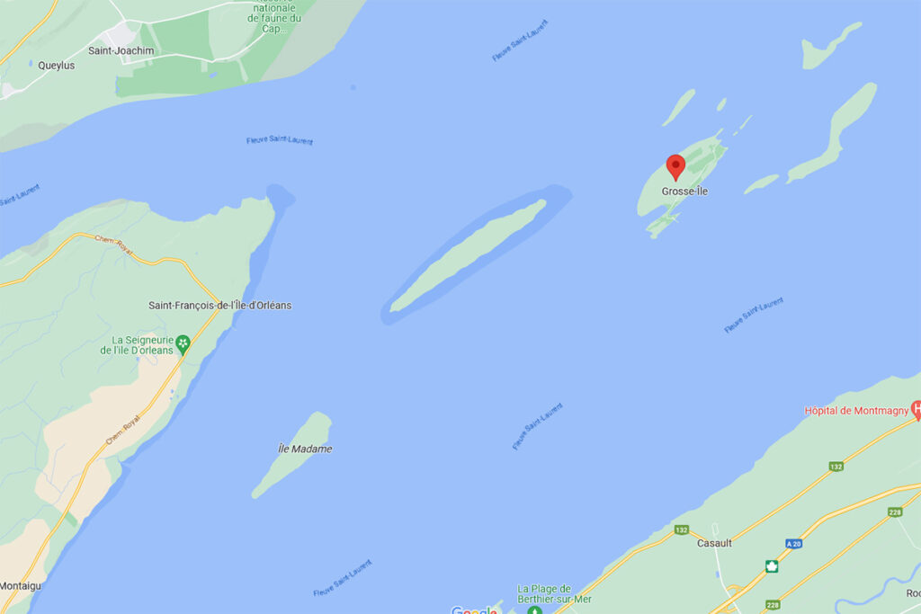
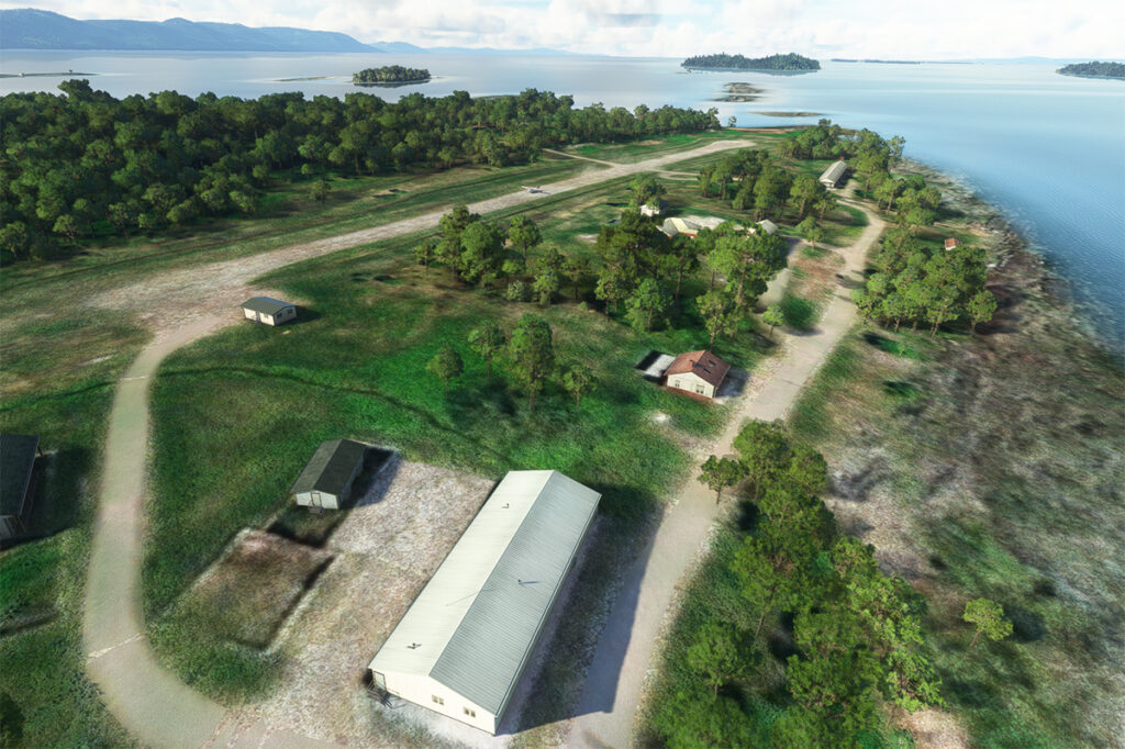
Where is Grosse-Île located? In the province of Quebec, a little east of Quebec City. It is one of the many islands that you can fly over once you have left Île d’Orléans behind. Below, a screenshot from Google Maps.
Grosse-Île in Quebec on Google Maps.
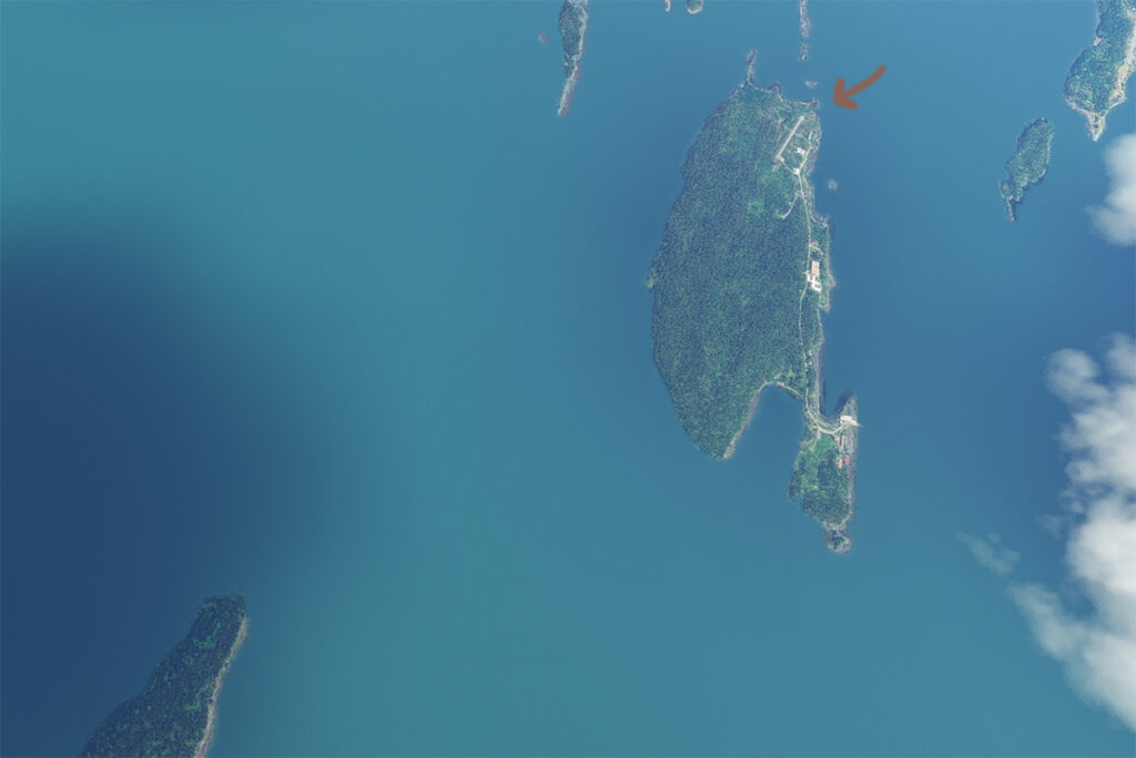
The satellite image below clearly shows that this is not an invention. Microsoft designates this runway as CYMN Montmagny: a mistake that one can easily live with, since by giving an official code to this Grosse-Île runway, the pilot can use it as a navigation point in his GPS.
Satellite view of Grosse-Île and its runway.
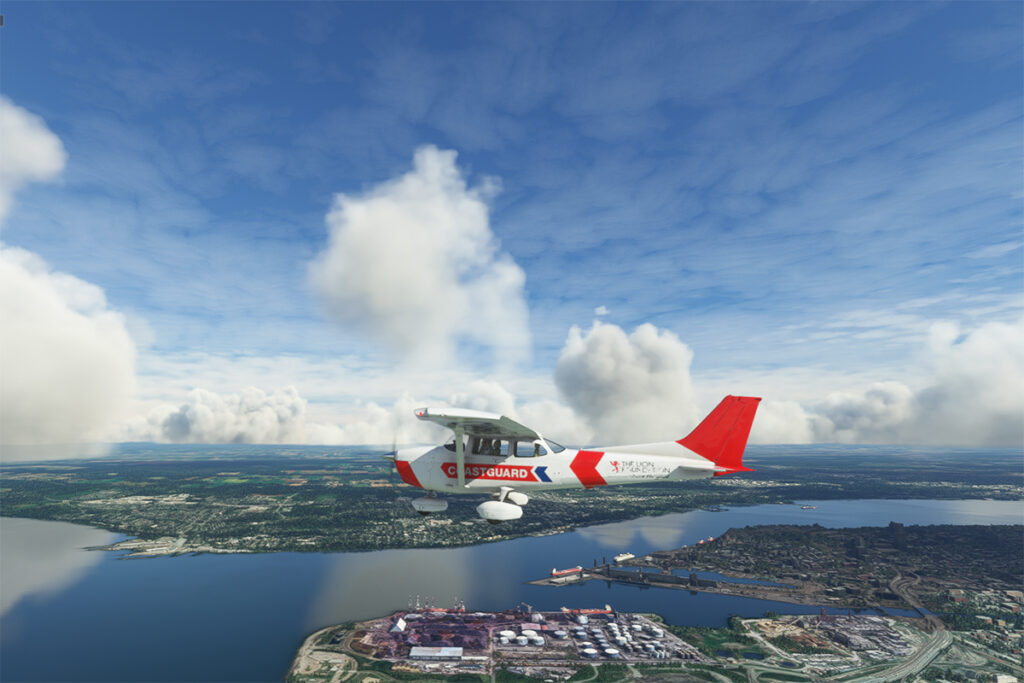
So, let’s use a small Cessna in US Coast Guard colors to make a virtual flight from Quebec City airport (CYQB) to Grosse-Île (CYMN). It was a bit chilly on this February day in Quebec City, so I decided to transport us to July for this flight, adding a few cumuliform clouds in the process.
Leaving Quebec City for Grosse-Île with MSFS 2020.
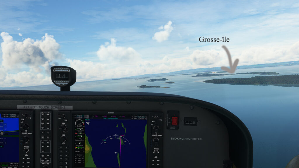
This short flight will allow us to fly over Île d’Orléans, Île Madame (owned by Laurent Beaudoin, former major shareholder of Bombardier), Île au Ruau (purchased in 2019 by the rich owner of the Gildan empire) to finally arrive at Grosse-Île.
Approaching Grosse-Île over the St Lawrence Seaway with the MSFS 2020 flight simulator.
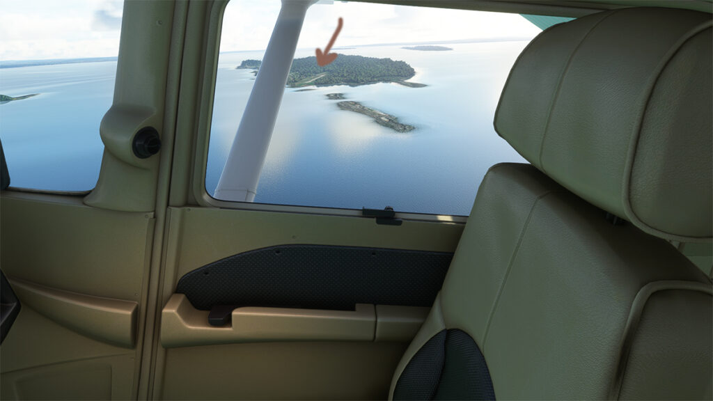
The picture below shows the aircraft on a right base for the Grosse-Île runway. I do not know the official dimensions of this dirt airstrip, but it can easily accept a Cessna aircraft such as ours.
Cessna in base for the Grosse-Île runway with the MSFS 2020 flight simulator.
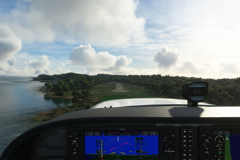
Below, the aircraft is on final for the runway.
On final for the Grosse-Île runway.
A final screenshot shows the Cessna taxiing down the runway after landing. As you can see, the runway can accommodate much larger aircraft. If you want to make a real flight to this island, find out beforehand about the condition of the runway and the restrictions surrounding its use by visiting pilots.
Cessna aircraft on Grosse-Île after the landing.
Click on the link for more flight simulation experiences on my blog.
Taking of from Rivière des Mille-Îles near Marina Venise
Today’s flight is part of my blog’s standard virtual flight category. The take-off is from the Mille-Îles River in Quebec. There will be a touch and go at Mirabel (CYMX) and a flight over Quebec and Ontario to the Cascades hydrobase (CTY3).
Towards the Mirabel international airport (CYMX) with the MSFS 2020 flight simulator.
Flying at low altitude towards Mirabel airport, for a touch and go.
The Mirabel (CYMX) runway is in sight.
One of the CYMX runways can be seen straight ahead. If a virtual pilot does not find the runway long enough to do a touch and go, then a refresher course is in order.
Touch and go at the Mirabel airport with MSFS 2020
Takeoff from Mirabel. This is the advantage of an amphibious aircraft; you can land anywhere.
The virtual weather shows the difference between the snow in the north and the green vegetation in the south.
The Lachute airport (CSE4) is visible (buildings in red in the foreground). Flying in April in Quebec allows to notice the demarcation between the still white landscapes (the snow persists) in the north and the areas where everything has already melted.
Over Hawksbury, Ontario, with the MSFS 2020 flight simulator.
The flight continues to the Cascades waterbase (CTY3). The Ottawa River separates Quebec from Ontario. The aircraft is currently over the town of , Ontario, with Hamilton Island on the left.
Realism of the flight simulation under MSFS 2020
The screenshot above shows the very realistic effect of the virtual landscape, both in terms of the virtual weather, the multiple color tones of the ground and the shading on the ground and on the aircraft caused by the breaks between the clouds.
Overflying the Plaisance National Park in Quebec with MSFS 2020
Descending for 1500 feet. Near Gatineau, the weather conditions deteriorate slightly. But it will be short-lived.
Turning towards the Gatineau river with the MSFS 2020 flight simulator.
Right turn for a water landing on the Gatineau River. The destination is in sight.
Water landing of the Gatineau river near the Wakefield hydrobase (CTY3)
The plane progresses slowly towards the hydrobase.
Aerial view of the Wakefield hydrobase (CTY3) with MSFS 2020
There is not yet a virtual waterbase worthy of the name for Cascades under Microsoft. At low altitude, the virtual pilot notes that he is only flying over a photo with aircraft footprints. An aerial view shows the CTY3 hydrobase.
Those who wish to repeat the experience will find the ride quite interesting.
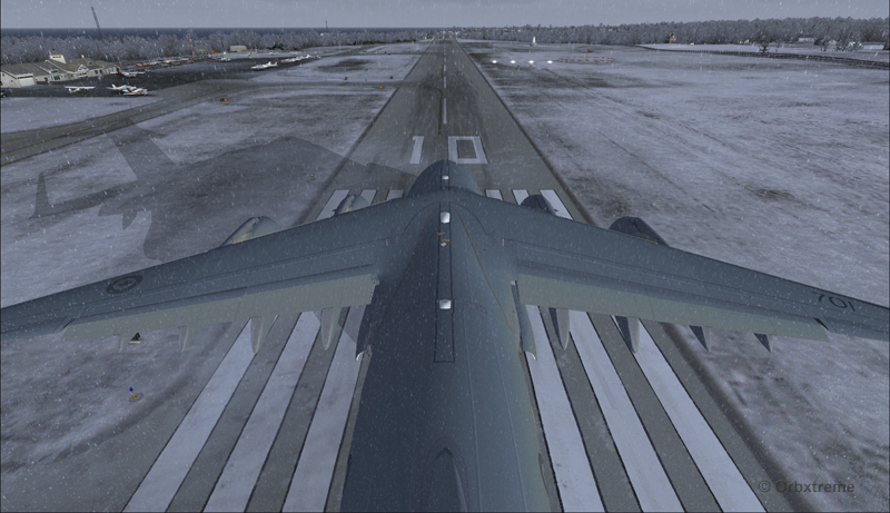
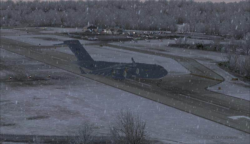
Alex Geoff, the ORBX Block Island (KBID) virtual airport designer, asked flight simulator enthousiasts to try to operate the biggest aircraft possible on that airport ‘s 2502 ft runway.
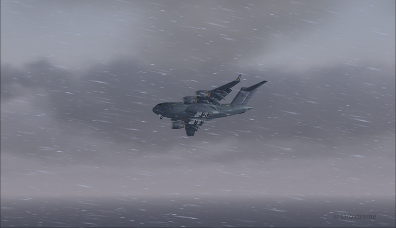
Canadian military aircraft C17-A ready for take-off runway 10 at the Block Island (KBID) virtual airport in United States (FSX)
Naturally, we are talking about a virtual flight. You must then forgive the landing of an aircraft which, in real life, would destroy the runway. You also have to disregard the fact that numerous trees would have to be chopped if the aircraft would elect to use the taxiway. I was almost forgetting the pilots and airport manager that would have to be fired following the authorized manoeuver.
The context of the flight having been presented, here is the data that will allow flight simulator enthousiasts to replicate the circuit around the Block Island airport with a Virtavia C-17A.
Contrary to the Cessna type aircrafts normally evolving around the airport, the total weight of the canadian military C-17A used for the flight was 405,000 pounds. The fuel was adjusted to 50% in all four tanks. Both pilots agreed to skip lunch in order to avoid adding any extra weight to the beast…
Flaps were adjusted to 2/3. I backed the aircraft to the beginning of the runway, applied the brakes, applied full throttle, waited for maximum regime, released the brakes and used ground effect to lift the aircraft before it was too late. The take-off was done on runway 10 with a 12 kts and 70 degree crosswind.
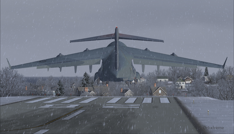
Canadian military aircraft C17-A airborne runway 10 at the Block Island (KBID) virtual airport in United States (FSX)
Then, four right turns were made : 190°, 280°, 010° and 100°. During the flight, the aircraft’s altitude never went above 2000 feet.
Canadian military aircraft C17-A turning downwind runway 10 at the Block Island (KBID) virtual airport in United States (FSX)
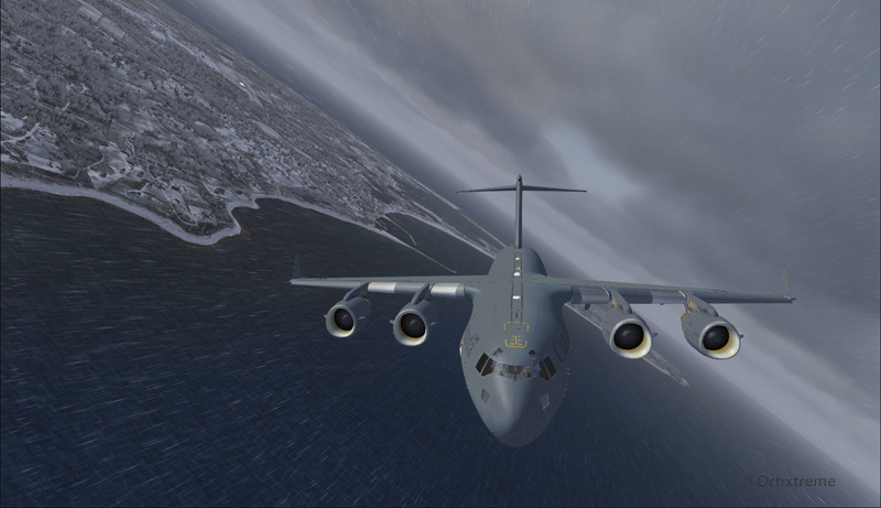
Wheels and flaps were brought down in base so that I did not have to make serious adjustments on final.
Canadian military aircraft C17-A turning base runway 10 at the Block Island (KBID) virtual airport in United States (FSX)
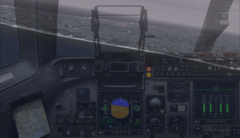
Canadian military aircraft C17-A on long final runway 10 at the Block Island (KBID) virtual airport in United States (FSX)
Canadian military aircraft C17-A short final runway 10 at the Block Island (KBID) virtual airport in United States (FSX)
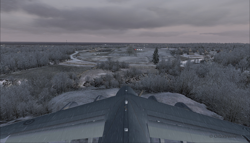
The speed eventually went down to 128 kts and, while the aircraft was still about two feet in the air, I used the airbrakes. The thrust reversers were fully activated two feet before touch-down (continued pressure on F2) since they take time to rev up. That is not necessarily the proper way to do it and you can wait one more second, until the wheels touch the runway, to use the reversers. The main gear touched at the very beginning of the runway and maximum breaking was then applied.
Canadian military aircraft C17-A landing at the Block Island (KBID) virtual airport in United States (FSX)
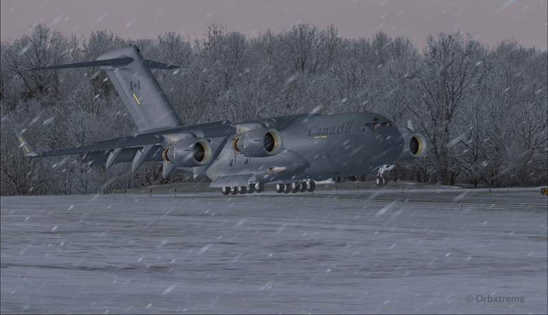
It was possible to exit on the taxiway without having to back-track on the runway. The environment always coming second, some trees were cut so that there were no contacts with the aircraft.
Canadian military aircraft C17-A exiting runway 10 at the Block Island (KBID) virtual airport (FSX) in United States
Canadian military aircraft C17-A taxiing at the Block Island (KBID) virtual airport (FSX) in United States
If you decide to try it out, think of saving the flight when you are on final, in case you are not satisfied with your performance during the landing (scrapped aircraft, destroyed houses and vehicles in the neighborhood, burned forest at the end of runway 10, collateral victims, etc.).
Canadian military aircraft C17-A at the Block Island (KBID) virtual airport (FSX) in United States
Good luck!
For other challenging virtual flights, head towards the flight simulation section of the present web site.
For more articles on flight simulation on my web site, click on the following link : Flight simulation
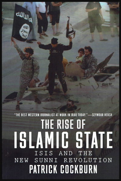
“Patrick Cockburn spotted the emergence of ISIS much earlier than anybody else and wrote about it with a depth of understanding that was in a league of its own.” – Press Gazette Journalist of the Year Judges
The book presents a bigger picture of what is happening in the Middle East than what we are normally allowed to watch in the news. The reader is presented with both sides of several stories and this really helps to get a better understanding of the different conflicts.
Cover of Patrick Cockburn’s book “The Rise of Islamic State”
Of lies and limited accuracy of the news
The author shows how lies are easily fabricated on a battlefield. He also explains the limited accuracy of news reports, such as when a “chosen” reporter is travelling, protected by an army or when reporters use second-hand information (often not verified) to prepare their news reports. It also seems pretty hard for a news channel to refuse to air a story when there are doubts about it, especially when all the competitors are reporting the same news.
I am including quotes (in italic) from the book as they provide excellent summaries. Some are from the author himself, others are from the sources he found to write his book. The author addresses so many subjects that it impossible to cover everything in a small review like the present one. So I’ll be as succinct as possible to present the reader with a broad idea of the book’s content.
Fear
Fear is the main factor behind many irrational political decisions. Fear leads to radical policies, religions and propaganda. It is often related to the fact that a very small group of people leading a country, a state or a region think that they can lose the political power that gives them undue privileges over the rest of their population. The greater the advantages, the greater the fear.
The political “solutions”, most of the time irrational, create tensions or aggravate the existing problems and only help to increase instability.
Saudi Arabia was initially helping ISIS because of fear of Jihadists operating within Saudi Arabia and fear of Shia powers abroad. As for Turkey, it is more afraid of the Kurds than it is of ISIS. So for a long period of time, it kept its border with Syria open: it helped ISIS to maintain a rear base.
The author says: “There is something hysterical and exaggerated about Saudi fear of Shia expansionism, since the Shia are powerful only in the handful of countries where they are in the majority or are a strong minority. Of fifty-seven Muslim countries, just four have a Shia majority” (p.102)
The demonization of religions other than Wahhabism
In the case of Saudi Arabia, the demonization of religions other than Wahhabism and the spreading of hate through social media have created a fertile ground for ISIS to grow.
The author says: “[…] The Saudis need a serious attempt to reform their educational system which currently demonizes Shias, Sufis, Christians, Jews and other sects and religions. They need to stop the preaching of hate from so many satellite stations, and not allow a free ride for their preachers of hate on the social media”.(p.107)
“The “Wahhabization” of mainstream Sunni Islam is one of the most dangerous development of our era” (p.108)
Money helps increase the polarization between Sunni and Shia
ISIS could not have risen without the financial help from Saudi Arabia, Qatar, United Arab Emirates and Turkey. Since ISIS thrives on tensions between Sunni and Shia, anything that increase that tension will benefit this terrorist group: “There is no doubt that well-financed Wahhabi propaganda has contributed to the deepening and increasingly violent struggle between Sunni and Shia” (p.99)
“A crucial feature in the rise of Wahhabism is the financial and political might of Saudi Arabia. Dr Allawi says that if, for example, a pious Muslim wants to found a seminary in Bangladesh, there are not many places he can obtain £20,000 other than from Saudi Arabia. But if the same person wants to oppose Wahhabism, then he will have “to fight with limited resources”” (p. 108)
“This polarization between the two religious groups was only intensified by the hot and cold war between the US and Russia. Proxies were at play here with Saudi Arabia and the Gulf monarchies, backed by the US, facing off against Iran, Syria, and Hezbollah in Lebanon, supported by Russia”(p.71)
Back cover of Patrick Cockburn’s book: “The Rise of Islamic State”
Propaganda that made al-Qaeda look stronger and more effective than it actually was, with reference to the 9/11 attacks
There are multiple sections in the book which relate to the September 11th 2001 attacks. Here are some of the author’s observations (in italic). I have also added some personal comments which are clearly identified as such:
The Pearl Harbour moment of the 9/11 attacks
The author says: “The shock of 9/11 provided a Pearl Harbor moment in the US when public revulsion and fear could be manipulated to implement a pre-existing neo-conservative agendaby targeting Saddam Hussein and invading Iraq”(p.100).
Note: the following four paragraphs are my personal comments on the “Pearl Harbor moment”:
A “Pearl Harbor” moment means that in order for the American public to approve an attack in a foreign country, it needed to see something terrible happening in the United States. For example, before the very obvious destruction of war ships at Pearl Harbor by the Japanese, the American population refused to be engaged in World War 2.
During the 9/11 attacks and later on, the Pentagon’s eighty cameras have not captured anything close to a Boeing hitting the building. You had to believe that it happened the way the news told you since there were no pictures and no videos of a Boeing close to or in pieces on the Pentagon property.
The Medias showed instead, over and over, the World Trade Center Twin Towers crashing to the ground after being hit by one aircraft, even though the buildings were built to resist multiple impacts, through a “mesh” design, a lesson learned after what happened on the Empire State Building years ago. Some people believed that the buildings crumbled due to the high temperature, but most neglected the FEMA’s report that got out later on stating that the temperature never rose above 300 or 400 degrees in the buildings, hundreds of degrees short from what was needed to melt steel.
The free-falling towers of the World Trade Center were the Pearl Harbor moment needed to instill fear and facilitate the implementation of a pre-existing neo-conservative agenda. The American voters would not have approved a war abroad if the buildings had been standing after a single impact. It’s almost like the world should believe that the World Trade Center was built using the poorest American engineering possible, while not learning from lessons of the past. For more info on this specific subject:
In 2001, al-Qaeda was an “ineffectual” organization
Mr Cockburn is one of very few reporters who is not afraid to present al-Qaeda as it really was in 2001, an emerging organization that was far from being able to mastermind and execute complex attacks such as the 9/11 attacks. (This also explains why, soon after the attacks, international news reports presented a video of Ben Laden denying responsibility for the attacks. A video that was not shown ever again. But millions of people saw it before it was censored by the main news channels).
“At the time of 9/11, al-Qaeda was a small, generally ineffectual organization” (p.59). The term “ineffectual” refers to the inability to produce a desired effect.
The implementation of the neo-conservative agenda
This really means that the pre-existing American neo-conservative agenda could not rely on Al-Qaeda’s experience. Instead, one or more experienced organizations were needed for the financing, planning and execution of the 9/11 attacks. Only after the facts could the blame be put on Al Qaeda since it was, after all the media propaganda, very well-known to the American public. An artificial link was then made with Iraq, allowing for an invasion that sixty percent of the American voters approved.
Sixty percent of the US voters were misled
“The name al-Qaeda has always been applied flexibly when identifying an enemy. In 2003 and 2004 in Iraq, as armed Iraqi opposition to the American and British-led occupation mounted, US officials attributed most attacks to Al-Qaeda, though many were carried out by nationalist and Baathist groups. Propaganda like this helped to persuade nearly 60 percent of US voters prior to the Iraq invasion that there was a connection between Saddam Hussein and those responsible for 9/11, despite the absence of any evidence for this. In Iraq itself, indeed throughout the entire Muslim world, these accusations have benefited al-Qaeda by exaggerating its role in the resistance to the US and British occupation” (p. 53).
The fall of Mosul
ISIS needed only 6000 fighters to win the Battle of Mosul. Yet, they were facing one million Iraqi soldiers. How was that possible? The author sees three reasons:
The cooperation from the Iraqi Sunnis, who were sensing that they would be better off with ISIS than the Shias.
Corruption at all levels in the Iraqi army. “As one former minister put it “the Iraqi government is an institutionalized kleptocracy”. Another politician who does not want to be named says “[…] People pay money to get into the army [so they can get a salary] – but they are investors not soldiers” (p.77)
The fact that the Iraqi army was no longer a national army since the well-trained Iraqi Sunni soldiers were sidelined.
Syria: President Bachar Assad was not as weak as expected
Both the outside world and opposition viewed President Assad as far weaker than he actually was. They both thought that he would be defeated without an organized air campaign.
A major oversight on the war in Syria
“A blind spot for the US and other Western powers has been their failure to see that by supporting the armed uprising in Syria, they would inevitably destabilize Iraq and provoke another round of its sectarian civil war” (p.73)
Five different conflicts within Syria
The Syrian conflict is extremely complicated since there are many different political and religious interests at stake: “The Syrian crisis comprises five different conflicts that cross-infect and exacerbate each other. The war commenced with a genuine popular revolt against a brutal and corrupt dictatorship, but it soon became intertwined between the Sunni against the Alawites, and that fed into the Shia-Sunni conflict in the region as a whole, with a standoff between the US, Saudi Arabia and the Sunni states on the one side, and Iran, Iraq and the Lebanese Shia on the other. In addition to this, there is a revived cold war between Moscow and the West, exacerbated by the conflict in Libya and more recently made even worse by the crisis in the Ukraine” (p.94)
In Syria, it is either Assad or ISIS
ISIS is the strongest opposition force in Syria. If Assad falls, ISIS takes his place: “Syrians have to choose between a violent dictatorship, in which the power is monopolized by the presidency and brutish security services, or an opposition that shoots children in the face for minor blasphemy and sends pictures of decapitated soldiers to the parents of their victims.” (p.81)
The God-given victories
“The appeal of the Islamic State to Sunni Muslims in Syria, Iraq, and across the world comes in part from a sense that its victories are God-given and inevitable, so any failure damages its claim to divine support” (p.159)
The solution to the Syrian conflict will come from outside the country
“Many Syrians now see the outcome of their civil war resting largely with the US, Russia, Saudi Arabia, and Iran. In this, they are probably right”.
Side notes
War is never about “combat” only. There is always an underlying political process going on. So, even if a country seems defeated militarily, enormous political efforts will have to be made in order to create a new stable order.
“Conviction that a toxic government is the root of all evil is the public position of most oppositions, but it is dangerous to trust one’s own propaganda”.
“A government or an army can try to maintain secrecy by banning reporters but they will pay the price as the vacuum of news is filled with information supplied by their enemies”.
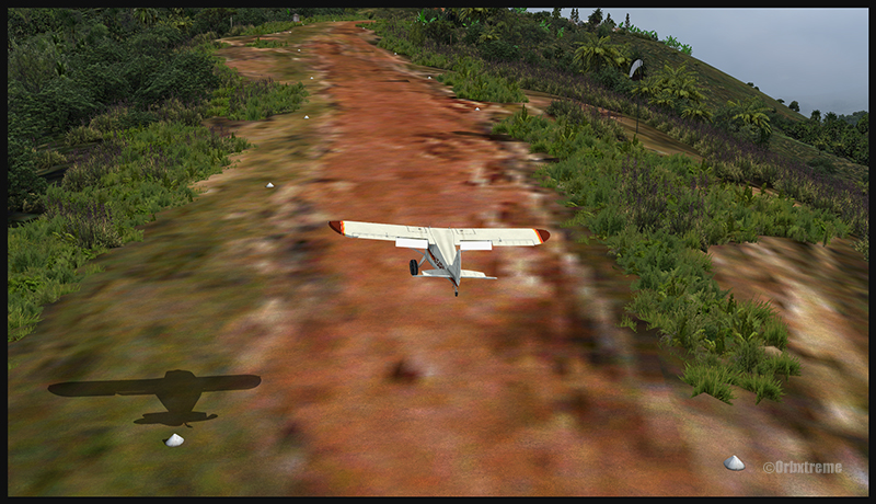
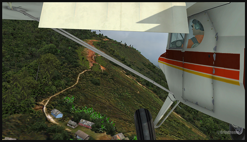
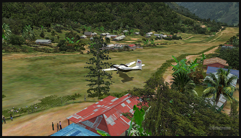
A virtual DHC-6 Twin Otter enroute for Kokoda after a fire on the right engine while departing Yongai (KGH) in Papua New Guinea PNG (FSX)
Ken Hall and Tim Harris have created a new virtual scenery for flight simulation enthousiasts. It is called “Tapini” and sold by ORBX. Their penultimate creation, AYPY Jackson’s International, allowed the virtual pilot to fly in very demanding virtual airports along the Kokoda Trail in Papua New Guinea. “Tapini” represents a whole new challenge and I have included several screen captures to show you how the different runways look in this new virtual scenery.
“Tapini”, still in Papua New Guinea, allows the virtual pilot to test his skills on seven new runways located in difficult areas of the Owen Stanley Range. Those airports also constitute a serious test for any aircraft, like in the picture above where damages to the right engine were sustained at Yongai.
A virtual Piper Pacer virtuel is about to land on the Ononge (ONB) curved runway in Papua New Guinea PNG (FSX). (It is possible to see the curve starting on the top of the image)
To improve the virtual clouds while flying between the different airports, I used either REX or FSGRW weather engines. The cloud textures and weather effects were improved by one or many of the following products: Cumulus X, PrecipitFX, REX Texture Direct and REX Soft Clouds.
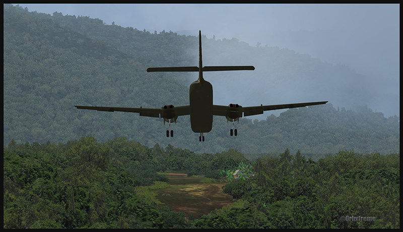
A virtual Dash 7 has just landed in Woitape (WTP) in Papua New Guinea PNG (FSX)
As variety is more fun, and also due to the different challenges created by those runways, the following virtual aircrafts were used: Carenado C-185F, Lionheart Creations PA-18, Virtavia DHC-4, Aerosoft DHC-6 Twin Otter and Milton Shupe DHC-7.
The “Tapini” scenery gives the pilot a choice between the seven following runways:
ASB (Asimba)
A tricky, very short runway near a river.
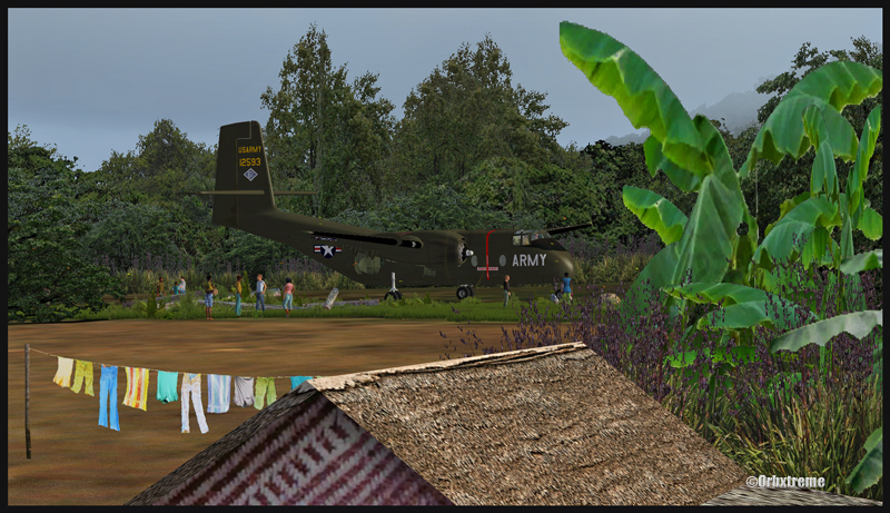
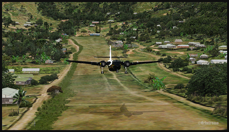
A DHC-4 Caribou virtual aircraft is on approach for Asimba’s sloped runway (ASB) in Papua New Guinea PNG (FSX)
This is a very interesting runway, best done with a STOL aircraft like the Caribou DHC-4. The inhabitants might have to help you clear out some branches along the runway, considering the size of the aircraft. The runway slopes down on take-off, which helps to build up speed.
A DHC-4 Caribou virtual aircraft is on a stopover at Asimba (ASB) in Papua New Guinea PNG (FSX)
A DHC-4 Caribou virtual aircraft is airborne from Asimba (ASB) in Papua New Guinea PNG (FSX)
FNE (Fane)
A one-way, really challenging 12 degree sloped runway, with unpredictable winds.
A De Havilland DHC-7 virtual aircraft on final for the Fane (FNE) airport’s sloped runway in Papua New Guinea PNG (FSX)
The runway sits on top of a hill. It is an amazing experience to land there. No wonder there are a lot of people watching the arrivals and departures.
If you slow down too quickly with an aircraft as big as the DHC-7 on that sloped runway, the twelve degree angle prevents you from moving forward. You must let the aircraft come down the runway very slowly, using the power to control the descent and the rudder to stay aligned on the runway, then apply take-off power for a few seconds to build just enough momentum to get above the hill.
A De Havilland DHC-7 virtual aircraft just finished taxiing uphill on the Fane (FNE) airport’s sloped runway in Papua New Guinea PNG (FSX)
To turn the aircraft around, it’s a combination of power and reverse thrust until you clear all the obstacles (any humans venturing behind the aircraft will also be cleared during the operation…).
A De Havilland DHC-7 virtual aircraft is airborne from the Fane (FNE) airport’s sloped runway in Papua New Guinea PNG (FSX)
There is a not so friendly man with a rifle watching the airport’s operations. Even the United Nations staff do not stay longer than necessary…
KGH (Yongai)
A very bumpy one-way sloped runway. A real bush aircraft is needed here!
A virtual DHC-6 Twin Otter on approach for the Yongai (KGH) bumpy runway in Papua New Guinea PNG (FSX)
Even with a real bush aircraft, there is a possibility that one of the aircraft’s propellers hits the ground while taxiing on the runway. There are so many deep holes that are hard to see, I can only wish the best of lucks to everyone trying out this airport!
A virtual DHC-6 Twin Otter on the Yongai (KGH) bumpy runway in Papua New Guinea PNG (FSX)
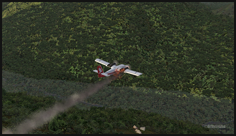
Keep a close watch on the area near the little house at the end of the runway. The DHC-6 was really shaken while turning around for take-off. One of the propellers hit the ground but no problems were detected…until the aircraft was airborne. The fire alarm then went off, just as the aircraft was passing the runway threshold, seconds before flying over a cliff.
A virtual DHC-6 Twin Otter with its right engine on fire is just airborne from the Yongai (KGH) bumpy runway in Papua New Guinea PNG (FSX)
So much for the planned trip… and it was out of the question to return to Yongai on one engine. I had to pull the handle to stop the fire, feather the prop, cut the fuel where it was not needed anymore then head to the Kokoda airport as it was a sure alternative, having a long runway and an elevation that did not require the use of extra power.
KSP (Kosipe)
A relatively short runway that requires good calculations from the pilot, since it is located high in the mountains.
A virtual Cessna C-185F is enroute to the Kosipe (KSP) airport in Papua New Guinea PNG (FSX)
The Cessna C-185F is a very well suited aircraft for that runway. Make sure not to be too heavy on the brakes, as new C-185 propellers are hard to find in Kosipe. You can land in both directions. Ensure that the mixture is set properly as the airport is above 6300 feet.
A virtual Cessna C-185F is rolling after touching down on the Kosipe (KSP) runway in Papua New Guinea PNG (FSX)
A virtual Cessna C-185F is airborne from the Kosipe (KSP) runway in Papua New Guinea PNG (FSX)
ONB (Ononge)
A curved and very bumpy runway! For those who like low flying. Make sure you choose the good aircraft here; there is not much manoeuvering area once on the ground.
A Virtual Piper Pacer on approach for the Ononge (ONB) curved runway in Papua New Guinea PNG (FSX)
Ononge looks really scary when you show up on final for the first time. You wonder if the little trail that you see can really be a runway. For that kind of situation, the little Piper Pacer is an excellent aircraft, approaching slowly and braking on a dime. The runway is curved in the middle so you will need a bit of right rudder to keep the aircraft aligned with the runway.
A Virtual Piper Pacer on the Ononge curved runway in Papua New Guinea PNG (FSX)
I guess all those people with their cargo are waiting for a bigger airplane than mine…
A Virtual Piper Pacer is airborne from the Ononge curved runway in Papua New Guinea PNG (FSX)
TAP (Tapini)
A challenging one-way sloped runway nestled in a tight valley. You can even use an ILS to arrive there!
A virtual DHC-4 Caribou on short final for the Tapini (TAP) sloped runway in Papua New Guinea PNG (FSX)
This is a superbly designed area and airport. I visited it with the DHC-4 Caribou but any other big STOL aircraft would have fitted there. There is enough room to manoeuver. It is not too bumpy. There is an interesting slope: it starts downward and ends upward: this helps to slow down the aircraft after landing.
A virtual DHC-4 Caribou on the ground at the Tapini (TAP) airport in Papua New Guinea PNG (FSX)
A virtual DHC-4 Caribou is airborne from the Tapini (TAP) airport in Papua New Guinea PNG (FSX)
WTP (Woitape)
Looks like a no brainer, but there is no margin of error on this one-way slightly sloped runway. Very precise calculations and settings are required if you want to land there with something else than a small aircraft.
A virtual De Havilland DHC-7 on final approach for the Woitape airport (WTP) virtual airport in Papua New Guinea (FSX)
I found the runway to be very slippery with the De Havilland DHC-7. I must say that there was a good crosswind, as I was flying with real life weather and winds. The DHC-7 behaves like a big boat while decelerating on such a runway.
A virtual De Havilland DHC-7 on the ground with two Twin Otters at the Woitape airport (WTP) in Papua New Guinea (FSX)
The Woitape scenery is gorgeous. It is nice to have all those well designed virtual aircrafts, people and animals on site as this makes the scenery so much more realistic.
A De Havilland Virtual DHC-7 is airborne from the Woitape airport (WTP) in Papua New Guinea (FSX)
I love this new Orbx product. When you fly in such a realistic scenery, the brain does not make much difference between what is real and what is virtual. It really works! And if you use real life weather downloaded from the internet, it’s even better.
I tried the seven airports included in the “Tapini” virtual scenery and they are quite demanding. Yongai was the most challenging airport of them all. I had to do two missed approaches there since I ended up too high on the approach. I eventually got it right, like in real life!
I used the Microsoft flight simulator X (FSX) for all the virtual flights, but other platforms would have worked as well (Dovetail Games FSX Steam edition (FSX: SE) and all versions of P3D). The following products were also installed on my flight simulator: FTX Global, FTX Global Vector and Holgermesh, as well as Pilot’s FS Global 2010.
It is a totally immersive virtual experience and you have to forget everything else when undertaking those challenging virtual flights… if you want to make it “virtually” alive!
For more articles on flight simulation on my web site, click on the following link : Flight simulation
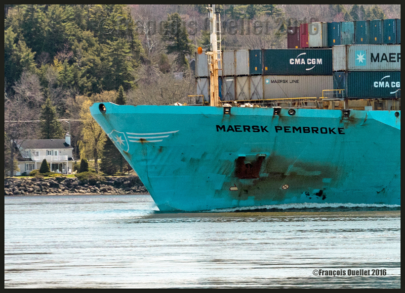
The container ship Maersk Pembroke under the Quebec Bridge, May 2016
Choosing what is important in a camera
Since there is actually no camera that has everything, whatever the brand, the buyer of a new camera must make choices: the type of sensor, the number of megapixels, the weight and size of the camera, the automatic focus’s speed and ability to follow a subject, the number of images per second, the performance under low light, the possibility to greatly enlarge a picture while maintaining its quality, advanced video functions, electronic communications with other devices, an extensive choice of lenses, etc. The list can be quite long…
The Canon 5DS(R): a specialized camera
A photographer happy with the Canon 5DS or 5DSR is one who needs a specialized camera offering both sharp images and the possibility of greatly enlarging the pictures it takes while maintaining the initial quality. This camera allows for more creativity as the possibility of extreme cropping beats, for now, everything that is on the market in the DSLR format.
Testing the potential of the Canon 5DSR when it comes to enlarging a picture
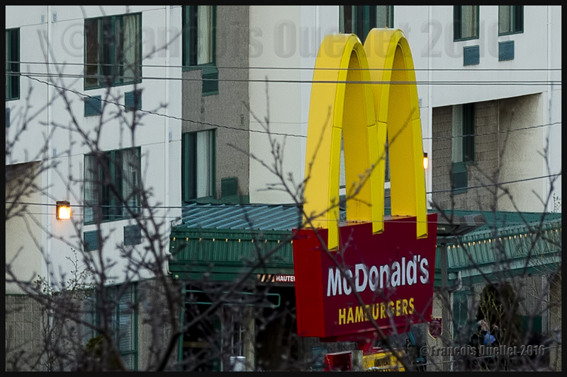
Here is an example of what this means: the photo below shows the yellow M of the McDonald’s restaurant photographed with a 50mm lens. Not easily visible…
Mc Donald’s restaurant’s yellow M captured with a 50 mm lens. Hard to see, of course!
Then the next photo was taken with a Canon EF 70-200mm f/2.8L IS II USM telephoto lens set at a 200mm focal length.
Testing the Canon 5DSR: the Mc Donald’s restaurant’s yellow M enlarged through a Canon EF 70-200mm f/2.8L IS II USM telephoto lens. Focal length used: 200mm.
But the picture can be enlarged a lot more using the amazing resolution of the Canon 5DSR. The following picture shows the result after cropping the 200mm image: the yellow M now takes the whole vertical space available in the picture without any loss in quality.
The Mc Donald’s restaurant’s yellow M, after having been enlarged (focal 200mm) and cropped within the Canon 5DSR.
From my position on the hill, the yellow M was barely visible with the naked eye. By using a 200mm focal length, followed by serious cropping, I was able to obtain the result above. So it is possible to photograph a subject that is almost invisible without a telephoto lens and transform it into the principal subject of the picture without any loss in quality.
I chose the 5DSR because the anti-aliasing filter has been neutralized in the model R to offer even sharper images, although there is a risk of occasional moire effect when there are repetitive patterns in a scene. This is the compromise that Nikon users must also have to deal with.
Rethinking photography
The 50.6 megapixel full frame sensor in the Canon 5DS or 5DSR allows a new approach of photography for those who do not have access to a much more expensive and larger medium format camera that does not necessarily give really superior pictures.
When I go outside for a photo session, it seems to me that I now carry a huge telephoto lens without the weight and the cost. A lot of what seemed to be unavailable possibilities are now accessible.
Taking pictures of people in the street is now less complicated: there are no more suspicious looks, artificial poses or people hiding their face. This is an ideal camera to capture people acting naturally without disrupting their routine. Gone is the feeling that you are bothering them in any way.
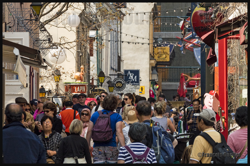
Quartier Petit-Champlain Old Quebec May 2016
The photo below was taken while I was standing at least 300 meters from the scene, just after sunset. For those who are from Quebec City, I positioned the tripod on a high wall on the other side of Chemin St-Louis, near the St. Louis Gate. I had to slightly brighten up the picture to make the details more visible, risking at the same time to increase the digital noise. It was a May 2016 warm misty evening, which is clearly visible by the lack of details in the background as we look in the distance.
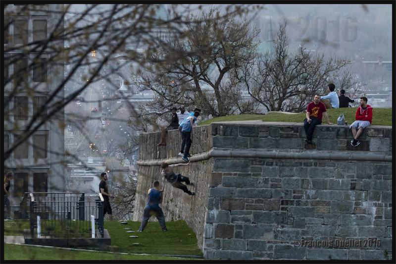
Quebecers defying gravity in Old Quebec, May 2016
But those are not the only possibilities of this camera. The Canon Company, in its promotional video, explains what exactly the camera was designed for:
How can someone maximize the use of a 50.6 megapixel full frame sensor
In order to bring a subject closer to you while fully benefiting from the Canon 5DSR 50.6 megapixel full frame sensor, it is obvious that there must be absolutely no vibrations. The photographer must therefore use a tripod, a remote control release and the mirror lock-up function. This allows for a very low ISO setting while avoiding a blurred picture.
The mirror lock-up function is very well thought through, with the possibility to choose a totally automatic processus according to a timing chosen by the photographer (between 0 and 2 seconds). The system eliminates any secondary micro vibrations.
In order to ensure an even better picture, the photographer must use Liveview and set it to the 16X enlargement available on that camera (versus 10X on my Canon 5D MKII) to manually adjust the focus. It is then possible to see the slightest vibrations caused by the wind. Doing so, I realized that my camera strap, lightly swaying in the wind, was causing some minimal vibrations. Every detail taken into consideration will improve the final result.
One must then ensure to immobilize the strap and even diminish the tripod height if possible when the wind is blowing. These steps will allow an incredible enlargement of a subject while maintaining the initial quality of the image offered by a full frame sensor.
Superior mirage effect (cold mirage)
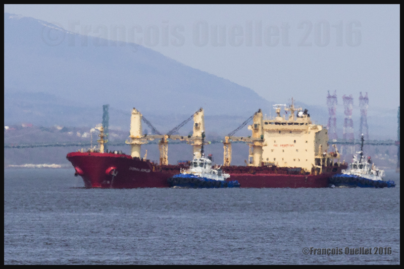
The photo below shows a ship being helped by two Ocean tugboats on its way towards the Quebec Harbour. The ship was at a good distance from the harbour; it is then possible to witness the superior mirage effect (cold mirage) resulting from a temperature inversion immediately over the water. The boats are deformed but the important close-up has not lowered the image quality. It has instead allowed to increase the atmospheric phenomenon effect.
Superior mirage (cold mirage) effect. Vessel and two Ocean tugboats on the St-Lawrence seaway heading to the Quebec Harbour, May 2016.
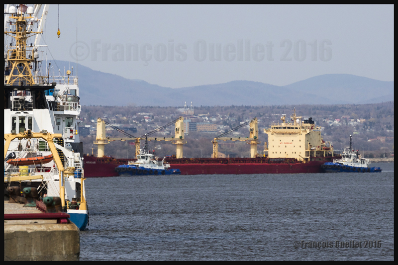
Once closer to the Quebec Harbour, the cold mirage effect decreased, as shown on the picture below:
Quebec Harbour, May 2016
The Canon 5DS or 5DSR without the use of a tripod or mirror-lock
Obviously, a tripod is not necessary if you do not intend to use a lot of cropping to enlarge a photo. You will obtain excellent results with the hand-held camera providing that you remember that this Canon DSLR is a specialized tool.
So many megapixels on a sensor of that size require that the photographer adapts his technique. But, as you can see from the picture below, it is totally possible to capture an aircraft in movement, even at dusk (May 11, 19:49), when the camera’s parameters are correctly adjusted. A higher shutter speed than normal is, in this case, absolutely mandatory.
The photo below shows an Air Canada Express Bombardier DHC-8-402NG (C-GSJZ) on final for runway 29 at the Quebec Jean-Lesage international airport (CYQB).
Bombardier DHC-8-Q-402NG (C-GSJZ — Air Canada Express) on final for the Quebec Jean-Lesage international airport, May 2016. Photo taken with a DSLR Canon 5DSR.
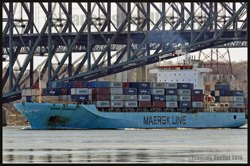
The Maersk Pembroke with the camera hand-held
The photo below shows the Maersk Pembroke container ship photographed with a hand-held camera using a Canon EF 70-200mm f/2.8L IS II USM telephoto lens during Spring 2016 near Quebec City. The focal length was only 140mm and the shutter speed 1/1000. The lens was equipped with a polarizing filter and the photo taken when the vessel was approaching the Quai des Cageux.
The Maersk Pembroke container ship on the St-Lawrence seaway near Quebec City, May 2016
The colours produced by the Canon 5DSR
The digital processing of the image and colours produced by the Canon 5DSR require different adjustments than what was necessary with the Canon 5D MKII. I am still learning how to handle the results produced by this camera so I will wait a bit before commenting.
View of Old Quebec from the St. Louis gate. Quebec City, May 2016
Night photography
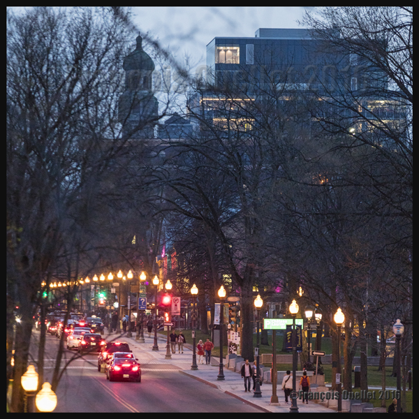
Here are two photos taken during the evening in Quebec City. The photo below required a 200mm focal, an ISO set at 4000 and a shutter speed at 1/30 in order to obtain something else than trailing lights. Luckily, the traffic was moving slowly…
Night photography, Grande-Allée avenue, Quebec City, May 2016
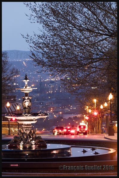
The picture below, taken with a 200 mm focal, required an exposure time a bit longer that one second with the ISO set at 800. To take the photo, I took advantage of the fact that the cars were momentarily stopped at a red light, so that they would be clearly visible.
Night photography, Tourny fountain and Quebec lower town, May 2016
The images per second of the Canon 5DS(R)
The Canon 5DSR is so far quite an impressive camera. I would have appreciated that Canon offer a higher rate of images per second (7 instead of 5) to make it more versatile.
The camera allows taking pictures with smaller formats than 50.6 MP, the two other options being 28 MP and 12 MP. If the camera can deliver five images per second with 50.6 MP RAW files, we can deduct that it is able to offer more speed for smaller formats. But the camera is blocked at 5 IMS so that it, I suppose, does not compete with other existing Canon models of the same category…
Nonetheless, Canon says that the rapid sequence of shooting lasts longer if the photographer uses the smaller files provided. So it is not faster, but it keeps on firing for a longer period. My guess is that it would only require a new firmware version to improve this camera’s number of images per second.
For other night pictures, click on the following link to my site:
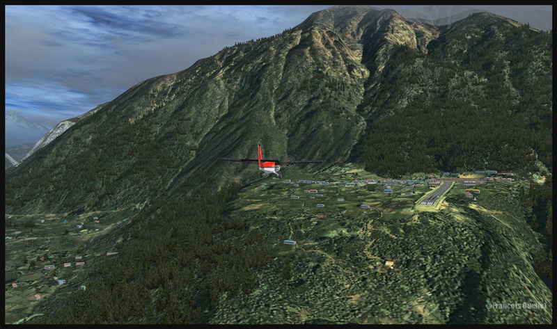
If you are looking for a challenging virtual flight, why don’t you try the route Syangboche –Lukla with the Aerosoft Twin Otter? It is a very short flight, few minutes only, where the aircraft will be constantly descending until its destination.
A Twin Otter aircraft is on descent from Syangboche towards the Lukla runway
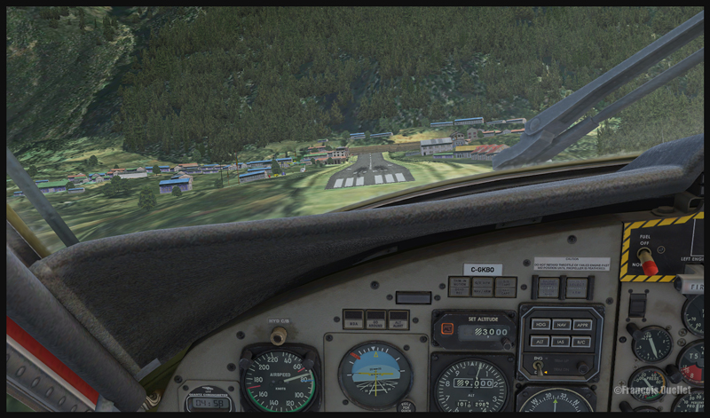
A Twin Otter aircraft is on approach for runway 06 at Lukla
The approach in Lukla can be tricky due to a 12 degree sloping runway. You have a feeling of coming in too quickly, but you must resist the temptation to reduce speed since, at this altitude, the stalling speed increases with all aircrafts.
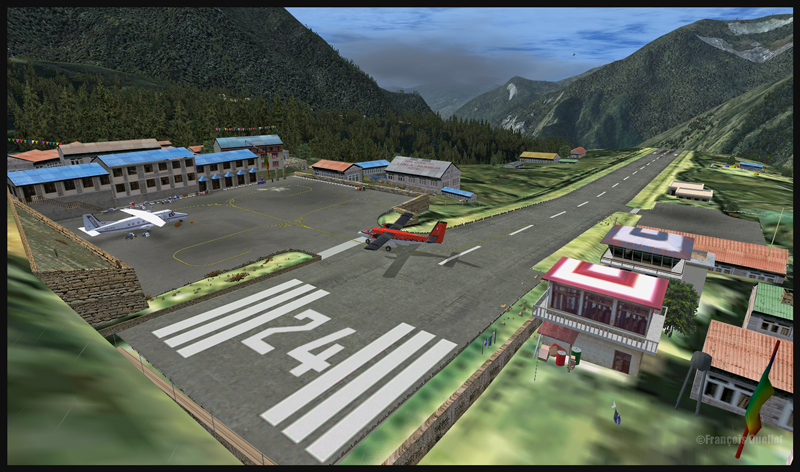
Runway 06 is used for landing, and 24 is for departures. There is no possibility of a missed approach. You either succeed or you crash since there is a high rock wall at the end of runway 06.
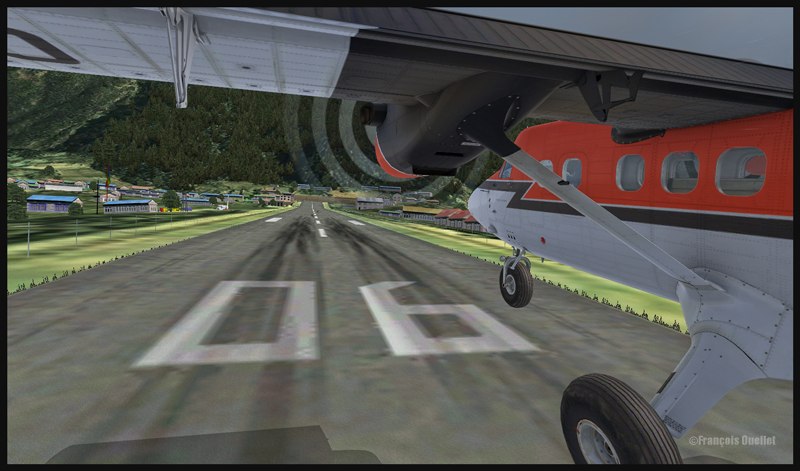
A Twin Otter aircraft is on final for runway 06 at Lukla
A Twin Otter is about to land on runway 06 in Lukla
So the flight is made from Syangboche (OACI code:VNSB, altitude : 3748m and a 400m runway) towards Lukla (OACI code:VNLK, altitude 2860m and a 460m runway).
A Twin Otter aircraft is landing on runway 06 in Lukla
The scenery and objects around Syangboche are a creation of ORBX. Once you get closer to Lukla, you will notice a change in the scenery details, since you are entering the Aerosoft Lukla scenery (you have to buy this additional scenery to make the flight more realistic).
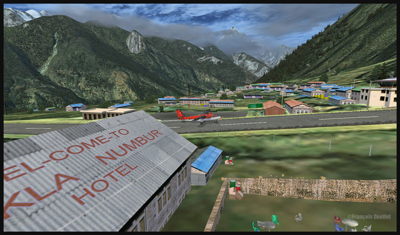
A Twin Otter aircraft has just landed on the runway at Lukla
A Twin Otter aircraft exits the runway in Lukla
The integration of the two scenery styles is very well achieved.
This flight will require all your attention. Good luck! For other challenging virtual flights, visit my website.
For more articles on flight simulation on my web site, click on the following link : Flight simulation