The graphic novel “Tsar Bomba” recounts, through the testimony of Andrei Sakharov, the competition between the major powers to create the most devastating atomic weapon.
The author Fabien Grolleau states that he does not wish to use his book for propaganda purposes, and I must say that I quite agree. Although the book focuses mainly on the USSR’s nuclear tests, it also provides information about France and the United States. When recounting the various stories that unfolded throughout the development of “Tsar Bomba,” it is essential to at least provide the reader with the context of the USSR at the time. We are dealing with a totalitarian regime that eliminates its own citizens, even if they have done nothing wrong. I saw the results of Stalin’s purges in the book “Les alpinistes de Staline.”
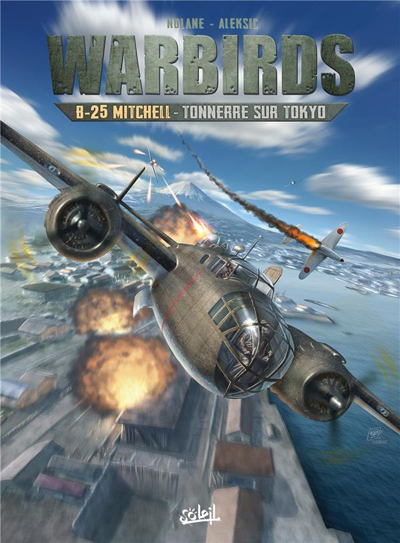
The graphic novel Tsar Bomba (in French)
Soviet scientists worked in what was known as “the Facility.” They did not know exactly where it was located, due to military secrecy. They did also ignore for how long they would work in these nuclear research laboratories. And it is clear that, given the context of the time, no scientist dared to openly criticize the Kremlin. But Sakharov was an exception.
Realizing the significance of his research, Andrei Sakharov began to “denounce Stalin’s crimes, the dangers of thermonuclear war, current and future ecological threats, and above all, the lack of democracy in his country! This was unheard of in the Soviet Union.” He had now become a dissident.
Below is a graph showing the difference in intensity between an atomic bomb created in 1945 and the Tsar Bomba of 1961.
Comparison of the strength of nuclear bombs
The Germany-Japan alliance during World War II upset the balance of power and pushed the United States to invent an unthinkable weapon to end the hostilities. The nuclear age began with the Manhattan Project and Hiroshima. The major powers recognized the devastating effect of atomic weapons and embarked on an arms race to establish a policy of nuclear deterrence. No single country could be allowed to possess the bomb! Humanity now had to come to terms with the idea that the balance of terror-maintained peace.
The author highlights the impact of radiation on residents living in areas surrounding nuclear test sites. Whether due to shifting winds, stronger-than-expected nuclear reactions, or a lack of transparency towards villagers, many citizens die as a result of these supposedly “controlled” tests. National security and territorial sovereignty take precedence over all other considerations.
On a Personal Note
A new race is now consuming all the energy of researchers working for the major powers: artificial intelligence. We hear about the ethical use of these technological advances, but this is more smoke and mirrors than anything else.
All that matters now for a major power is to ensure that it is ahead of the others. An article from the January/February edition of Foreign Affairs magazine mentioned that the country that has a real lead over its competitors in artificial intelligence will control the world. In this context, I do not believe that a major power will agree to limit itself and slow down its research because of an ethical issue.
In conclusion, here is a quote from Albert Einstein that appears in the graphic novel: “I don’t know how World War III will be fought, but I know how World War IV will be fought: with sticks and stones.”
These machines, which were not designed to operate from an aircraft carrier, would not be able to reach their targets and return safely to port for lack of sufficient fuel. All the pilots were well aware of this, and volunteered.
The fleet of sixteen aircraft, commanded by Jimmy Doolittle, successfully achieved its objective of confusing the enemy and showing that Japan remained vulnerable to surprise attacks. The Japanese wondered how it was possible that American bombers could have reached and hit their country. Where did they take off from? They know that the B-25 Mitchells were not designed to take off from an aircraft carrier, and that they were incapable of landing on one.
The genius of the operation laid in the combination of a number of highly risky decisions which, taken together, took the enemy by surprise. Firstly, as it was impossible to land the planes on the Hornet, they were installed with a crane, knowing full well that they would never return to the ship.
In addition, the captains were trained to take off over distances unthinkable for them, using a technique pushed to the extreme. The ship sailed at high speed into the wind, improving the headwind component so essential for such perilous maneuvers.
The pilots had to be extremely skilful to keep to the departure trajectory on a platform that moved from left to right in the middle of a storm. Buildings on the Hornet’s side had to be avoided at all costs, and the available gap between the wing tip and the ship’s tower was no more than two meters. Despite all the obstacles, all the B-25s managed to take off. It was to be a one-way mission to Japan.
Doolittle piloted the first B-25 to take off from the carrier. He had only a very small portion of the deck to work with, as there were still fifteen other bombers waiting their turn to take off. The second pilot to leave the deck narrowly avoided a water landing, as the aircraft sank slightly and a landing gear wheel touched the water. But the plane gained just enough speed to stay airborne.
Bombers and crews suffered different fates once the bombing raids on Japanese targets had been completed. The authors conclude: “The raid destroyed 112 buildings and killed 87 people, in about 6 minutes. […] The destruction of 15 of the 16 B-25s, unable to reach Chinese airfields for landing, was nevertheless to be deplored, the 16th B-25 having landed safely in the USSR. Also to be deplored was the accidental death of three airmen (planes 3 and 6) and the capture of 8 others (planes 6 and 16) by the Japanese, 4 of whom never returned home, 3 having been executed as “war criminals” and the 4th having died in captivity. Worse still, the Japanese took revenge on the Chinese, who had helped all the surviving airmen, by organizing the massacre of some 250,000 civilians in the Zhejiang and Jiangxi provinces then under their control. This was to leave its mark…”.
Landing and takeoff tests on an aircraft carrier, the Forrestal, were also made decades later for a C-130 Hercules. I tried to repeat the experience in flight simulation. The flight can be found in the “challenging virtual flights” section of my blog. As the Forrestal is not available in virtual mode, I used the aircraft carrier USS Enterprise.
Approaching the Narita international airport, in Japan, with Microsoft Flight Simulator 2020.
The Microsoft Flight Simulator 2020 is an extremely interesting product. Microsoft is taking advantage of the satellite imagery offered by Bing, which allows the flight simulation enthusiast to fly over the world almost like in the real life. With the addition of live weather and air traffic in real time, the immersion is incredible.
Flying over New York in the evening with Microsoft Flight Simulator 2020.
To download the game’s 128 gigabytes using my current internet plan, it took fourteen hours. I still remember when I bought a hard drive that could hold 30 megabytes of data: it was a computer revolution!
Of course, the game requires an adaptation. We are far from the old FSX platform. It goes without saying that you need a high-performance computer. But a new and very positive aspect of this simulator is that you can now use an X-Box controller as an in-flight camera, with the addition of a rudder and a steering wheel for more reality. This camera offers incredible possibilities and the additional X-Box controller becomes essential.
The Zlin Savage Cub flying over the United States using Microsoft Flight Simulator 2020.
As with anything new, there are some glitches. Personally, I have been using the CH company products for flight simulation for many years and the new MSFS 2020 has had problems recognizing the functions of CH products. Many virtual flight enthousiasts have had the same problems. So here are the links below that allowed a neophyte like me to solve the problems.
A first video of interest is also available. Its author uses a slightly different method, but it is super easy to understand and allows you to acquire additional knowledge if you want to map your CH rudder and control column correctly.
A second video gives you access to the CH company products. There you will find the links that allow you to print a representation of your CH flight controls. This will allow you to find which number is associated with a specific command control. You can then remap the controls to your taste and keep a record of all the modifications you made.
Here are two other practical links for answers to various questions about X-Box and other subjects and CH products.
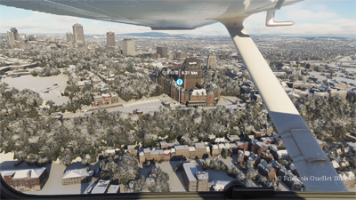
Aerial view of Quebec City using Microsoft Flight Simulator 2020.
In the screenshot above, you might recognize Quebec City, with the restaurant Le Concorde in the distance on the left, followed by the Edifice Marie-Guyart, a part of the Plains of Abraham, the Château Frontenac, the Price building and the lower town.
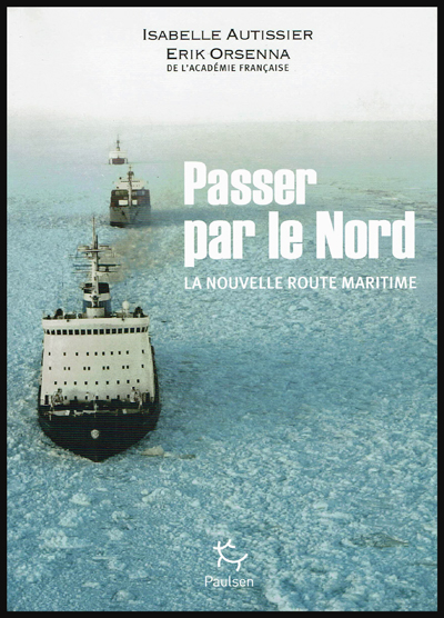
« Passer par le Nord » (Northern Sea Route), by Isabelle Autissier and Érik Orsenna, is an essential book for the reader who wishes to learn more about the profound transformations brought on by global warming, with regards to geopolitical, economic and ecological issues in the Arctic.
The book is at the same time a lesson in geography, history, politics, ecology and economy. It will certainly captivate those who are interested in maritime traffic and the development of new maritime routes, as well as the race towards the appropriation and exploitation of the immense oil and gas resources of the North.
Book cover of “Passer par le Nord” by Isabelle Autissier and Érik Orsenna
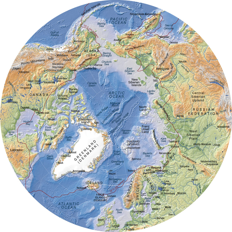
In order to sustain the reader’s interest, several maps are included in the book. They are very useful when comes the time to better understand the history and different uses, past and present, of the seas, islands and territories like: Kara Sea, Barents Sea, Laptev Sea, Franz Josef Land, Novaya Zemlya, Aleutian Islands, New Siberian Islands, North Land, Wrangel, Bering Strait, Svalbard, Spitzberg, Oslo, Tromsö, Kirkenes, Murmansk, etc.
Some of the seaways of Russia, which are among the longest in the world, are equally presented: Ob, Yenisei, Lena and Kolyma.
The numbers talk for themselves: to go from Rotterdam to Yokohama, a ship must travel 20,600 kilometers when passing through the Suez Canal. Only 12,800 kilometers are needed when using the northeast passage along the Siberian coast and 11,800 kilometers when traveling across the pole in the absence of ice during summer (this new transpolar route could be usable as soon as 2025). The need of resources by China and India, associated with melting ice in the poles, are rapidly taking Siberia out of its isolation.
Important people
The reader will certainly be interested by the information on the people who played a significant role in the discovery and exploitation of seas, islands and lands bordering the Northeast maritime route. Here are few of those names: the Viking Otar, Willem Barents, Simon Dejnev, Vitus Bering, Peter the Great, Alexander Baranov, Ivan Veniaminov, Adolf Erik Nordenskjöld, Ada Blackjack, etc.
The first northern crossing from the Atlantic to the Pacific belongs to a Swedish named Adolf Erik Nordenskjöld in 1879. Thirty-six years (1915) were needed to witness the second complete crossing, this time by Russian icebreakers under the command of Boris Vilkitski.
The importance of icebreakers
Icebreakers are extremely important for Russia, so much for protecting its recognized sovereignty and defending its new territorial claims than for economic reasons (insure the usability of the Northeast Passage and the continuous exploitation of the oil and gas resources along the Siberian coast).
The United States must also build icebreakers, so much for geopolitical and economic reasons than to insure the protection of a growing number of cruise ships that are about to use the narrow and risky channels of the Arctic.
An obvious collaboration exists between Russia and Norway with regards to fishing in the Barents Sea and in the south of Svalbard, a sector rapidly becoming more strategic with the northern migration of several fish species caused by the climatic changes. Ecosystems are nonetheless in danger due to the rapidly warming waters and insufficient time to adapt.
What are the obstacles presented by the Barents Sea towards tankers, ships and platforms? First the fog, which can last for weeks, than the “lows” which destroy vessels and twist superstructures. Finally,freezing spray adds excessive weight and freezes every crank on ships and platforms. In the event of an accident caused by oil or gas exploitation, the extreme meteorological conditions will present very important challenges.
One note on Siberia
The exploitation of mineral resources in Siberia was initially made possible, under Lenin, through work camps (gulags), since there were no volunteers ready to exile themselves in that hostile region.
The authors suggest, for whoever is interested in Siberia, the soon to be published book by Éric Hoesli. He has already published, in 2006, a very well documented book on the Caucasus: À la conquête du Caucase.
Oslo: Tschudi and Aker Solutions
The authors present two Norwegian companies based in Oslo which deal with logistics at sea: TSCHUDI and Aker Solutions.
Back cover of the book ” Passer par le Nord ” by Isabelle Autissier and Érik Orsenna
Shtokman and Yuzhno-Tambeyskoye natural gas reserves
The reader will certainly appreciate the chapter on the “eldorados glacés” (iced eldorados) which develops on the Shtockman and Yuzhno-Tambeyskoyenatural gas reserves fields (the latter holds 25% of the world reserve of natural gas). There are numerous challenges with regards to the exploitation of those fields: investments of twenty billion dollars, a necessary alliance between Russia, France (TOTAL) and China (CNPC), gigantic infrastructures to be built, the stabilization of all installations using thousands of posts, a constant fight against ice, the construction of thirty tankers (among them sixteen icebreakers), and the obligation to use the Northern maritime route.
Global warming
The book covers at length the accumulated effects of military, industrial and commercial activities on animal life and the environment. The fragility of the Arctic is well demonstrated. The reader will be surprised by the extent of nuclear wastes spread around the Novaya Zemlya.
The global warming favors the migration of species northward, an increase in the number of fishing vessels in the Arctic and political tensions between nations related to the ownership of the zone located between 12 and 200 miles along the different coasts. The native species are losing ground to the profit of the invasive species.
“[My translation] The diminishing polar ice will favor an increase in the number of ships in the Arctic with the added risk of collisions and the emission of all kind of noises that disrupt animals and prevent them from feeding correctly and communicate properly between them or with their offspring. Seismic tests or low-frequency sonars used by fishermen and militaries are particularly devastating.” (p.203)
“With few exceptions (Norway, Japan, Iceland), the moratorium on whale hunting is respected. The official predation by Inuit and the Russian poaching are limited.” (p.203)
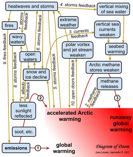
Map showing the links behind the accelerated warming of the Arctic (Source: http://arctic-news.blogspot.ca/2012/09/storm-enters-arctic-region.html)
Increase in extreme weather events
“[My translation] The diminishing pack ice will act on the oceanic currents, but also on the atmosphere by slowing down the higher jet streams. This phenomenon will favor an increase in extreme [weather] events (cold spells or heat waves, droughts or floods) at our mid-latitudes.”(p.219)
Response time when faced with an ecological disaster in the Arctic
The Bureau of Ocean Energy Management (USA) “[my translation] estimates that 61 000 barrels [of oil] would spill in the sea every day if a well exploded. The Shell Company indicates that it would need thirty-eight days to drill a relief well while it needed eighty-five in the Gulf of Mexico, infinitely more accessible and less dangerous. Admitting that it would show the same celerity as for Deepwater Horizon , which in itself would be a feat, more than 800 000 tons of oil would spill in the Arctic.
More likely, operating conditions in ice, fog and storms would prevent the realization of the work within only one summer. Once the polar night would set, a decision to let the well spill all winter would have to be taken, if not for many years in a row.” (p.229)
Methane
“[My translation] Methane has a greenhouse effect that is twenty-three time superior to that of the CO2, that is already presented as our worst enemy” (p.216)
“In the Laptev Sea, what looks like real fountains of several hundred of meters in diameter spew out methane. One can see the sea boil like if it was in a gigantic cauldron. 80% of surface waters and 50% of deep waters present methane concentrations varying from 8 to … 1 400 times the oceanic average!”(p.216)
Mammoth’s tusks poaching
There is a short passage in the book on the poaching of mammoth’s tusks buried in the ground on Liakhov Island. The operation is financed by Mafiosi. The tusks are carved then resold to Chinese collectors for a very good profit.
Global warming, and the thaw it provokes in Siberia, would indirectly protect the African elephant by allowing access to mammoth’s tusks. The new and important stock of ivory in Siberia drives the price down by increasing the offer, thus making the African elephant’s tusks less interesting financially.
Some names to remember
The Port of Kirkenes, in Norway, is one of the main ports of the new northern sea route. It has an ideal geographical position and its harbour is protected against storms. The city favors the development of the port. The efficiency of Norwegian employees is recognized. The Norwegians are used to deal with Russians, their immediate neighbours.
Murmansk, in Russia, is also expected to benefit from global warming. There are already dozens of mines in exploitation, with several of those mines producing rare earths which are vital for modern technology applications.
In the Arctic, the disappearance of the summer ice pack is expected between 2020 and 2030. The Northeast Passage could be accessible beyond the EEZ 200 miles, “which will favor Iceland “which could become a transport hub between America and Europe.”(p.218). “And it is said that some Beijing investors would be ready to offer 5 billion dollars to take control of the future Port of Reykjavik, the one that aims to be the hub of the North.” (p.245)
The Arctic Council
For a long time now, the Arctic has been a strategic area where numerous countries, among them few superpowers, claim an important part of the territory and resources. With the acceleration of the melting process, things get even more complicated.
In 1996, the Arctic Council was created to ease communications and reduce political tensions between the countries pretending to part of the Arctic territory and resources. These countries include Canada, Denmark, United States, Finland, Iceland, Norway, Sweden and Russia. Associations of indigenous population are also part of the group, but as “permanent members”.
Militarization of the North
The Cold War between Russia and United States forced the construction of the DEW line by Americans and Canadians, a line that was eventually replaced by the North Warning System.
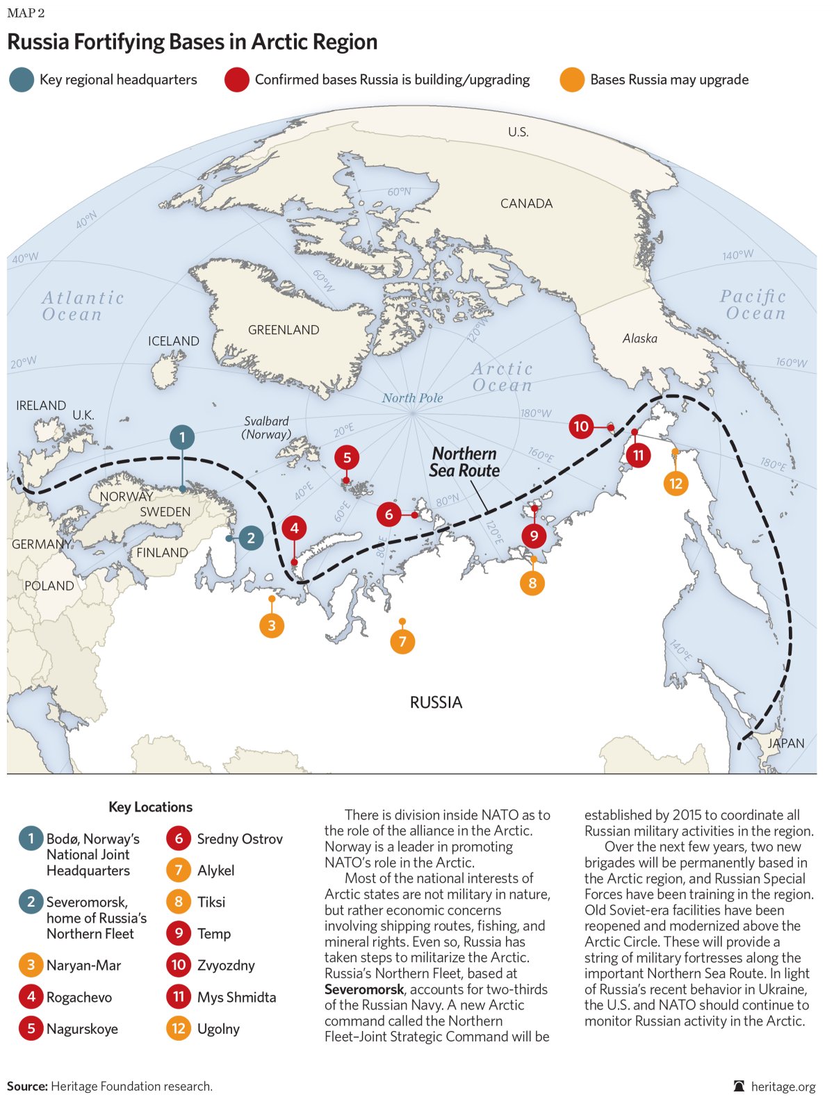
Today, the militarization of the area still goes on: “[my translation] Russia multiplies the signs and acts of militarization in the zone. Military exercises (parachuting, air patrols), reconstruction of installations in all of the islands (Wrangel, New Siberian, Novaya Zemlya, Franz Josef Land), orders of numerous ships among them new generation submarines (attack submarines and missile launchers), a complete program for the upgrading of the Boulava missiles … The [Northern Fleet] underwater base, near Murmansk (Severomorsk), seems to be in a state of complete reactivation.”(p.238)
Russia fortifying bases in Arctic region (Source: Heritage.org)
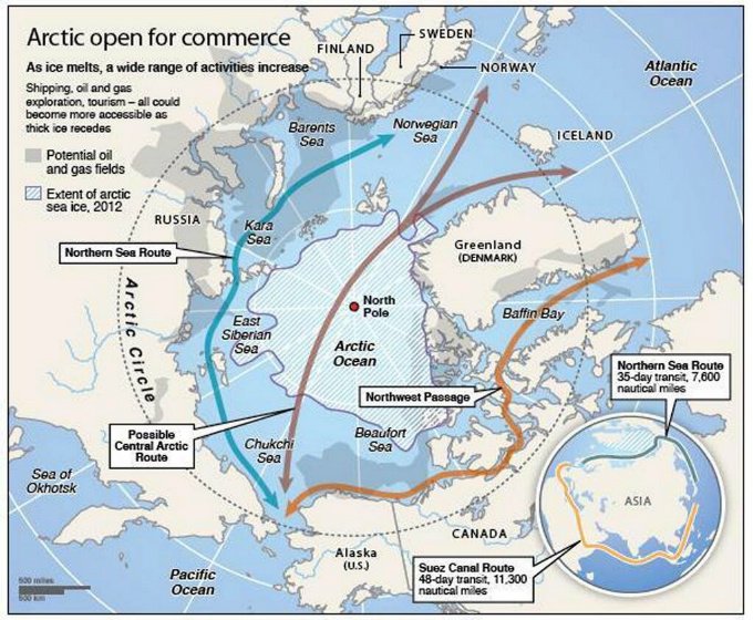
The transpolar maritime route
Geographic map showing the potential northern maritime routes (Source: www.businessinsider.com)
The Northeast Passage maritime route along the Siberian coast will be favored until the ice pack has melted at the pole (expected for 2025 instead of 2060 initially forecasted). So, in 2025, a new transpolar maritime route will be available to ship-owners. They will then be able to decide if they avoid the Siberian coast and the associated administrative hassle while they save an additional one thousand kilometers for a route from Rotterdam to Yokohama.
For more articles on geopolitics on my web site, click on the following link : Geopolitics