Street photography: parallel universe in Quebec City
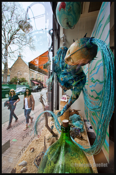
This photo was taken in May 2015 in Quebec City, in Old Quebec, with a Canon 5D MKII. The store decorator has chosen a striking subject with this weird humanoid floating in silence in the presence of a green glass bottle in the foreground.
But a shot taken from the street would have only offered a simple picture with a weird subject. In choosing the side window to take the photo, many other dimensions could be integrated in order to increase the final impact.
1. From the side window, the photographer can add people’s reaction to the humanoid. But there is a bit of waiting involved until the appropriate persons pass by.
2. You can see multiple reflections from the front and side windows that are now visible in the sky.
3. The old architecture on the other side of the street offers a surprising contrast with the modernity of the main subject.
4. The eye naturally moving from left to right, the humanoid’s head has been positioned in the upper right corner of the picture. Once the viewer sees the head, he then follows the blue poneytail to witness the reaction of the two persons on the sidewalk. The loop then starts again.
5. The orange element facing the humanoid offers a strong orange-blue complementary color contrast that should not be neglected to increase the visual effect.
6. Finally, the converging lines help to add depth and increase the visual impact.
This is a photo that could have been much more standard if taken from the sidewalk. The fixed lens used was a Canon 14mm 2.8L.
For other street photography pictures posted on my site, click on the following link:
Street photography – Le savoir-faire du photographe de rue (french version of The Street Photographer’s Manual)
We buy this book with the initial intent to learn about the different aspects of street photography, the goal being to increase our practical knowledge. We close the book with the feeling that we learned way more than we anticipated.
David Gibson’s work offers more than advices. In order to make it more fulfilling for the reader, the writer takes care of adding twenty very interesting portraits of renowned photographer’s working method and interests. Those names include Blake Andrews, Johanna Neurath, Matt Stuart and Maria Plotnikova. The reader improves his knowledge of photography history at the same time as he acquires new tools that will help him in his street photography practice.
Photographing people on the street is not necessarily easy. It takes determination to carry out a project that will include a person, especially if you are not working with a telephoto and you want to capture a scene where all the faces are visible. The author explains what kind of preparation is needed and he insists on the importance of avoiding disrespect toward others.
But street photography is not only about people, although approximately 75% of those pictures include a person. Other subjects of interest are, for example, experimentation with objects, shadows, empty spaces, abstraction, photographing through glass or wet surfaces, etc.
The writer has divided his book into twenty projects, to which he added, for each project, a road map. The latter can be used as a concise guide every time the street photographer puts in practice his newly acquired knowledge. If he wishes, the reader can rapidly get to work, using the ideas proposed within the twenty different themes.
The book is easy to understand and goes straight to the point. If the reader wishes to dig deeper in a specific aspect of street photography, he is given multiple internet site references.
This high quality book will surprise you and certainly be an inspiration in the preparation of your next street photography session.
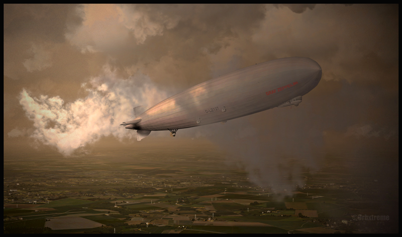
D-LZ127 Graf Zeppelin au-dessus de l’Allemagne (FSX)
Using ORBX Global program, I took this FSX screen capture of the Graf Zeppelin over Germany. The cloud effects are derived from REX and the Zeppelin itself was found on flightsim.com and it is a free software. For a better atmosphere, if you decide to take a screen capture, fly the Zeppelin either during the morning or at dusk while there is still enough light, and so that the sun will strike the balloon from the side.
Few videos are available on YouTube to show you how to deal with the Zeppelin. It’s not enough to apply full throttle and hope that it will rise because it will not. You first have to take care of the ballasts. But within only few minutes of watching the videos and applying the correct manoeuvers, I promise that you will be airborne and then the rest will come pretty naturally.
The picture was slightly edited with Photoshop to add some constrasts to the screen capture.
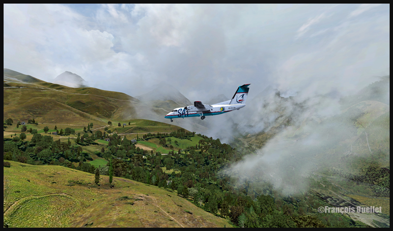
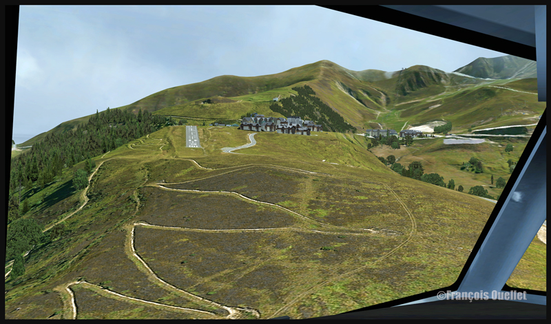
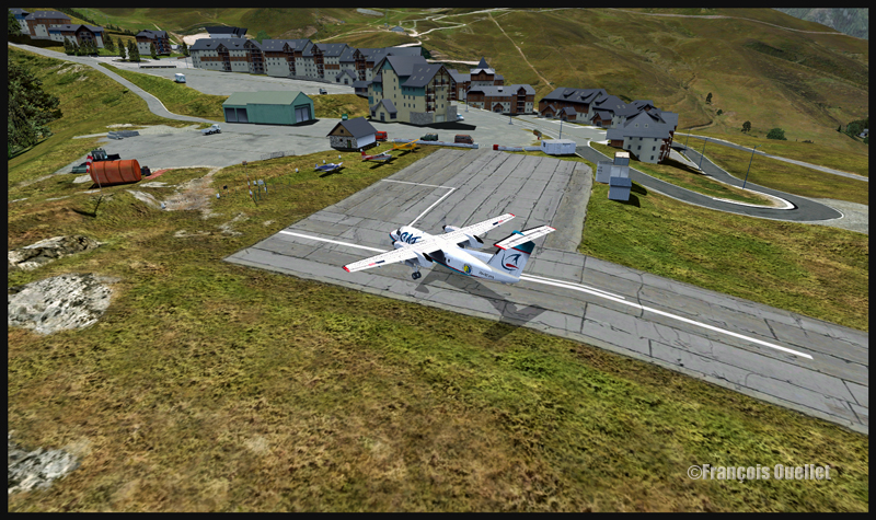
A Sat Airlines aircraft is on final for the Peyresourde mountain airfield
Flight simulation allows the use of all company liveries and types of aircraft. In the present case, a DHC-8-227Q from Sat Airlines, with the Sakhalin Energy logo, has mysteriously found itself inbound for the Peyresourde mountain airfield.
A Sat Airlines aircraft is on final for the Peyresourde mountain airfield
A Sat Airlines aircraft is on short final for Peyresourde mountain airfield
Peyresourde Balestas is located in the Pyrenees, at an altitude of 1580 meters. Its runway is only 335 meters long and has a 15 degree slope. The beginning of the James Bond movie “Tomorrow never dies” has been filmed there. The runway is long enough to accommodate the DHC-8-227Q as the plane’s excellent braking capacity is even improved by the sloped runway. If you touch early enough, you won’t even have to apply full braking power.
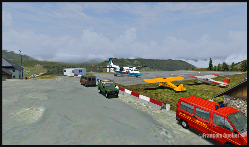
Sat Airlines Sakhalin Energy and the Peyresourde mountain airfield (fsx)
A Dash 7, with its superb ability to operate from any kind of field, would also fit in there, providing the amount of fuel and cargo is well calculated. Because what lands must also takeoff.
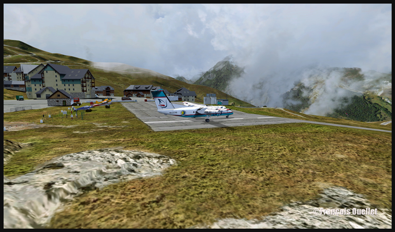
Peyresourde Balestas and the DHC-8-202Q Sat Airlines Sakhalin Energy (fsx)
The Peyresourde Balestas mountain airfield is made by LLH Créations, from France. The company has already produced four mountain airfields located in the French Alps. This is the first one in the Pyrenees.
Virtualcol FS Software created the Dash-8 used for this flight. For a very reasonable price, that company offers, in one bundle, an astonishing amount of liveries and all the types of DHC-8. Their product is detailed enough and really takes lower end computers into account when it comes to FPS (frames per second). Don’t expect the same realism as with the Q400 from Majestic Software though: Majestic’s Q400 is on a category by itself in the sim world and the price is adjusted accordingly.
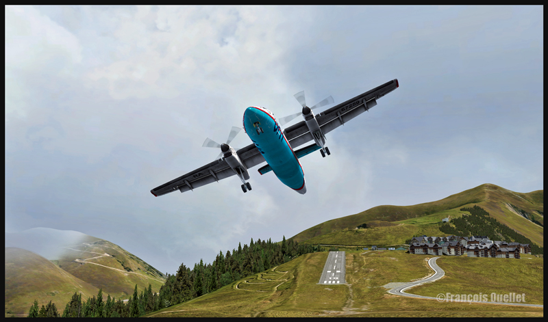
The fun will not be over after you land. You will find that the takeoff is quite spectacular. Apply the brakes, full power and the necessary amount of flaps and let it go! You’ll see that the runway’s end is coming quickly and that you’re building speed like you never believed possible with a Dash 8!
The Peyresourde Balestas airport and a DHC-8-202Q aircraft owned by Sat Airlines Sakhalin Energy
A DHC-8-202Q owned by Sat Airlines Sakhalin Energy is leaving the Peyresourde Balestas runway
Your passengers will certainly remember that mountain airfield. So will you!
If you want more ideas of flights that would test your nerves, just head to the “challenging virtual flight” section of this website.
For more articles on flight simulation on my web site, click on the following link : Flight simulation
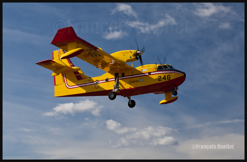
The CL-415 is on final for runway 11 at the Québec Jean-Lesage international airport. Each Spring, the Canadair Cl-215 and 415 pilots go through annual training before being deployed across Quebec territory in preparation for the next forest fires season. This picture was taken with a Canon 5D MKII. The speed was 1/320, aperture 8.0 and ISO 250 and a polarizing filter was installed on the lens. The photo was taken using a Canon 70-200 f2.8L IS II USM.
For other articles on aviation and photography, click on the following link: Aviation photography
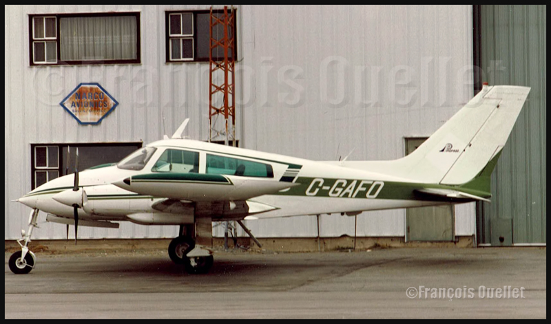
Cessna 310 C-GAFO parked on the ramp at Rouyn-Noranda (around 1986-88)
During the summer season, air surveillance is needed to watch for new forest fires in the center and north of the Quebec Province. There are periods, sometimes many days in a row, where the pilots do not observe anything significant. They accumulate hours of flying, quietly waiting to see a new fire or expecting to be directed by a dispatcher to a new problematic area. Those pilots also act as spotters for the Canadair CL215’s and CL415’s.
During the eighties, in the Abitibi region, a Cessna 310 had been in flight for few hours and the pilot had not spotted anything worth a call. Wishing to add a bit of action to his flight, he decided to descend and follow the meanders of a river at an extremely low altitude. As he exited a bend, the pilot faced a standing fisherman in its boat, angling in open water. Imitating the gestures of the fisherman, the pilot later told the Transport Canada flight service specialist (FSS) in Rouyn-Noranda (CYUY) that he was not the only one surprised…
It might be hard to believe that an aircraft could fly that low, especially when exiting a bend in a river. But after many decades in the aviation world, I can say that almost everything is possible. I imagine the fisherman’s reaction, quietly angling during a beautiful summer morning. While the fisherman lowers his head, the pilot pulls on the controls…
The expression in the pilot’s face showed clearly that he had had enough action for the day…I would like to swear that it was his last daring move, but it would be to ignore that this need for extreme flying is always present in some pilots.
For more real life stories on the Rouyn-Noranda flight service station and flight service specialists, click here:
1. A picture you would never have thought possible, because of extreme contrasts between brightness and darkness, is now accessible to you through HDR.
2. For a good HDR picture, you need at least 1) an interesting subject 2) an appropriate setting or background 3) the appropriate light and 4) a wide range in contrasts. That seems basic, but HDR will not save a picture that was not thought through.
3. You need a software like Photomatix, to transform several pictures taken at different exposures into one HDR picture. But this is only the first step. You will also need another editing software to improve the general result after Photomatix has been used.
4. A tripod is required to help Photomatix align the pictures and create the HDR effect.
5. As with your normal pictures, it is always better to try to use the lowest ISO as possible.
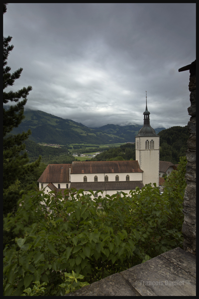
Gruyères, Switzerland, 2013.
6. It is safer to work with manual focus. This way, none of your shots will have been influenced by external objects without you noticing. It will always be the exact same focus throughout the HDR photo session. With automatic focus, you generally notice your blurred pictures when you’re back home and then it is too late (it will often happen under low light conditions).
7. The greater the contrast, the more exposures you need to take (up to nine) in order to match the dynamic range of your eyes.
8. The idea is to take each exposure at a different exposure setting. If you need seven exposures, an example of settings would be: -1, -2/3, -1/3, 0, +1/3, +2/3, +1. You might decide that three exposures only are necessary and go for -2, 0, +2 or -1, 0, +1. The choice is yours but you must take only the required number of exposures to avoid including too much noise in your shots.
Canon, 16-35mm, HDR format.
9. Throughout your HDR exposures of a specific scene, always keep the same aperture.
10. A scene is rarely perfectly balanced with light and shadows. If there are many shadow areas in the photo you want to take, then take more exposures over the recommended settings to ensure that you caught the whole dynamic range of the scene.
A house in Sainte-Pétronille, on Île d’Orléans, autumn 2012. HDR picture.
11. Inversely, if your scene has lots of highlight areas, take more exposures under the recommended settings.
12. Setting your camera to “automatic bracketing” is preferable because all the pictures are taken quickly thus avoiding to show any blurred picture in the final HDR picture. But if you want to show the movement of water in a creek, you don’t need bracketing: just take few shots with different time of exposure (in number of seconds). Just don’t overdo it otherwise it will give place to an uninteresting undefined white surface.
13. Check your LCD monitor so that none of the highlights are blown out. There would be a loss of details. For the same reason, you must avoid to block the shadows.
14. Always work with RAW files, it gives you better results. The RAW file already provides you with more f/stops then the JPEG file, and this before the transformation in HDR has even started).
15. Of all the lenses I’m using, the wide angle lens is my preferred one with it comes to HDR photography.
Spring light in the lower town of Quebec City
16. To improve the composition or enhance the general impact, crop the picture.
17. Not all pictures are appropriate for HDR transformation. If you want a dramatic silhouette as the final result, for example, HDR will not be appropriate. It will reveal too many details in the shadows and you will lose the high contrast effect that you were looking for. With practice, you will recognize where HDR is the most effective.
18. Whether you want a realistic picture or not, you can obtain surprising results with the combined effects of softwares like Photomatix, Topaz, Photoshop, Nik Software, Lightroom, Lucis Pro and so on. It’s only a matter of taking your time to experiment.
19. If you have only one picture on hand, like a shot you took years ago, and you would like to give it an HDR effect, you can use a software likeTopaz Adjust. There is an HDR effect section in that software that allows you to get a wide range of effects. But this is not going to be nearly as good as the real HDR resulting out of many pictures. The final editing step is, most of the time, done using Photoshop.
20. An unpretentious book about HDR is “Rick Sammon’s HDR Photography Secrets for Digital Photographers”. It is simple, colorful, well written and loaded with practical informations.
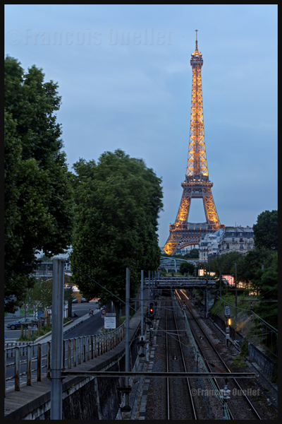
Eiffel Tower at night with HDR effect
Note: All the photos were taken with a Canon 5D MKII
Tales of a Dakota Pilot – The way it was 1929 – 1937
This is a simple and charming little book retelling the life stories of the pilot Fred Max Roberts Jr when he was flying his airplanes in the Bismark region, North Dakota, between 1929 and 1937. The book was written by his son, Fred Marke Roberts, so that some of his father’s stories do not fall in oblivion. You will find here a good idea of how things were done in the early years of aviation.
An original and easy way of refueling
When came the time to refuel, the pilots would regularly land on a farmer’s field. They knew that somebody had noticed the landing and, most of the time, a fuel truck would be sent without any previous arrangements. The pilot had nonetheless the duty to make sure he landed close to an easy access for the fuel truck. Sometimes, to simplify the refueling process a bit, the pilot landed directly on the road, outside of the city.
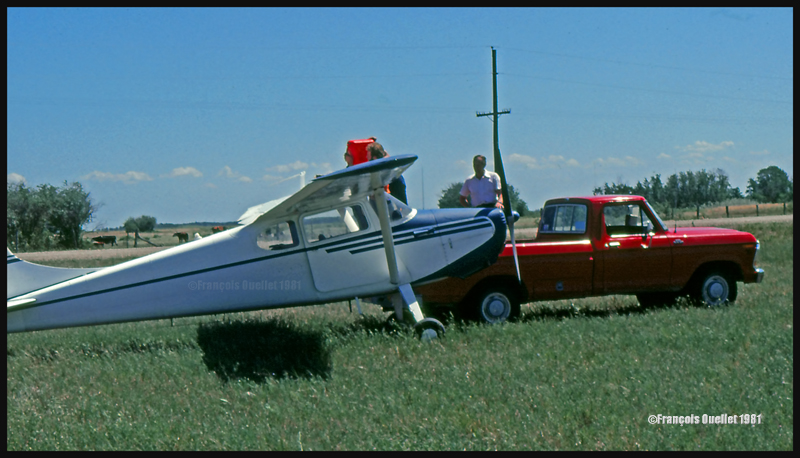
This habit did not seem to have change fifty years later when I did a 2650 kilometers cross-country flight with a Cessna 170B, between St-Jean-sur-Richelieu, Quebec, and Edmonton, Alberta. During the trip, I had to land in a field near Lundar, Manitoba, a Canadian province which is bounded to the south by North Dakota and Minnesota. Soon after the landing, a pick-up truck carrying fuel approached the plane. I had not made any arrangements for fuel. In my case, a precautionary landing was needed as the fuel gauges had started to give false indications. Since fuel was readily available, the tanks were topped before the next takeoff.
Landing in a field with a Cessna C170B in Lundar, Manitoba in 1981.
Killing coyotes against the county bounty
Coyotes where frequently attacking farmer’s livestock. When the situation was getting out of control, the farmers would phone Fred Max. The latter would take off with his Curtiss Junior Pusher, accompanied by an experienced shooter and they would spot and kill coyotes. Winter was the best season for hunting from the air since the coyote’s dark colored fur contrasted against the white snow.
The farmers, on their horses, were following the aircraft’s manoeuvers to spot where the coyotes had been shot. They then brought the dead animals back to their farm. Few minutes later, the aircraft would land as close to the farm as possible and the pilots picked up the coyotes, bringing them back to the county’s bureau in order to receive the published bounty for each killed coyote.
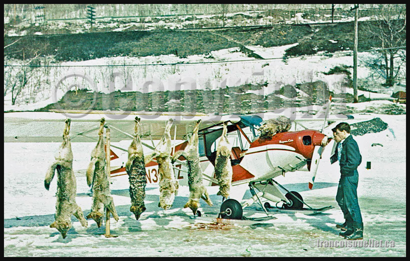
Super Cub and wolves shot from the air in Northern Ontario, Canada, on an aviation postcard dating from the sixties.
The American Midwest farmer’s hospitality
When a pilot landed in a farmer’s field, as a stopover on a long cross-country flight, he would often be offered a meal with the farmer’s family. If darkness was an obstacle for the continuation of the flight, the pilot was often offered a bed for the night. The next morning, after breakfast, and as a thank you gesture, the pilot would offer the farmer a courtesy flight.
A practical way to lower the costs associated with a long cross-country flight
An easy way to reduce the costs associated with a long cross-country flight was to offer airplane rides to villagers who had come to meet the pilot once at the destination. The pilot landed, waited a bit and knew that, soon, few people would come to him to ask for a ride.
The pilot Fred Max Roberts Jr hanging to the wing of his monoplane
A major concern for any pilot landing in a field was to find a fence to tie the plane as soon as possible to protect it from the strong winds blowing over the Midwest plains. But really strong gusts would sometimes break the ropes.
The pilot tells the reader that he was once immobilized in the middle of a field while a storm was quickly approaching. He got under the wing of his monoplane and hanged to it in order to add some weight. But that was not enough. A strong gust lifted the plane, broke the two tie-downs and sent pilot and plane flying at about ten feet in the air. Fearing that his plane would continue to climb without him at the controls, the pilot let go. The plane maintained a level flight while backing until it suddenly rolled and crashed.
Pilot and passengers are caught in flight by a tornado
Flying and meteorology manuals teach every pilot the necessity to avoid thunderstorms because, among other reasons, of the extreme ascending and descending air currents that are present in a well-developed cell. The pilot Fred Max Roberts Jr not only went through a thunderstorm but survived a tornado while he was in flight. His story was published in many newspapers at the time. Some of the articles are reproduced in the book.
As the pilot tells it, meteorological forecasts and weather observations were not as easily accessible as they are today. During a flight with passengers in his Waco 90 biplane, the sky suddenly darkened and the weather degraded rapidly. The pilot tried his best to fly between two important cloud formations. He could hardly see his instruments due to the lack of light, even if the flight was made during the day. He was fighting to avoid being disoriented.
Suddenly, the plane started to gain altitude rapidly by itself. The pilot nosed his ship downward and applied full power. This was useless. The aircraft was still rapidly climbing, tail first. Then the ascent abruptly stopped and a dive ensued. He pulled on the stick to bring his Waco to a level flight, but the rapid descent continued. Having no other choice, he applied full throttle and set his plane for a normal climb. Again, the descent continued until the Waco was at about 500 feet above ground level.
Eventually, they got out of the storm and landed at White Rock. Fred Max then realized that his passengers, sitting in the open cockpit Waco during the storm, had not fasten their seat belts and were hanging for dear life to a brace running across the front of the passenger cockpit.
Those are some of the tales a reader can find in “Tales of a Dakota Pilot”, an unpretentious book but nonetheless a publication that might very well surprise many young pilots, as the 1930’s way of flying so differed from what a young pilot lives when he integrates today’s world of aviation.
I’ve just added a new VFR flight in the “flight simulation” section, under “standard virtual flights”. An Alabeo WACO takes off from Cushman Meadows, heads south-east towards the Skokomish Reservation, then flies over the Bremerton airport to the north-east and ends up landing at the Bear Gulch aerodrome, just in time for a BBQ. This was done using FSX. The first part of the cross country is for a starting virtual pilot but the last part requires a bit more experience.
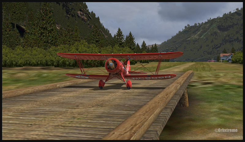
Waco on short final for Bear Gulch WA38 (fsx)
WACO landing in Bear Gulch WA38 (FSX)
It is a more demanding experience than what is normally found in the “standard flights” section, since it involves a final landing at Bear Gulch. The runway at that airport is only 1411 ft long, and quite narrow. So you have to plan your approach carefully. A little wooden bridge is part of the runway! Since the flight is done in nice VFR conditions and does not involve engine failures or using a really fast aircraft arriving on a short runway, I decided that the “standard virtual flights” section was more appropriate. Still, it is not an easy approach.
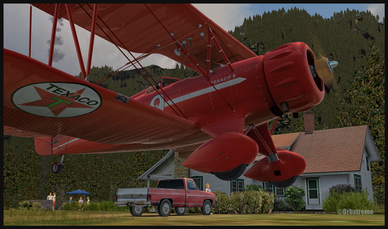
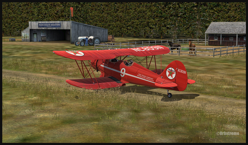
A Texaco WACO aircraft is taxiing on a wooden bridge at Bear Gulch, WA38
A Waco aircraft belonging to Texaco is taxiing in Bear Gulch, WA38
Cushman Meadows (KCMW) and the Bear Gulch (WA38) runways do not exist in real life but am I ever glad Bill Womack took the time to create them. His site can be found under Iblueyonder. The screen captures show both airports and the PNW region sold by ORBX. If you want nice shadows on the ground while not using P3D, just get CumulusX and set the season to summer, with scattered clouds in mid afternoon.
A Waco aircraft with a tractor in the foreground is parked at Bear Gulch, WA38
Some guests have already arrived in Bear Gulch. You will see the smoke rising from the BBQ being prepared while you are on short final. The guests will certainly be taking pictures of your approach, as you are flying a vintage aircraft. So, if there was ever a time to do things correctly, now it is!
For more articles on flight simulation on my web site, click on the following link : Flight simulation
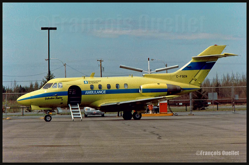
Medical evacuation aircraft HS-125 C-FSEN Valentine Lupien of the Quebec Government, around 1986.
During the eighties, while I was working as a flight service specialist (FSS) at the Transport Canada flight service station in Rouyn-Noranda (CYUY), I received a phone call from a Val-d’Or air traffic controller. He told me that there was a problem with the type K ARCAL. The ARCAL allows a pilot to remotely activate the runway lights.
Normally, the pilot can choose between three intensities: low, medium and high. But it now seemed that for an extended period, the ARCAL’s low intensity would not be serviceable. The controller told me to issue aNOTAM stating that nobody could use the ARCAL for an indefinite period.
I did not agree with that request. An ARCAL system that was left available would facilitate a pilot’s life by allowing him to choose between the remaining intensities during the approach, or on takeoff. The pilots of the Quebec Government HS125 in charge of medical evacuations during night time would certainly appreciate.
I told the controller that I did not know of any approved procedures relating to an ARCAL type K system failure and that I did not see why I would consider totally unserviceable a system in which only one intensity out of three was posing a problem.
He replied that those were the written procedures that could be found in the control tower and that I had to call his manager if I wanted to see them. How was it possible that official procedures pertinent to a system installed on many airports across Canada, with or without a control tower, could only be found in selected control towers? This was unthinkable.
Through my manager, I asked to receive a copy of those procedures. But it now seemed that those procedures were not in the Val-d’Or control tower but in the Montreal regional office. I tried to get them from that office, but nobody could find anything on the subject.
It was now obvious that those procedures never existed. The funny thing is that all the stakeholders were defending, one level at a time, the existence of those fictive procedures, for all kinds of reasons.
During those years, there was a program called “Incentive Award”, encouraging an employee to present new ideas that would improve the efficiency of the public service. If a proposition was accepted by the highest management levels, a certificate accompanied with a small amount of money would be sent to the employee by the Deputy Minister at Transport Canada. Realizing I would not obtain satisfaction from the regional management, I used the “Incentive Award” program to present my proposition.
One year later, I received a call from somebody who told me he was working at the national level, in Ottawa. He implied that my suggestion would not be accepted.
I told him that I paid, like other Canadians, to get the ARCAL system installed and that, as long as one intensity would remain serviceable, the ARCAL would have to be available to pilots. I made sure he understood that I could not care if he felt comfortable with the idea or not. He was advised that if he maintained his view on the subject, he would have to justify his action to the Canadian public and to the Minister of Transport, who, at the time, was Benoît Bouchard.
Two months later, I received a check and a letter from the Deputy Minister of Transport Canada thanking me for my suggestion that was improving the efficiency of public service. Fourteen months were needed to make the transition from fictive to official procedures that now apply to all Canadian airports equipped with this type of remote control of runway lights.
For more real life stories on the Rouyn-Noranda flight service station and flight service specialists, click here: