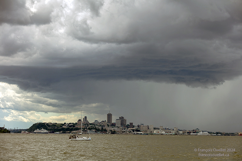
Thunderstorm at the start of the Transat Québec St-Malo 2024.
The tenth Transat Québec St-Malo on June 30, 2024 got underway with very unstable weather conditions, including a thunderstorm that forced a postponement of the start. While this weather temporarily disrupted the sailors’ plans, it delighted the photographers who came to capture the event. Above, a view of Quebec City taken from Île d’Orléans.
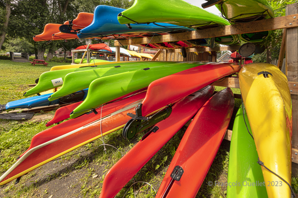
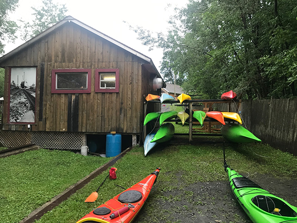
Sea kayaks at Saint-Laurent-de-l’Île d’Orléans 2023
On Sunday, September 24, 2023, the company Quatre Natures organized a certified level 1 sea kayaking course the St. Lawrence River, starting from Île d’Orléans. As registration was done well in advance, we had to be a bit lucky during the activity, as it would take place as much in good weather as in bad.
So, I take a chance. Fortunately, an incredible day awaits the six students: full sun and twenty degrees Celsius. How should we dress for the circumstances? We know that the human body temperature is 37 degrees Celsius. The kayaker adds up the water and air temperatures and compares the total to the temperature of the human body. With the river that day at 18 degrees and the air around 20 degrees, this gives a total of 38. As this figure is slightly higher than normal body temperature, we can wear normal clothing for water activities, rather than a wetsuit.
The morning is used to cover theory. No one sets foot in the water. The instructor discusses what the kayaker must have on board, the relative quality of different equipment, preparation, communications and radio frequencies, safety and hypothermia prevention, and so on.
Sea kayaking activity at l’île d’Orléans (photo Vadym Kravchenko)
After lunch, the kayaks are placed on the lawn and the vocabulary related to each part of the kayak is learned. The student then settles into the kayak and learns how to adjust the footbraces, hold the paddle, install the spray skirt, and so on. The boats are then brought to shore and kayaking begins.
First, we learn the basic maneuvers. How to embark and disembark, the trajectory the paddle should follow in the water depending on whether you want to go forward, backward or turn. We discuss the correct position of the body, arms and wrists on the paddle, and the importance of rotating the pelvis to force the paddle properly. We quickly realize the influence of side winds on the kayak, especially when it has no centerboard or rudder.
The river is considered level 2 for kayaking. The current is strong, and we have to deal with three-metre tides. The wind around the island is also stronger than in Quebec City. Level 1 kayakers are encouraged to seek out Level 1 locations to gain experience, and never to set off alone at this stage of their learning process.
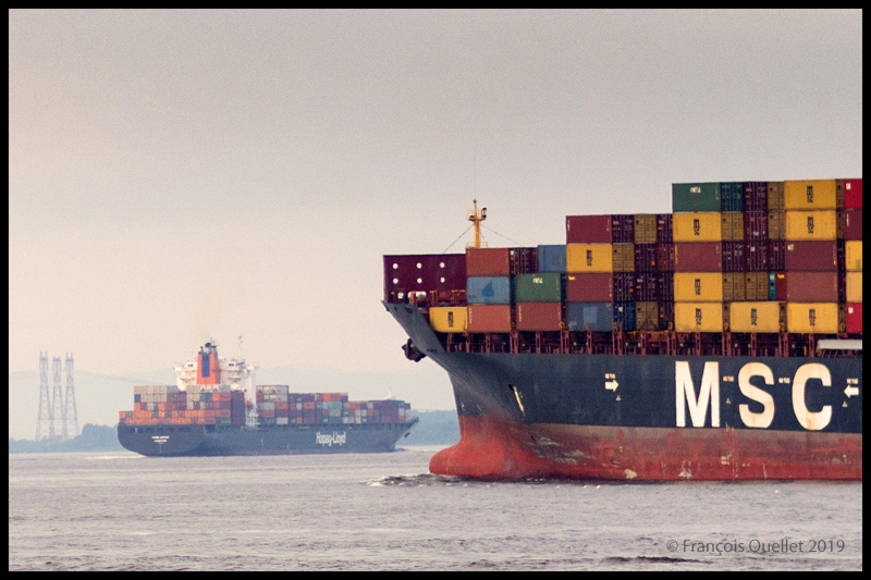
During the exercises, you can see the container ships and the various pleasure boats offshore. The larger vessels generate waves that take between five and ten minutes to reach the shore. When these approach, the instructor warns novice kayakers to turn to face the wave, so as to limit the effects on the boat.
The container ship Hapag_Lloyd Quebec Express and the container ship MSC Paola are sailing around Île d’Orléans near Quebec City.
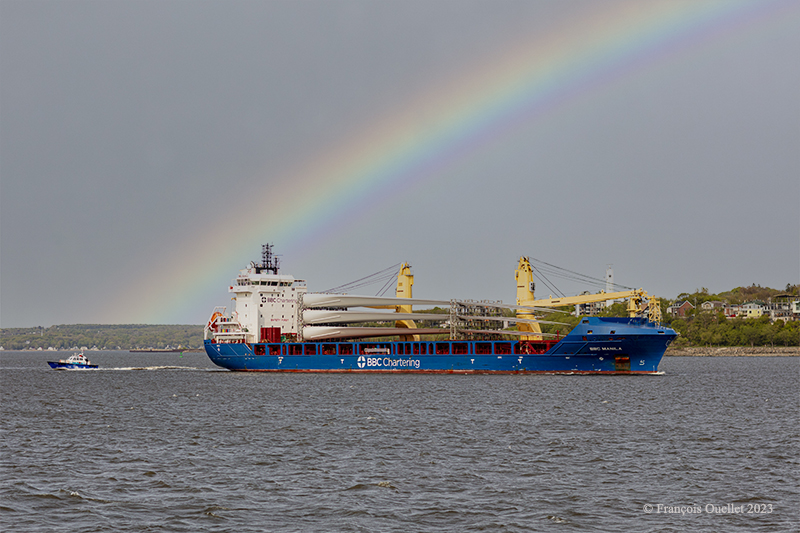
The BBC Manila carries wind turbine blades on the St.Lawrence Seaway near Quebec City.
Then come the emergency maneuvers: what’s the procedure for getting out of a kayak that’s just capsized? How do you help someone who has capsized?
I didn’t have time to get to this stage of the course. I capsized before. I don’t remember how I managed to extricate myself from the kayak and get back to the surface, but we’re not talking about an approved method here. The brain immediately detects the danger and organizes itself so that the body gets out of the kayak and the head doesn’t stay underwater for too long.
In the minutes that follow, the instructor teaches us how to perform the classic exit from a capsized kayak. We work in pairs. At Level 1, there’s no question of using the paddle to force the kayak to turn.
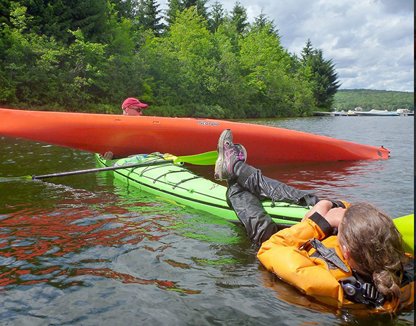
To obtain KDM 1 certification, everyone must lean sideways so that the kayak tips over. Once submerged, the student leans forward, unhooks the spray skirt attached to the kayak, and slowly taps the kayak’s hull three times to signal that he is in control of what he is doing. The instructor wants to avoid unpredictable reactions. We then push ourself out of the kayak by placing our hands at hip height on the coaming. As soon as we are out of the water, it’s imperative that we hold on to our kayak, thanks to the lifeline. It only takes a few seconds. Here and there, you can hear a little coughing as the student surfaces, but nothing more. A good sip of St. Lawrence River boosts the immune system.
Next comes the recovery of the person in the water. As we work as a team, the kayaker in difficulty clings to the front of our kayak and stays there until we catch up with his or her kayak, lift it onto our boat, empty it of water, turn it over and position it correctly.
Sea kayaking course level 1 with Quatre Natures (photo Quatre Natures)
The person clinging to the kayak then releases his or her grip, and depending on the method taught, climbs back into the boat while the latter is being held securely. The important thing here is to keep the center of gravity as low as possible. If the person doesn’t hurry and proceed step by step, the operation is a success every time.
A few more exercises follow, and it’s back to the beach on Île d’Orléans a few hours later. Once all participants have dried off and put on their warm clothes, the course concludes with a few weather notions, including the need to consult weather forecasts and radars, and to return quickly to shore when storm cells are present.
We also cover tide calculation (rule of 12) and how to attach a kayak to a car roof. How many attachment points? What equipment is available to make the job easier? Where should harnesses go to avoid breaking the kayak? Etc.
The KDM 1 certificate is awarded approximately eight to nine hours after the start of the course, depending on the instructor’s assessment. I noticed that on the way home, in the heat of the car, I really didn’t feel like rushing on the road. But you quickly come back to reality when you see how fast the cars are coming up behind you.
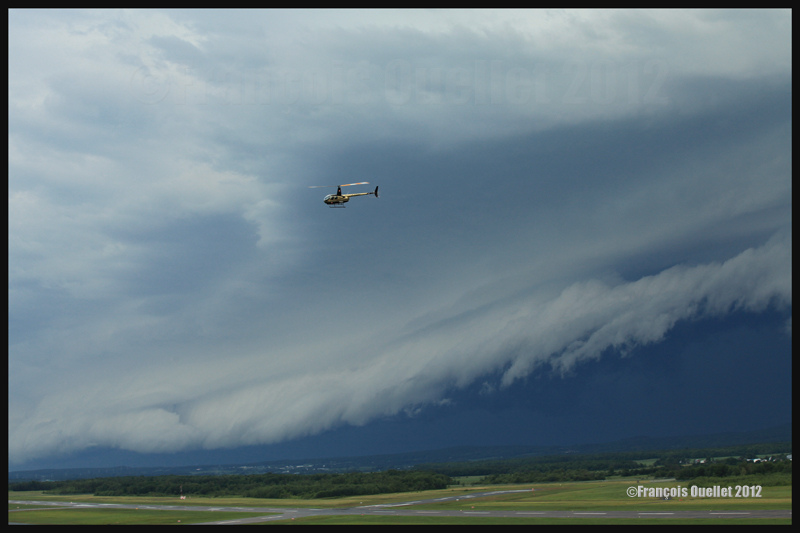
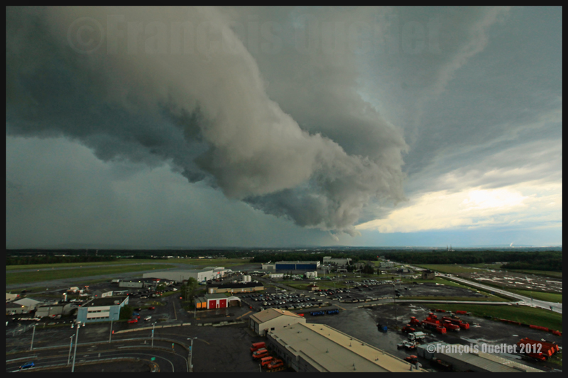
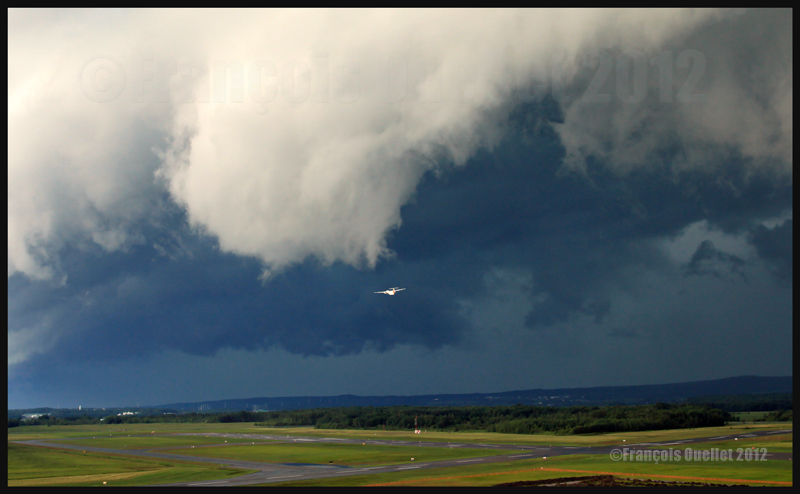
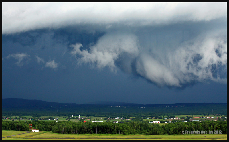
A roll arcus cloud in development ahead of a thunderstorm approaching the Quebec Jean-Lesage airport in 2012.
Summer 2012. A very active cold front had been sweeping across the province and was about to hit the Québec Jean-Lesage international airport (CYQB). Considering the winds and the temperature spread, as well as the weather radar, it was obvious that it would be a very interesting show.
The Nav Canada control tower and flight information center (FIC) being collocated, the common stairway surrounding the tower became a privileged spot from where to take pictures. As a flight service specialist (FSS) on a short morning break, I grabbed my camera and headed outside on the stairway, just in time to see a line of roll arcus clouds arrive over the mountains to the north-west.
A roll arcus cloud ahead of a thunderstorm heading for Quebec City in 2012
The first showers started, quickly followed by strong gusty winds and hail. In order to protect myself from the severe weather, I just had to slightly change position on the stairway and use the tower as a shield. Satisfied with my shots, I abandoned my observation post and let Mother Nature express herself.
A roll arcus cloud in development ahead of a thunderstorm approaching the Quebec Jean-Lesage airport in 2012.
An arcus cloud ahead of a thunderstorm approaching the Quebec Jean-Lesage airport in 2012
An arcus roll cloud in delopment near the Quebec Jean-Lesage airport in 2012
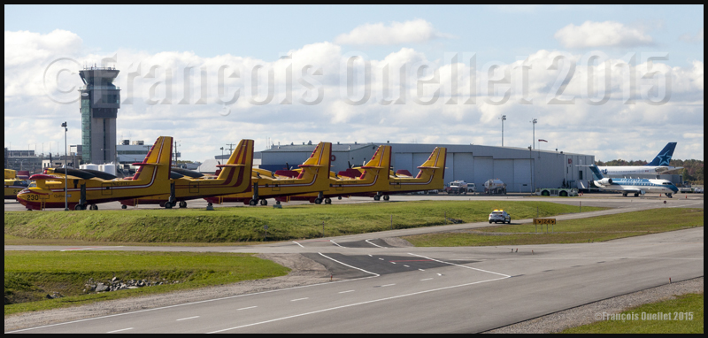
Nav Canada control tower with, in the foreground, several CL-215 and Cl-415, a Nav Canada Challenger, and an Air Transat Airbus at the Quebec Jean-Lesage international airport (CYQB).
On a stormy summer day, Air Canada called the Nav Canada flight information center (FIC) at the Quebec Jean-Lesage international airport (CYQB) on the Montreal frequency. The pilot was flying an Airbus and was about to take-off from the Montreal Pierre-Elliott-Trudeau international airport to Halifax, but there was violent weather that had to be avoided.
Normally, big airlines have their own briefing and flight planning services. However, rapidly changing weather sometimes requires last minute adjustments. In the case of the Air Canada flight, severe thunderstorms forbid a direct path from Montreal to Halifax. The pilot was looking for the best option: go around the thunderstorms by flying north over Mont-Joli then eastward to Halifax or fly southward to United States then head east to Halifax.
Both solutions were possible but the objective was to pick the route that would diminish the pilot’s chances to have to divert to an alternate airport.
Radar imagery became the essential tool to propose a solution. Knowing the time lapse between two images, it was possible to evaluate the weather system’s speed. By calculating what was the distance left for the system to arrive in Halifax, and knowing the system’s speed, the flight service specialist (FSS) was able to estimate as precisely as possible the time when the thunderstorms would move over the destination airport.
The pilot having calculated the estimated time of arrival to Halifax for both the south and north routes, and now knowing at what time the weather system would be over Halifax, he understood that the best option was the southern route through United States. If there was no last minute modification in the system’s speed, he would be able to land in Halifax between twenty and thirty minutes before the first thunderstorm cells arrive over the airport.
It is fairly uncommon to receive an official feedback from the pilot of a big company like Air Canada. But the next day, surprising the flight service specialist (FSS), the pilot called back, presenting himself as the one who had made a flight from Montreal to Halifax the precedent day. He wanted to thank the FSS who had helped him in his decision making since, as he said it, the route via the United States had been a success and he was able to land his Airbus thirty minutes before the arrival of the thunderstorms. That kind of call certainly helps any employee to start a working day on the good foot…!
The Nav Canada flight information center (FIC) in Quebec City (CYQB) does not normally take calls from the general public since air traffic services are centered on the needs of pilots.
But a particularly urgent situation sometimes dictate a more flexible approach. I remember a telephone call we received on the 800 line, during a very hot summer day of 2007. A worker in charge of the installation of dynamite in a mine in the Abitibi region told the flight service specialist (FSS) that he was working for a big company and that an important blasting operation was to be undertaken soon. He was in the middle of the blasting site, having just completed the installation of the detonators and explosives on the whole area.
He was wondering if there could be something he did not know about the weather since there were very dark clouds coming his way. The flight information center FSS was aware of the meteorological situation in Abitibi, and it was certainly not appropriate for a blasting operation. The caller was told that gigantic thunderstorm cells were forming in his sector and that the lightning detectors were already recording hundreds of strikes.
His actual position, in the middle of detonators and dynamite, was certainly problematic, to say the least. Without asking anything else, he told us that he was getting out of the site quickly…
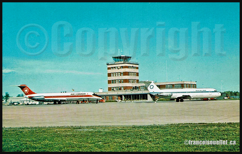
Old Quebec airport terminal with an Air Canada DC-9 and a QuebecAir BAC 1-11 (on aviation postcard)
Around 1996, during the summer, an Air Canada DC-9 captain visited the Transport Canada flight service station in Québec City (CYQB) to receive a last minute briefing on the weather conditions between Quebec and Toronto.
All the passengers were already on board, but the captain had noticed a rapid change in the size of thunderstorms approaching the Québec City airport. Wishing to make the best decision, he requested the latest information on the approaching line of thunderstorms before proceeding with the takeoff.
The weather radar and satellite pictures showed a wall of convective cells that a DC-9 would not be able to go through. It would not fly high enough nor be able to go around the system unless it made a detour through Val-d’Or to the north or the Tennessee to the south.
The captain already knew the consequences of his decision. He nonetheless took the phone and called Air Canada’s dispatch in Toronto, announcing that he would not leave Quebec until the weather was acceptable. He could envision the missed transfers in Toronto for most of his passengers, and their bad mood in face of the lengthy delays he expected in Québec City.
Nevertheless, his decision was made and he left the flight service station satisfied. He knew very well that a line of heavy thunderstorms had often been the cause of accidents and that no aircraft, whatever the size, was safe when dealing with a wall of severe thunderstorms.
The flight service specialists (FSS) were happy with the captain’s decision since, throughout the years, the FSS often witnessed far less commendable behaviour from pilots of all categories. Judgment is the capacity to evaluate consequences, and it is not given to everybody.
The weather engine ASN (Active Sky Next), like FSGRW, OpusFSI or REX updates the weather by downloading the latest information from the internet. There is also a possibility to use historical data (up to two years back).
ASN, FSGRW and OpusFSI use the default FSX cloud texture sets. So those weather engines can benefit from additional cloud texture sets (from REX for example) for a better visual depiction.
The cloud locations and coverage are accurate as well as realist. Thick overcast layers can be displayed. The cloud transitions are smooth, as well as the vertical variations in temperature, wind speed and wind direction.
Cloud-based effects include in-cloud reduced visibility, related turbulence (in cloud or when entering or exiting a cloud formation), accurate position of precipitation according to the type of clouds and to your position relative to the cloud formation.
Microbursts, wind shears, hail, turbulence as well as updrafts and downdrafts effects are modelled for thunderstorms. There are aural wind shear alerts when flying through a thunderstorm cell: That will nonetheless not be of great help if you attempt to cross a strong thunderstorm as, like in real life, you might not succeed…
You can use the radar to navigate through bad weather since radar and cloud positions are synchronized. The radar shows the intensity of precipitations as well as the echo tops.
Voiced warnings will be triggered when new Airmets and Sigmets are issued. They cover the world and can be viewed on a map. Associated icing and turbulence are added according to the warnings.
In flight, you can receive voiced weather updates through ATIS, FlightWatch or FSS.
ASN corrects the problems sometimes associated with low-level clouds, like inaccurate coverage and wrong position of the clouds, or layers that are really too thin.
Like with other weather engines, there is a flight planning mode. You can enter, import, or build a flight plan, as well as change the flight plan and waypoints at any time before or during a flight.
The weather, airports and navaids are displayed and can be edited, added or erased. The forecasts are available through graphics or text. If, along your route, there is no Metar issued for few hours, the engine will use the forecast to update the weather.
The thermals are modeled using the temperature and surface of terrain.
The wake turbulence trails are visible and, like in real life, are moving with the wind.
ASN does not rely only on interpolation to cover the oceanic areas and other territories where there are few weather stations.
The developers of ASN say that they have created a realistic hurricane simulation based on actual hurricane data. Their program would automatically disregard the ground data that seems incorrect. I cannot comment about the realism of that simulation since I have not tried it yet. But if it is correctly modelled, this function should interest whoever wants to experiment what it is to fly in or near a hurricane.
ASN is compatible with FSX, FSX: SE and the P3D versions up to P3DV4. It can support a multi-monitor setup.
I am not listing all the characteristics of this interesting software since there are always new options added. If you want more details, I provided the link below. Like with all the other weather engines, take the time to see what each has to offer since they have quite different features and spectrum of options.
REX offers two important elements through its different products: 1) A weather engine that downloads real weather in your computer while replicating the different weather phenomenon, through its REX Essential Plus program and 2) very realistic cloud textures (through its add-ons like Overdrive, Texture Direct, Soft Clouds).
A flight planning mode is also included, as well as numerous options to create specific weather themes that take care of the appearance of the clouds, the quality of the light in the sky, the definition of the sun effects, the different textures and colors of water.
You also have the possibility to choose different runway markings, the sounds associated with thunderstorms and the type of lightning that will illuminate your virtual sky.
REX is compatible with all platforms, including X-Plane.
Here are the REX products, which each play a very different role:
REX Essential Plus: a weather engine and a product that contains cloud textures and multiple options in order to simulate as much as possible the real outside weather for the area you have chosen. The weather engine will soon be renewed with a new addition: REX Weather Direct.
REX Overdrive: adds 12 GB of cloud textures.
REX4 Texture Direct: adds another 16 GB of cloud textures, and a possibility to create complete weather themes according to your preferences, while you still have access to other themes created by all the virtual pilots of the REX community.
REX Soft Clouds: adds volumetric clouds in the lower layer of the atmosphere for a more realistic effect.
REX4 Weather Architect: a program that allows you to create a precise weather system then position it anywhere on the planet. This is not a weather engine: It will not look for new data on internet and download it in your computer.
REX Weather Direct: a soon to be released improved weather engine that will be compatible with DX9, DX10 and DX11 as well as with FSX, FSX: SE (Steam Edition) and P3D.
On virtual flying forums, users seem to have a preference for the Active Sky Next (ASN) weather engine combined with REX cloud textures. This is a good combination, but it’s not the only one that deserves attention: FSGRW together with REX cloud textures do an excellent job (this is the duo that I am using for very precise results). There is also OpusFSI with REX, ASN with ASN2012 (ASN weather engine combined with ASN2012 cloud textures) or even a REX only set of programs (soon to be available REX Weather Direct and REX cloud textures).
This all depends on your priority: the FSGRW simplicity and absolute realism, the facility to use a cockpit camera and the dynamic head movements supported mode of OpusFSI, etc. It is best to read a lot and take the necessary time before jumping to quickly to a conclusion.
Some weather engines might need tweaking or modifications to be compatible with the most recent versions of P3D, if we believe what is written on specialized forums.
1986. It was a beautiful summer afternoon at the Rouyn-Noranda airport (CYUY). The Transport Canada flight service station employees knew that a cold front was approaching and would soon sweep the airport. Until then, it was still a perfect day. Blue sky, light winds. At the time, the flight service specialists (FSS) did not have access to radar images or satellite pictures.
To get an idea of what was coming from the west, we were normally using an Environment Canada aviation weather forecast and the actual weather observations of two flight service stations in Ontario, Earlton FSS and Timmins FSS. Their last weather observation mentioned a wind shift and an isolated thunderstorm. But Timmins was far away and could only provide us with a rough estimate of the situation.
As I was working the evening shift on that day, I checked the wind speed indicator, as a reflex developed throughout the years. What I saw was kind of unreal. The speed indicator’s needle suddenly went from showing few knots to 20 knots, and then 40 knots, hesitated a little then went up to 60 knots and, in a final correction, reached 72 knots, which was about 134 km/h.
Everything was so peaceful around the flight service station. I looked through the window to detect any moving object. At that very moment, the wooden shed normally used by the fuel man passed in front of the station. That wooden structure must certainly have weighted few hundred kilos. The fact that it was moving at a good speed was a clear indication that the instruments were working properly. A squall line was associated with the cold front progression.
Everything that was not properly fixed to the ground started moving. In the next hour, strong thunderstorms going eastward moved in over Rouyn-Noranda. The Val-d’Or airport (CYVO) being located sixty miles east, it was clear that it would be hit directly in about two hours. I called the Val-d’Or control tower so that everyone got prepared for the squall line. That gave them enough time to tie everything correctly and damages were limited.
One hour later, everything was back to normal in Rouyn-Noranda and we profited from an ideal summer night.
For more real life stories on the Rouyn-Noranda flight service station and flight service specialists, click here:
Tales of a Dakota Pilot – The way it was 1929 – 1937
This is a simple and charming little book retelling the life stories of the pilot Fred Max Roberts Jr when he was flying his airplanes in the Bismark region, North Dakota, between 1929 and 1937. The book was written by his son, Fred Marke Roberts, so that some of his father’s stories do not fall in oblivion. You will find here a good idea of how things were done in the early years of aviation.
An original and easy way of refueling
When came the time to refuel, the pilots would regularly land on a farmer’s field. They knew that somebody had noticed the landing and, most of the time, a fuel truck would be sent without any previous arrangements. The pilot had nonetheless the duty to make sure he landed close to an easy access for the fuel truck. Sometimes, to simplify the refueling process a bit, the pilot landed directly on the road, outside of the city.
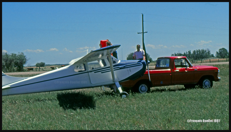
This habit did not seem to have change fifty years later when I did a 2650 kilometers cross-country flight with a Cessna 170B, between St-Jean-sur-Richelieu, Quebec, and Edmonton, Alberta. During the trip, I had to land in a field near Lundar, Manitoba, a Canadian province which is bounded to the south by North Dakota and Minnesota. Soon after the landing, a pick-up truck carrying fuel approached the plane. I had not made any arrangements for fuel. In my case, a precautionary landing was needed as the fuel gauges had started to give false indications. Since fuel was readily available, the tanks were topped before the next takeoff.
Landing in a field with a Cessna C170B in Lundar, Manitoba in 1981.
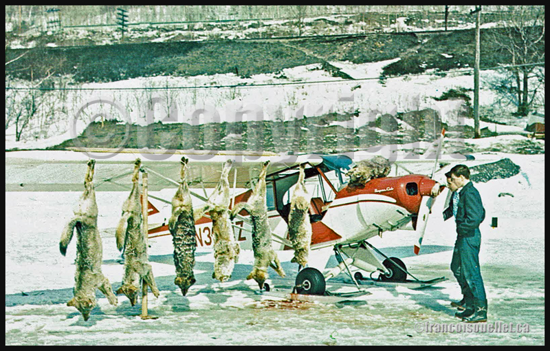
Killing coyotes against the county bounty
Coyotes where frequently attacking farmer’s livestock. When the situation was getting out of control, the farmers would phone Fred Max. The latter would take off with his Curtiss Junior Pusher, accompanied by an experienced shooter and they would spot and kill coyotes. Winter was the best season for hunting from the air since the coyote’s dark colored fur contrasted against the white snow.
The farmers, on their horses, were following the aircraft’s manoeuvers to spot where the coyotes had been shot. They then brought the dead animals back to their farm. Few minutes later, the aircraft would land as close to the farm as possible and the pilots picked up the coyotes, bringing them back to the county’s bureau in order to receive the published bounty for each killed coyote.
Super Cub and wolves shot from the air in Northern Ontario, Canada, on an aviation postcard dating from the sixties.
The American Midwest farmer’s hospitality
When a pilot landed in a farmer’s field, as a stopover on a long cross-country flight, he would often be offered a meal with the farmer’s family. If darkness was an obstacle for the continuation of the flight, the pilot was often offered a bed for the night. The next morning, after breakfast, and as a thank you gesture, the pilot would offer the farmer a courtesy flight.
A practical way to lower the costs associated with a long cross-country flight
An easy way to reduce the costs associated with a long cross-country flight was to offer airplane rides to villagers who had come to meet the pilot once at the destination. The pilot landed, waited a bit and knew that, soon, few people would come to him to ask for a ride.
The pilot Fred Max Roberts Jr hanging to the wing of his monoplane
A major concern for any pilot landing in a field was to find a fence to tie the plane as soon as possible to protect it from the strong winds blowing over the Midwest plains. But really strong gusts would sometimes break the ropes.
The pilot tells the reader that he was once immobilized in the middle of a field while a storm was quickly approaching. He got under the wing of his monoplane and hanged to it in order to add some weight. But that was not enough. A strong gust lifted the plane, broke the two tie-downs and sent pilot and plane flying at about ten feet in the air. Fearing that his plane would continue to climb without him at the controls, the pilot let go. The plane maintained a level flight while backing until it suddenly rolled and crashed.
Pilot and passengers are caught in flight by a tornado
Flying and meteorology manuals teach every pilot the necessity to avoid thunderstorms because, among other reasons, of the extreme ascending and descending air currents that are present in a well-developed cell. The pilot Fred Max Roberts Jr not only went through a thunderstorm but survived a tornado while he was in flight. His story was published in many newspapers at the time. Some of the articles are reproduced in the book.
As the pilot tells it, meteorological forecasts and weather observations were not as easily accessible as they are today. During a flight with passengers in his Waco 90 biplane, the sky suddenly darkened and the weather degraded rapidly. The pilot tried his best to fly between two important cloud formations. He could hardly see his instruments due to the lack of light, even if the flight was made during the day. He was fighting to avoid being disoriented.
Suddenly, the plane started to gain altitude rapidly by itself. The pilot nosed his ship downward and applied full power. This was useless. The aircraft was still rapidly climbing, tail first. Then the ascent abruptly stopped and a dive ensued. He pulled on the stick to bring his Waco to a level flight, but the rapid descent continued. Having no other choice, he applied full throttle and set his plane for a normal climb. Again, the descent continued until the Waco was at about 500 feet above ground level.
Eventually, they got out of the storm and landed at White Rock. Fred Max then realized that his passengers, sitting in the open cockpit Waco during the storm, had not fasten their seat belts and were hanging for dear life to a brace running across the front of the passenger cockpit.
Those are some of the tales a reader can find in “Tales of a Dakota Pilot”, an unpretentious book but nonetheless a publication that might very well surprise many young pilots, as the 1930’s way of flying so differed from what a young pilot lives when he integrates today’s world of aviation.