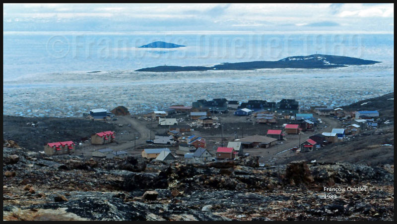
February 1990 in Iqaluit, on Baffin Island, Canada. Activities have slowed down a bit today. A temperature of -43C combined with 35 mph north-west winds means that the wind chill factor has gone down to -85C (NOAA Wind Chill Chart). We see far fewer pedestrians and even less motor vehicles on the city’s few roads. Many engines refuse to start and the motor oil has almost the consistency of maple taffy.
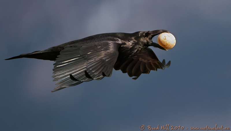
A special day indeed as, from the Transport Canada flight service station (FSS) tower, we can watch a very interesting performance. Huge ravens have picked that very windy day to have fun, regardless of the temperature. Flying under the wind near the FSS cab, they benefit from the venturi effect. There is no need flapping their wings. They just glide while occasionally correcting the angle of attack to adjust for the gusting wind.
The wind chill factor affecting living organisms, I find it quite spectacular to see those huge black birds having fun while we would expect that, with a -85C factor, ravens which must not absolutely fly would stay under cover until the weather improves a bit.
We can clearly hear the noise made by the wind on the wings of a huge raven when it glides over us. One day, I was walking near the Apex village under total silence. Suddenly I heard a raven glide low over my head. He was possibly checking if there was anything eatable out of that deformed shape transformed by multiple layers of winter clothing. There was only the rustling of the wind on its large open wings and no other sound. That was a very special experience.
The Transport Canada flight service specialists (FSS) in Iqaluit were sometimes amazed by the type of clothing chosen by pilots who were ferrying aircrafts from Europe to America.
Small and mid-size aircrafts required a flight plan including a stopover in Iqaluit, on Baffin Island, since refueling was necessary. One would think that pilots would have prepared themselves for unexpected situations and plan according to the extreme weather conditions prevailing at some of the airports along their route to America.
The FSS staff witnessed, on numerous occasions, small jets experience serious problems while refueling under very cold temperature. While the tanks were being filled up, the tires were deflating progressively.
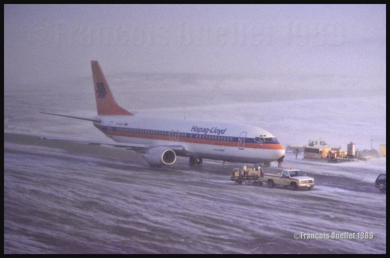
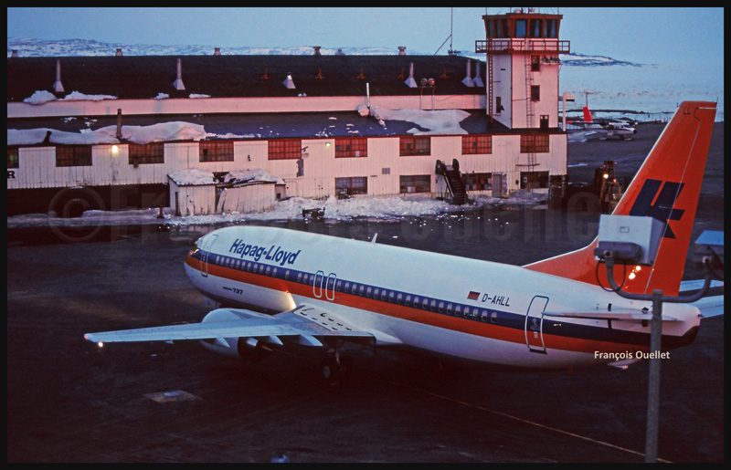
Hapag Lloyd D-AHLO B737-4K5 in its delivery flight in 1989, from Boeing Field (KBFI) to Iqaluit, and then towards Germany. It is being refueled during difficult weather conditions. This type of aircraft did not experience much problem with the cold weather, but it was not the case with smaller business jets
A small delay in the operations and the engines did not start anymore. The pilots got out of their aircraft, wearing only a thin leather jacket and summer shoes. Trying to protect themselves from the bitter cold, they gesticulated while talking with the fuel man who, himself, was wearing a thick Arctic suit that protected him from head to toes.
A thin leather jacket and summer shoes were certainly appropriate for Southern Europe but far from being useful on the apron of an airport where the wind chill factor often varied between -50C and -65C. The aircraft sometimes had to be towed in a hangar in order to be warmed up for hours, if not the night, and the transit fees grew exponentially.
I suppose that a pilot who lived such an experience remembers it today as clearly as the FSS staff, but not for the same reasons. And it is almost certain that he prepared accordingly for the next ferry flight.
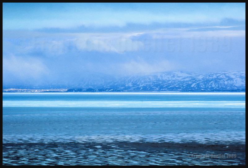
Mountains around Iqaluit, during a nice day when there is still ice in the bay. The blue tones are absolutely magnificent.
FSGRW is a weather generator and it uses downloaded data from the internet to simulate actual real weather all around the world (24,000 + airports).
The program simulates very well what is going on in the atmosphere up to FL520, including the depiction of hurricanes and tropical cyclones.
FSGRW does not come with its own cloud texture packages. Like for ASN(Active Sky Next) or OpusFSI, you must add a texture package from a third party (like REX for example). FSGRW will then use those beautiful textures to represent the downloaded weather from the internet, instead of the old cloud files that were created years ago by Microsoft.
FSGRW was not created to give you access to all kind of fancy options like automatic connections to the weather radar of big airliners. It is a simple but very efficient program that aims at representing the weather accurately.
FSGRW includes some well-known local weather effects.
Icefield in sight! A screen capture realized with the following products: FSX, FSGRW, REX, and a combination of Orbx creations. Final editing with a photo editing software (slight corrections only)
FSGRW is compatible with FS2004, FSX, ESP, P3D, Steam and X-Plane.
FSGRW gives you the possibility to use the actual weather present at one airport and transfer it to another airport. You have access to historic weather through a file-mode option. You may also choose to fly with dynamic or static weather. The weather updates are made every six minutes now that version 027 has been issued.
You can create your own flight plan and weather sequence.
FSGRW can be used through a network.
I own FSGRW and use it in combination with REX texture packages. I am very satisfied of the result. But I don’t doubt that ASN, OpusFSI or REX weather engines can provide excellent results as well. The only thing to remember is that you have to buy a weather engine AND cloud texture packages in order to improve the virtual weather’s visual aspect.
The weather engine ASN (Active Sky Next), like FSGRW, OpusFSI or REX updates the weather by downloading the latest information from the internet. There is also a possibility to use historical data (up to two years back).
ASN, FSGRW and OpusFSI use the default FSX cloud texture sets. So those weather engines can benefit from additional cloud texture sets (from REX for example) for a better visual depiction.
The cloud locations and coverage are accurate as well as realist. Thick overcast layers can be displayed. The cloud transitions are smooth, as well as the vertical variations in temperature, wind speed and wind direction.
Cloud-based effects include in-cloud reduced visibility, related turbulence (in cloud or when entering or exiting a cloud formation), accurate position of precipitation according to the type of clouds and to your position relative to the cloud formation.
Microbursts, wind shears, hail, turbulence as well as updrafts and downdrafts effects are modelled for thunderstorms. There are aural wind shear alerts when flying through a thunderstorm cell: That will nonetheless not be of great help if you attempt to cross a strong thunderstorm as, like in real life, you might not succeed…
You can use the radar to navigate through bad weather since radar and cloud positions are synchronized. The radar shows the intensity of precipitations as well as the echo tops.
Voiced warnings will be triggered when new Airmets and Sigmets are issued. They cover the world and can be viewed on a map. Associated icing and turbulence are added according to the warnings.
In flight, you can receive voiced weather updates through ATIS, FlightWatch or FSS.
ASN corrects the problems sometimes associated with low-level clouds, like inaccurate coverage and wrong position of the clouds, or layers that are really too thin.
Like with other weather engines, there is a flight planning mode. You can enter, import, or build a flight plan, as well as change the flight plan and waypoints at any time before or during a flight.
The weather, airports and navaids are displayed and can be edited, added or erased. The forecasts are available through graphics or text. If, along your route, there is no Metar issued for few hours, the engine will use the forecast to update the weather.
The thermals are modeled using the temperature and surface of terrain.
The wake turbulence trails are visible and, like in real life, are moving with the wind.
ASN does not rely only on interpolation to cover the oceanic areas and other territories where there are few weather stations.
The developers of ASN say that they have created a realistic hurricane simulation based on actual hurricane data. Their program would automatically disregard the ground data that seems incorrect. I cannot comment about the realism of that simulation since I have not tried it yet. But if it is correctly modelled, this function should interest whoever wants to experiment what it is to fly in or near a hurricane.
ASN is compatible with FSX, FSX: SE and the P3D versions up to P3DV4. It can support a multi-monitor setup.
I am not listing all the characteristics of this interesting software since there are always new options added. If you want more details, I provided the link below. Like with all the other weather engines, take the time to see what each has to offer since they have quite different features and spectrum of options.
(Precedent story: Iqaluit FSS and the Persian Gulf War)
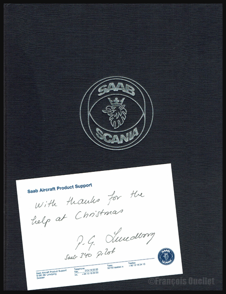
Book and message sent by a Saab-Scania pilot to the Iqaluit flight service specialists
I still have fond memories of a pilot who came up to visit the flight service specialists (FSS) at the Transport Canada flight service station in Iqaluit, in1990, during an icy Christmas evening. This Saab-Scania pilot had arrived from United States and he intended to cross the Atlantic toward Europe.
But the extreme cold prevailing in Iqaluit, on Baffin Island, had complicated the ground operations. The pilot’s tight schedule as well as the reduced services in effect for the Christmas holidays had given him all sorts of problems. Through his entire ordeal, he kept a professional attitude and we did everything possible to get him out of trouble.
Just before he left the flight service station, he asked us our name and mailing address in Iqaluit. Finally, once all his problems had been taken care of, he took-off from Canada towards his next stopover. Weeks went by and one day, my colleague and I each received a package from Sweden. It was a book about the Saab-Scania story and, inside, there was this little note: “With thanks for the help at Christmas”!
(Next story: A freelance demolition worker in Iqaluit)
In August 1990, Iraq invaded Kuwait. This invasion was unanimously condemned, even by countries that are traditionally aligned with Iraq. The United Nations reacted by giving Iraq up to January 15th 1991 to withdraw. But Saddam Hussein’s attitude clearly showed that there would be no withdrawal and that he intended to proceed with Kuwait annexation to the Iraqi territory.
Understanding that military force would obviously be necessary, United States (representing a coalition of 34 countries) started preparing for the conflict. Aircraft movements increased and short range military aircrafts that would have to cross the Atlantic used Iqaluit, on Baffin Island, as a stopover before continuing through Greenland, Iceland, Europe and finally the Middle East.
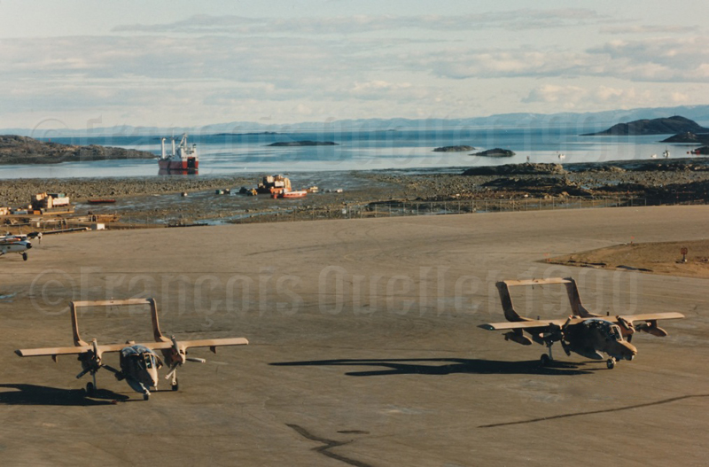
OV-10 Broncos transiting through Iqaluit in 1990 and heading for the Persian Gulf
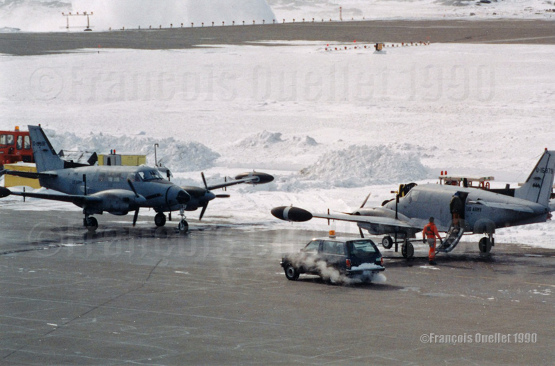
Starting summer 1990, the Iqaluit airport then became one of the mandatory stopovers towards Middle East for some military aircrafts. Soon we could see L-382s carrying large size items and some OV-10 Broncos painted with desert colors landing in Iqaluit. Later on during autumn, other specially equipped aircrafts like the U.S.Army RU-21 Guardrail Common Sensor also made stopovers in Iqaluit.
RU-21 Guardrail Common Sensor on a stopover in Iqaluit in 1990 and heading for the Persian Gulf
A Southern Air Transport L-382 also landed in Iqaluit. That company was sometimes used by the CIA for its operations.
Southern Air Transport L-382 N908SJ transiting through Iqaluit in 1990
As soon as a flight service specialist (FSS) was not busy with radio communications, he would head toward the briefing counter to receive the military pilots who had come to obtain the mandatory weather and flight planning information that would be used to safely cross the Atlantic.
HF frequencies used for international communications at the local Transport Canada flight service station were really busy. On top of the regular air traffic services normally associated with commercial aircrafts crossing the Atlantic, we were now dealing with the radio communications associated with numerous military cargo aircrafts like the C-5s Galaxy and others.
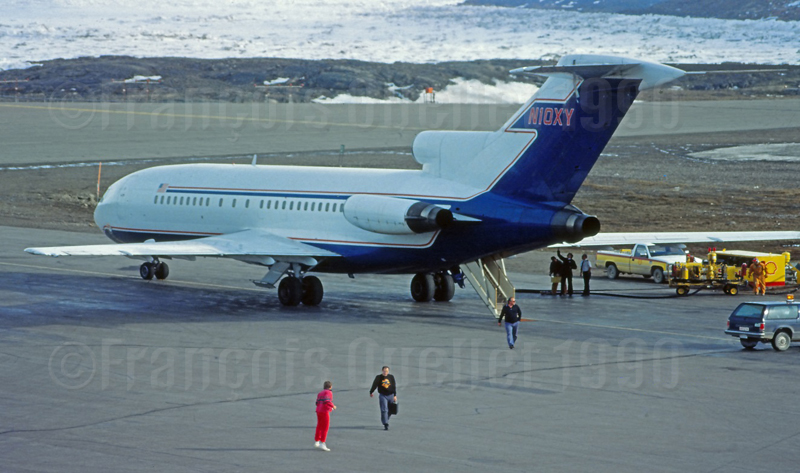
In the two weeks preceding the United Nations ultimatum, between January 1st and 15th 1991, the Iqaluit flight service station recorded a 266 % increase against the same period in 1990 in oceanic traffic transiting through its airport. Flights were mostly related with private or chartered business jets linked to international banks, petroleum companies and military organizations preparing for the events to come. We received, among others, aircraft types like the G1, G2, G3, G4, HS25, DA50, DA90, CL60, C550, LR25 and B-727.
Occidental Petroleum B-727 N10XY on a stopover in Iqaluit in 1990
One night of January 1991, while we were at work, one member of the staff took-off his headphones and calmly told me: “Son, the war has started”.
I will remember that special period since we did not receive a military training but, nonetheless, we witnessed and dealt with the preparation and aircraft movements associated with a major military conflict.
Moreover, for a short period, the Iqaluit airport reverted to the use it had initially been planned and built for in 1942, during the Second World War, which was a base created for short-range military aircrafts heading to Europe.
(Precedent story: the « Amalgam Chief » military exercise: B-52 bombers in northern Canada).
Aer Lingus Boeing B-737 on final for Iqaluit (1989)
This story is about a 1990 winter day where very bad weather conditions prevailed in Iqaluit, on Baffin Island, Canada. Bad as it was, the weather still allowed for takeoffs. Two airline companies, respectively owning a Boeing 727 and 737 had completed the boarding and expected to be airborne shortly. The weather deteriorating even more, the Transport Canada flight service specialists (FSS) had to tell the pilots that they could not proceed with the takeoff as the airport was now under the minimum visibility criteria.
The aircrafts were ready, the engines running and the pilots could not takeoff. There was a bit of tension in the air and the pilots finally decided that they would take a chance and takeoff under unacceptable conditions. The two captains were reminded by the FSS that if they tried to takeoff in the prevailing visibility, which was under legal minimums, an occurrence report would be filed against them.
The flight service specialist naturally received a reply in line with the pilot’s impatience. Nevertheless, the pilots took a second look at the weather and, thinking of a possible occurrence report, decided to delay both takeoffs.
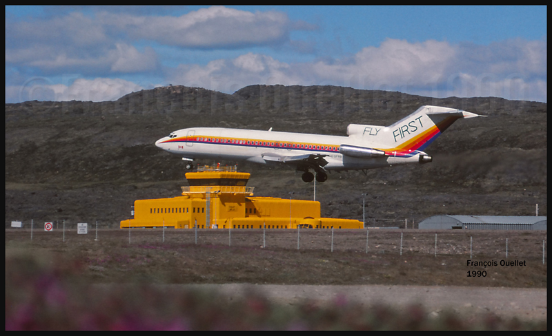
A view from the Iqaluit flight service tower: a First Air Boeing B-727 and a Canadian Airlines Boeing B-737A new Hapag-LLoyd (D-AHLL) Boeing B-737 has just arrived from Boeing Field in Seattle. Next destination: Germany.
In being so impatient to complete their flight, those captains were neglecting that there is always the possibility of an engine failure or other major emergency on takeoff. If they had lost an engine just after being airborne, it would have been impossible to return back to Iqaluit due to the extremely low visibility; they would have been forced to fly a very long distance with one less engine to get to their alternate airport, increasing the risks for the safety of the passengers.
The threat of a potential occurrence report, which has always been the prerogative of air traffic services, forced the pilots to wait for appropriate weather conditions.
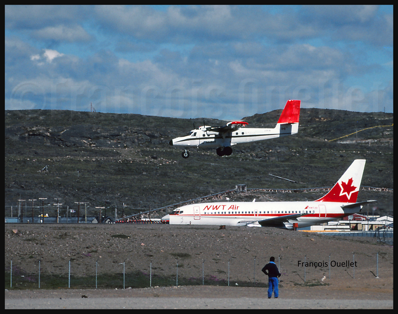
The Iqaluit flight service station tower and a First Air Boeing B-727 landing on runway 36 (1990)View from the Iqaluit flight service station tower of an Evergreen International Boeing B-727 (1989)A NWT Air B-737 on the taxiway and a Bradley Air Services Twin Otter about to land in Iqaluit (1989)An AirUK G-UKLB Boeing B737 is arriving in Iqaluit (around 1989)
(Next story: the lady who was robbed before my eyes)
(Precedent story: carrying a .357 Magnum to Iqaluit)
An American Trans Air Lockheed L-1011being refueled in Iqaluit, Canada, in 1989. I had the opportunity to leave the flight service station (the yellow tower) for few minutes to take this picture.
Before retelling some of the events that happened while I was working at the Transport Canada flight service station in Iqaluit, in the Nunavut (1989-1991), it is mandatory to present few important dates that will allow the reader to understand why the airport was initially an American military base.
1938. Hitler’s ambitions are such that Roosevelt deemed necessary to announce the following: “I give you assurance that the people of the United States will not stand idly by if domination of Canadian soil is threatened by any other empire ».
1939. Beginning of discussions between Canada and United States with regards to joint defense of the North American continent.
1940. Great-Britain was at risk of losing the war against a Germany that was progressing rapidly in its conquest of the European soil. When Denmark was defeated in autumn 1940, fear grew that the Germans would progress westward and establish operational military bases on the newly acquired territories.
Greenland belonging to a defeated Denmark, Germans would be using it to get closer to Canada. At the time, Greenland was the sole commercial source of cryolite, an essential component of aluminum used in aircraft production.
There was also a province which was not part of Canada in 1940 and which presented a strategic interest for an enemy in its war against Canada and United States: Newfoundland and Labrador.
In order for the war not to be fought directly on the North American territory, one had to keep the Germans busy in Europe. It therefore meant that Great-Britain must not be defeated.
1941. Ships carrying short range fighting aircrafts from America to Europe were regularly attacked and sunk by U-boats. It was imperative to change the route. Canadians and Americans were looking for the best sites that could accommodate the construction of runways allowing short range military aircrafts to fly up to Prestwick, Scotland.
This new route was called “Crimson Route” and the stopovers were Goose Bay in Labrador, Fort Chimo (Kuujjuaq) in Quebec, Frobisher Bay (Iqaluit), on Baffin Island in the Nunavut as well as three sites in Greenland (Narsarsuaq, Angmagssalik and Sondre Stromfjord (Kangerlussuaq). The Frobisher Bay coded name became “Crystal Two” base.
1941-42. Germans established the first inhabited weather bases on the Greenland coast in order to facilitate U-Boats operations across the North Atlantic. When those sites were discovered, they were destroyed by American commandos.
1942. U-Boats entered the St-Lawrence seaway and sank Canadian ships.
1942. The site initially chosen to establish the Frobisher Bay airport (the Crystal Two base) was Cromwell Island, located 20 miles south-west of today’s actual site for Iqaluit. This was until a new site was discovered (today’s site) that favored the construction of longer runways and allowed the beaching of flatboats loaded with cargo during the summer period.
A McAllister flat-bottomed barge will soon be unloaded in Iqaluit, during low tide.
A ships convoy carrying thousands of tons of cargo planned for the construction of the Frobisher Bay base arrived at destination. This convoy was nonetheless attacked by the U-517 U-Boat and the cargo-ship Chatham, carrying 6000 tons of material destined for Crystal One and Crystal Two bases was sank.
1943. An German automated weather station was built at Martin Bay, in Labrador, to facilitate the U-Boats operations. This weather station is now in permanent exhibition at the war museum in Ottawa. Pictures have been found were we can see smiling but armed German soldiers taking the pose near the automated weather station. Canada accidently learned about the existence of that weather station in 1980.
German automated weather station in exibit at the War Museum in Ottawa
Many German officers and soldiers who were captured in Europe were sent abroad while waiting for the end of the war. My grandparents, who owned a farm in St-Ignace, Quebec, became responsible, over time, for one German officer and two soldiers. They had only good comments on the behavior and desire of the prisoners to help on the farm.
1943. Both Frobisher Bay runways were now operational, although without being totally completed. The engineers did not have the knowledge of the Russians when it came to maintaining airport runways in the Arctic. Damages caused by permafrost were significant and the runways necessitated a lot of maintenance. The water present under the runways would sometimes surface suddenly and create five meter deep holes. Those runways needed a constant effort to remain usable.
The first runway to be built was eventually abandoned due to a wrong evaluation of the prevailing winds and the dangers associated with the surrounding elevated terrain. Today only remains the runway that we know in Iqaluit, although extended to 9000 feet. The year 1943 recorded 323 aircraft arrivals, of which only a small number made the complete trip to Europe.
1944. War took a new turn. The newly developed long range radars, allied to advanced technology in the detection and attack of submarines, radically diminished the U-Boats threat in North Atlantic. The “Crimson Route” airports were suddenly losing their pertinence. The Canadian government, worried about the massive presence of Americans in the Canadian Arctic, bought the airports from the American government.
1950. Canadians officially took control of the Frobisher Bay airport, but authorized an American presence since this airport had a new strategic importance in the cold war that followed Second World War. The weather station and runway maintenance were taken care of by American forces.
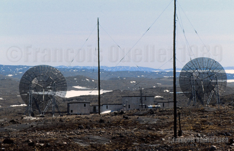
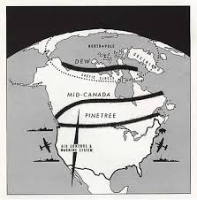
1951-53. A radar station was built on a hill northeast of runway 17-35. This station completed what was then known as the Pinetree line. This line was made of several long range surveillance radar stations; it covered all of southern Canada and gradually curved towards the north to end up in Frobisher Bay. All those stations were inhabited and could order interceptions at all times against potential enemy forces, by means of jet aircrafts.
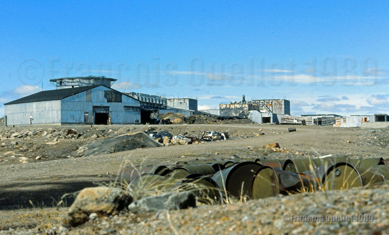
What is left of the old American military base in Frobisher Bay (Iqaluit), Canada. I took the picture in 1989.
1955. Americans received the authorization from Canada to build a SAC [Strategic Air Command] military base where numerous KC-97 tankers were stationed in support of B-47 bombers operations carrying nuclear armament. The base was built in 1958 and, until the end of its operations in 1963, parking space was occupied by at least seven KC-97. The SAC base was not needed anymore after the new Boeing B-52 bombers and KC-135 tankers were developed.
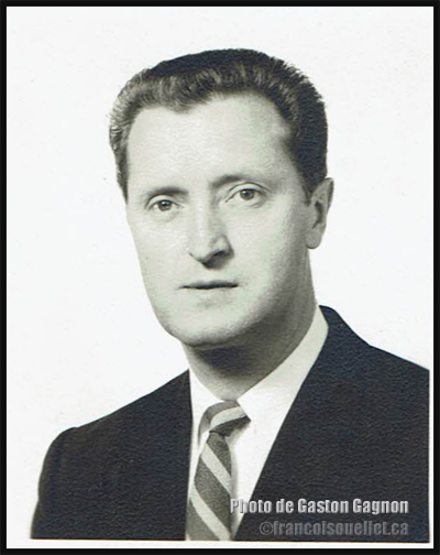
A French-Canadian military from Quebec at work in Frobisher Bay
Gaston Gagnon during the period where he served as a Canadian military in the communication field, at the Frobisher Bay station of the Pinetree Line in Canada in 1955. He died in 2016.
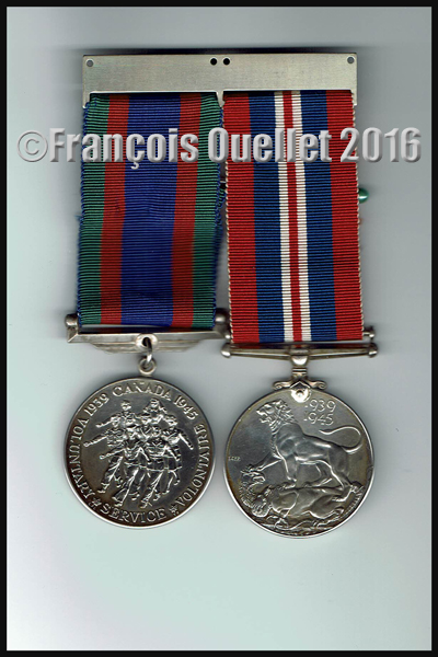
My uncle Gaston Gagnon was part of the French-Canadian military staff who was in service in Frobisher Bay. He volunteered for service during the Second World War (1939-1945).
War medals (volontary service and honorable service during the Second World War (1939-1945) belonging to the French Canadian Gaston Gagnon who died in 2016
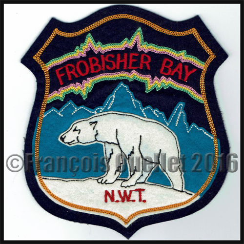
Frobisher Bay, N.W.T., Canada crest
He worked in the communication field during the Cold War and, after he died in 2016, I received some pictures that were taken in 1955 in Frobisher Bay. Those photos also witness of the American presence in Frobisher Bay.
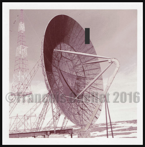
Radar dish at the Frobisher Bay, NWT, Canada Pinetree Line Station in 1955
American soldier posted at the Frobisher Bay NWT Canada Pinetree Line site in 1955
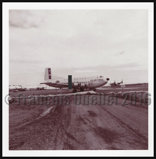
Globe Master C-124 aircraft of the Military Transport Air Service (U.S. Air Force) in Frobisher Bay, NWT, Canada in 1955 serving the Pinetree Line stations during the Cold War.
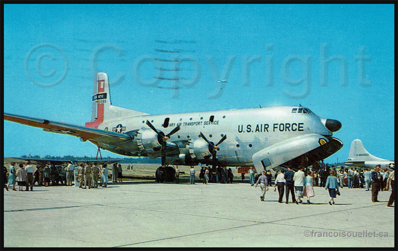
C-124 Globemaster. Military Air Transport Service in United States (around 1957)
Frobisher Bay, N.W.T., Canada crest
1960. The runway was extended from 6000 to 9000 feet.
1961. The Frobisher Bay radar station, part of the Pinetree line, was closed but the Polevault station remained in activity.
DEW and Pinetree lines over Northern Canada
1963. Americans left Frobisher Bay and gave control of the Polevault station to the DOT [Department of Transport], an older designation of Transport Canada.
Old American military base in Frobisher Bay (Iqaluit)
1964. The radio operator, and later flight service specialist (FSS) Georges McDougall, arrived in Frobisher Bay. All the village inhabitants eventually got to know Georges since he provided air traffic services there for at least thirty-seven years, seven days a week, on shifts work. He progressively became a privileged witness of all the unusual events to happen in the village and at the airport.
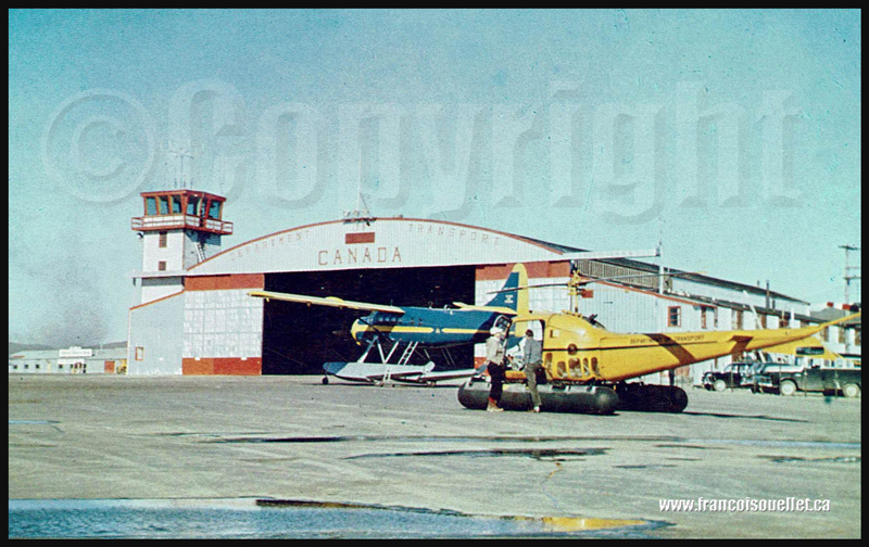
Below is a picture of the old DOT hangar and tower.
People and DOT Canada in Frobisher Bay NWT aviation postcard
1987. Frobisher Bay was renamed Iqaluit.
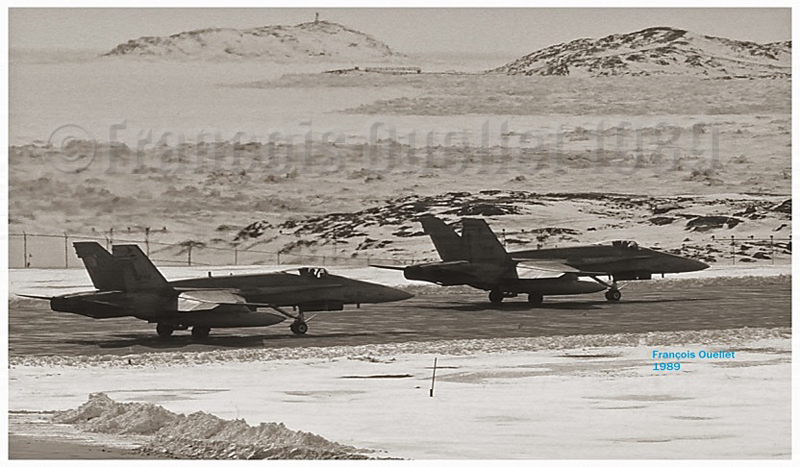
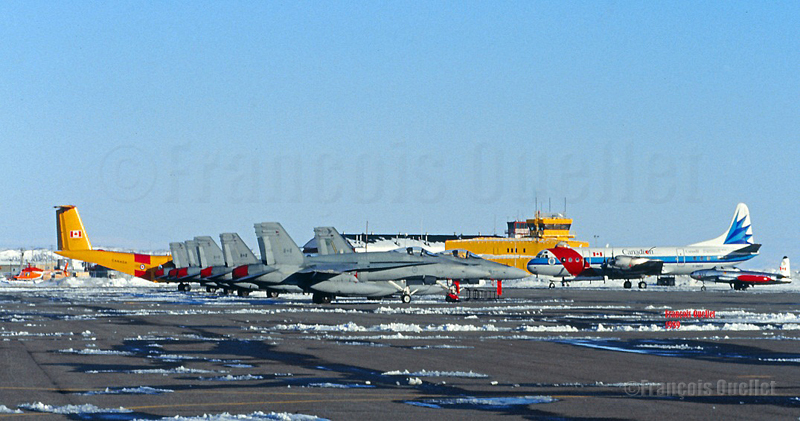
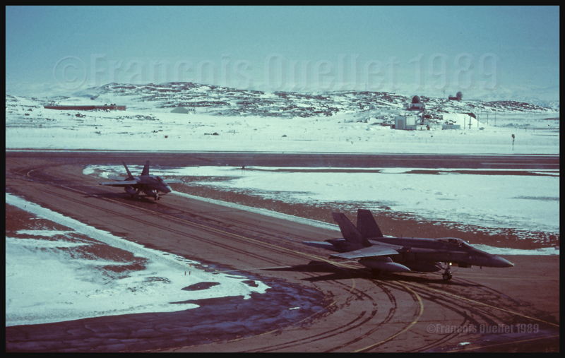
Two Canadian CF-18s holding short of runway in Iqaluit (1989)
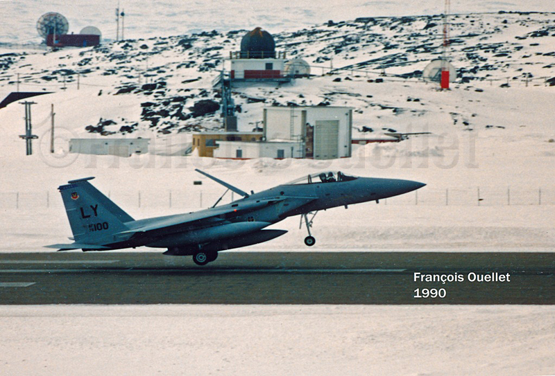
1989. Stacey Campbell wrote an article in News North that she titled: “Military Jets Fill the Arctic Skies”. She explained that NORAD (North American Air Defence) regularly held exercises aimed at testing the capacity of Canada’s new radar defense system to detect potential enemies approaching from the north.
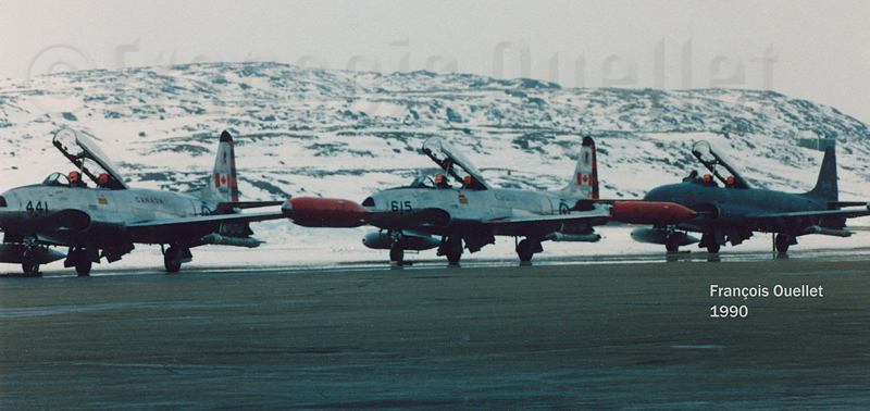
The interviewed military officer told Stacey that CF-18 fighter jets, tankers and B-52 bombers, among other types, would be part of the operation. The CF-18’s would temporarily be stationed in Iqaluit, on Baffin Island, and Inuvik for the duration of the exercise. Other types of aircrafts were also involved in that annual test, like the F-15, T-33 and possibly the AWAC although the latter did not land in Iqaluit.
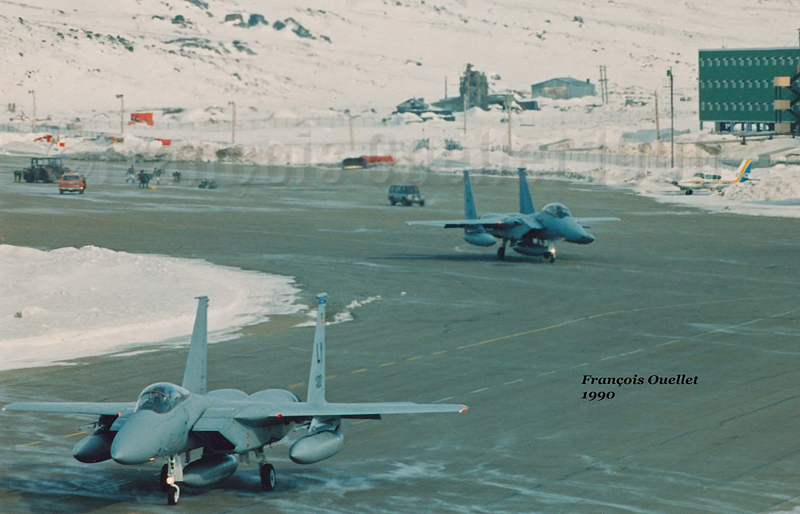
American F-15 landing in Iqaluit
The local Transport Canada flight service specialists (FSS) had to deal with the tight operating schedule provided by a military officer as well as integrate the daily arrivals and departures of private and commercial aircrafts.
At the time, the most useful taxiway, one which was located near the end of runway 35, could not be used since the terrain was too soft. All the aircrafts using runway 35 were forced to backtrack that runway before it could be cleared for other incoming or departing aircrafts. The additional time required for that procedure sometimes gave headaches to the military officer sitting by our side.
American F-15 Eagle airborne from Iqaluit
Canadian T-33s in Iqaluit (1990)
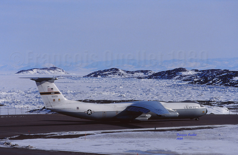
American Starlifter cargo aircraft ready for take-off in Iqaluit (1989)
I remember that the military officer in charge of the mission told us: “If the jets cannot takeoff within the next minute, the mission will be aborted”. It just happened that during the tight window within which the CF-18’s had to be airborne that day, there were many commercial aircrafts like the Avro 748, Twin Otter, Boeing 727 and 737 and other executive aircrafts operating around Iqaluit. There was always a way to please everybody and the military exercise ended the way it was initially planned.
Two Canadian CF-18s in Iqaluit (1989)
Two American F-15 Eagle taxiing for departure in Iqaluit (1990)
This was a period much appreciated by the flight service specialists (FSS) since, for one week during the year, our operations changed radically: we had to respect the imperative needs related to the military exercise as well as continue to provide regular air traffic services.
Six Canadian CF-18s, one Lockheed Electra Ice Patrol aircraft, a Dash-7 and a T-33 in Iqaluit
It was brought to our attention, for having discussed with many pilots involved in the exercise that military forces were kind enough to offer, through our Transport Canada manager, few posters signed by pilots of squadrons involved in the “Amalgam Chief” exercise. Although the manager never deemed necessary to show his staff even one of those posters, I appreciated the gesture from the pilots.
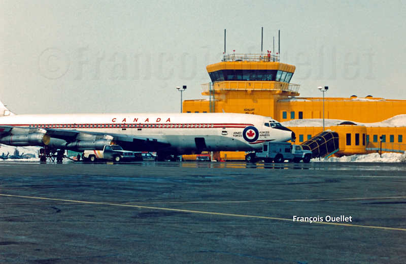
Canadian Armed Forces Boeing B-707 in Iqaluit, in front of the flight service station tower
1993. In order to replace a DEW line that had become obsolete, Canadians and Americans jointly built a new base that would now be used for logistical support for the new North Warning System.
Two Canadian fighter aircrafts CF-18 leaving the runway in Iqaluit.
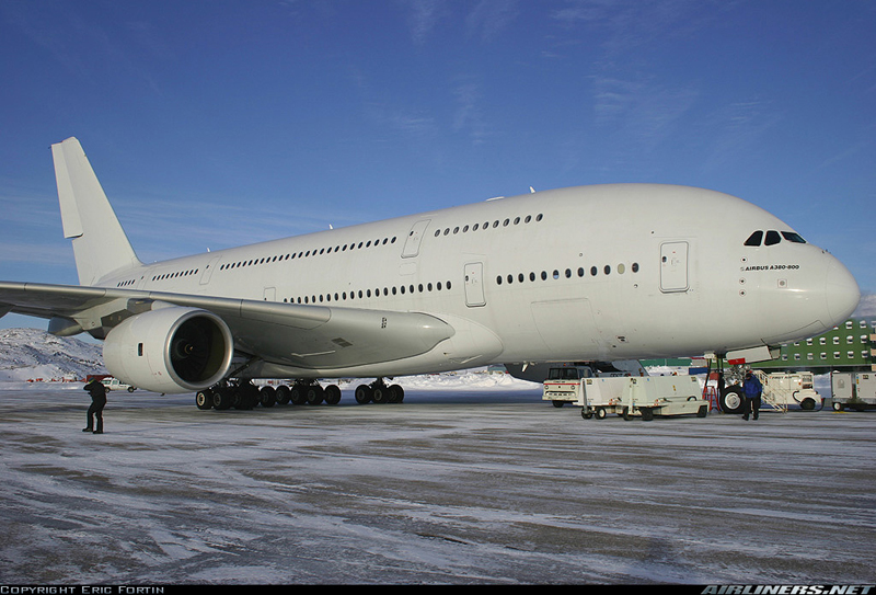
2006. Extreme cold tests were held in Iqaluit by Airbus for the A-380, the biggest passenger aircraft in the world.
Airbus A380-841 in Iqaluit, Canada, during cold weather testing
2014. Extreme cold tests were held by Airbus for its new A-350 XWB.
2015. Canada was the host of the Arctic Council Ministerial Meeting in Iqaluit. The Council is composed of the following countries: Canada, Sweden, Denmark, Finland, Iceland, Norway, Russia and United States. Joining the meeting were senior representatives of indigenous organisations holding the status of permanent participants.
Dassault completes several cold-soak trials in Iqaluit for its Falcon 6X
Pope Francis visits Iqaluit during his Canadian trip aimed at healing and reconciliation with Indigenous groups and residential school survivors.
2024. An Air France Boeing 797-900 makes an emergency landing in Iqaluit due to a burning smell reported by passengers.
(Next story: The military exercise “Amalgam Chief”: B-52 bombers in northern Canada)
Tales of a Dakota Pilot – The way it was 1929 – 1937
This is a simple and charming little book retelling the life stories of the pilot Fred Max Roberts Jr when he was flying his airplanes in the Bismark region, North Dakota, between 1929 and 1937. The book was written by his son, Fred Marke Roberts, so that some of his father’s stories do not fall in oblivion. You will find here a good idea of how things were done in the early years of aviation.
An original and easy way of refueling
When came the time to refuel, the pilots would regularly land on a farmer’s field. They knew that somebody had noticed the landing and, most of the time, a fuel truck would be sent without any previous arrangements. The pilot had nonetheless the duty to make sure he landed close to an easy access for the fuel truck. Sometimes, to simplify the refueling process a bit, the pilot landed directly on the road, outside of the city.
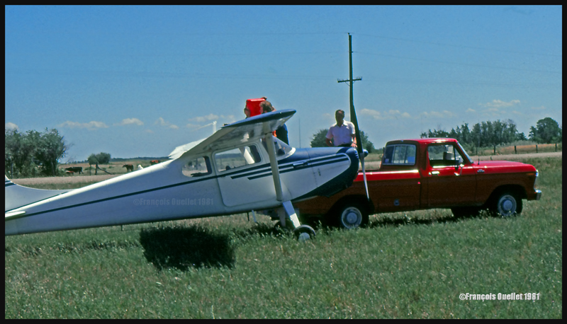
This habit did not seem to have change fifty years later when I did a 2650 kilometers cross-country flight with a Cessna 170B, between St-Jean-sur-Richelieu, Quebec, and Edmonton, Alberta. During the trip, I had to land in a field near Lundar, Manitoba, a Canadian province which is bounded to the south by North Dakota and Minnesota. Soon after the landing, a pick-up truck carrying fuel approached the plane. I had not made any arrangements for fuel. In my case, a precautionary landing was needed as the fuel gauges had started to give false indications. Since fuel was readily available, the tanks were topped before the next takeoff.
Landing in a field with a Cessna C170B in Lundar, Manitoba in 1981.
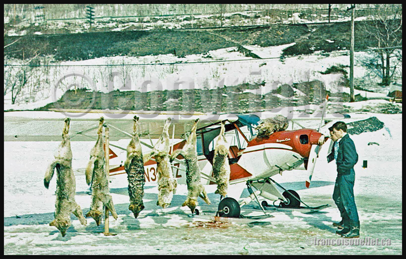
Killing coyotes against the county bounty
Coyotes where frequently attacking farmer’s livestock. When the situation was getting out of control, the farmers would phone Fred Max. The latter would take off with his Curtiss Junior Pusher, accompanied by an experienced shooter and they would spot and kill coyotes. Winter was the best season for hunting from the air since the coyote’s dark colored fur contrasted against the white snow.
The farmers, on their horses, were following the aircraft’s manoeuvers to spot where the coyotes had been shot. They then brought the dead animals back to their farm. Few minutes later, the aircraft would land as close to the farm as possible and the pilots picked up the coyotes, bringing them back to the county’s bureau in order to receive the published bounty for each killed coyote.
Super Cub and wolves shot from the air in Northern Ontario, Canada, on an aviation postcard dating from the sixties.
The American Midwest farmer’s hospitality
When a pilot landed in a farmer’s field, as a stopover on a long cross-country flight, he would often be offered a meal with the farmer’s family. If darkness was an obstacle for the continuation of the flight, the pilot was often offered a bed for the night. The next morning, after breakfast, and as a thank you gesture, the pilot would offer the farmer a courtesy flight.
A practical way to lower the costs associated with a long cross-country flight
An easy way to reduce the costs associated with a long cross-country flight was to offer airplane rides to villagers who had come to meet the pilot once at the destination. The pilot landed, waited a bit and knew that, soon, few people would come to him to ask for a ride.
The pilot Fred Max Roberts Jr hanging to the wing of his monoplane
A major concern for any pilot landing in a field was to find a fence to tie the plane as soon as possible to protect it from the strong winds blowing over the Midwest plains. But really strong gusts would sometimes break the ropes.
The pilot tells the reader that he was once immobilized in the middle of a field while a storm was quickly approaching. He got under the wing of his monoplane and hanged to it in order to add some weight. But that was not enough. A strong gust lifted the plane, broke the two tie-downs and sent pilot and plane flying at about ten feet in the air. Fearing that his plane would continue to climb without him at the controls, the pilot let go. The plane maintained a level flight while backing until it suddenly rolled and crashed.
Pilot and passengers are caught in flight by a tornado
Flying and meteorology manuals teach every pilot the necessity to avoid thunderstorms because, among other reasons, of the extreme ascending and descending air currents that are present in a well-developed cell. The pilot Fred Max Roberts Jr not only went through a thunderstorm but survived a tornado while he was in flight. His story was published in many newspapers at the time. Some of the articles are reproduced in the book.
As the pilot tells it, meteorological forecasts and weather observations were not as easily accessible as they are today. During a flight with passengers in his Waco 90 biplane, the sky suddenly darkened and the weather degraded rapidly. The pilot tried his best to fly between two important cloud formations. He could hardly see his instruments due to the lack of light, even if the flight was made during the day. He was fighting to avoid being disoriented.
Suddenly, the plane started to gain altitude rapidly by itself. The pilot nosed his ship downward and applied full power. This was useless. The aircraft was still rapidly climbing, tail first. Then the ascent abruptly stopped and a dive ensued. He pulled on the stick to bring his Waco to a level flight, but the rapid descent continued. Having no other choice, he applied full throttle and set his plane for a normal climb. Again, the descent continued until the Waco was at about 500 feet above ground level.
Eventually, they got out of the storm and landed at White Rock. Fred Max then realized that his passengers, sitting in the open cockpit Waco during the storm, had not fasten their seat belts and were hanging for dear life to a brace running across the front of the passenger cockpit.
Those are some of the tales a reader can find in “Tales of a Dakota Pilot”, an unpretentious book but nonetheless a publication that might very well surprise many young pilots, as the 1930’s way of flying so differed from what a young pilot lives when he integrates today’s world of aviation.
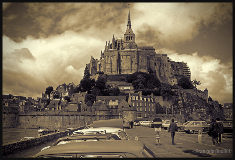
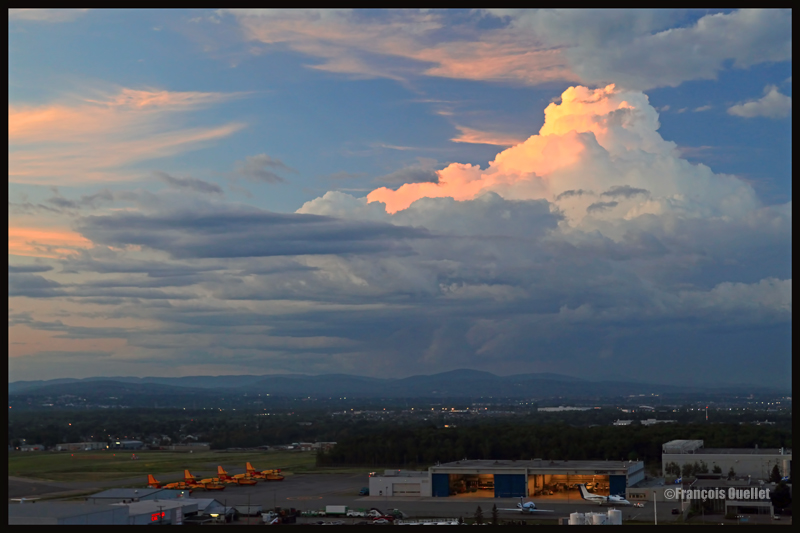
Cumuliform clouds add energy to any photo. Even photos in black and white benefit from them largely, whether it is for a normal or an HDR photo.
Cumuliform clouds add dynamism to this Abbaye du Mont St-Michel scenery. France (1978)
Black and white HDR picture of lamp posts installed along the St-Lawrence, Quebec City 2012.
The stratiform clouds add to the tranquillity and the stability of a photo.
Daytona Beach under stratus clouds in 2011. The end of the afternoon allows the fresh air from the sea to move over the heated land, which helps create few cumulus fractus, visible near the buildings.
Clouds including a stratiform and cumuliform components (stratocumulus) produce an effect that is more energizing than the simple stratus, while avoiding the explosion of energy of the cumuliform clouds.
A stratocumulus adds to this otherwise peaceful scenery captured on board the Lyria train between Paris and Geneva in 2013.
The cold front
The approach of a cold front enhances the possibility of interesting photos. If it is a fast moving cold front of moist and unstable air, the photos will probably be more spectacular, as some thunderstorms will be associated with the system. A dew point of more than 15 C indicates the presence of a lot of water vapor which can be transformed into precipitation, thus releasing a lot of energy. When these conditions are combined with a really strong contrast between the new air mass which approaches and the one which goes away, the produced meteorological phenomena will certainly be intense.
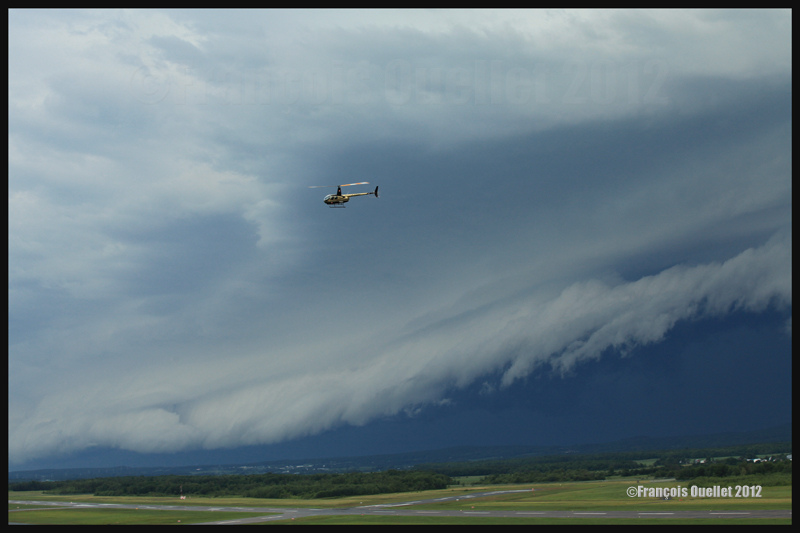
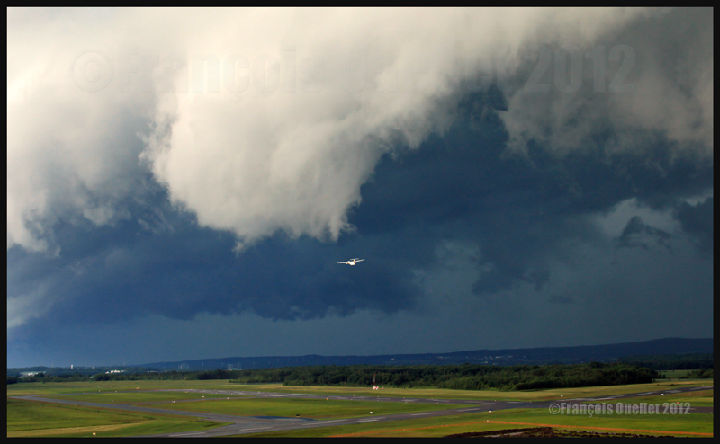
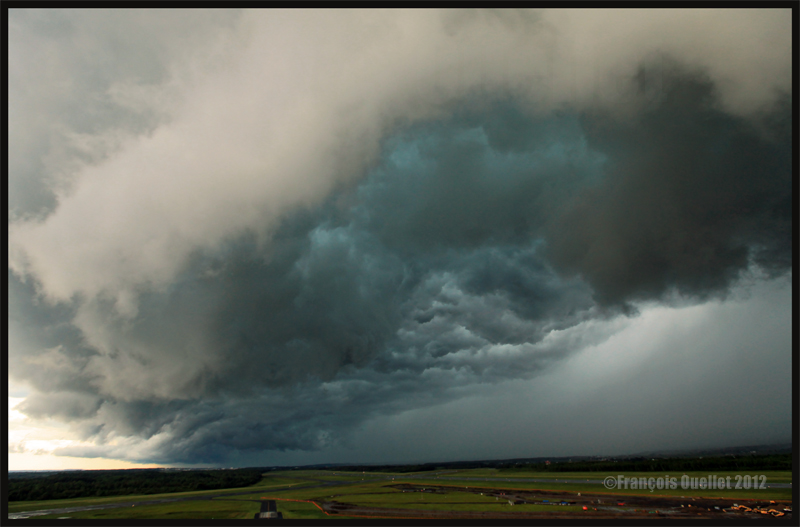
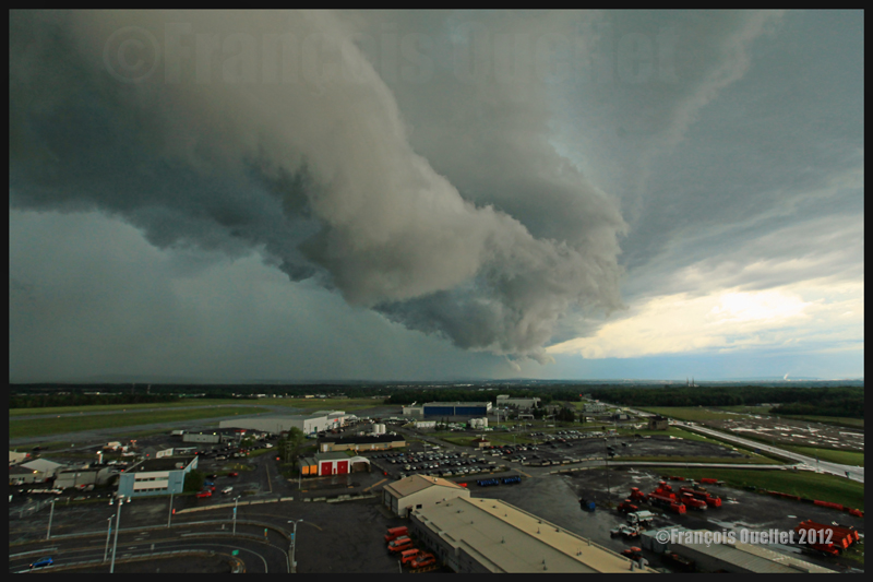
In the photos below, the meteorological system approaching the Quebec Jean-Lesage international airport also had to cross a small mountain range.
A roll arcus cloud in development ahead of a thunderstorm approaching the Quebec Jean-Lesage airport in 2012.
A roll arcus cloud in development ahead of a thunderstorm approaching the Quebec Jean-Lesage airport in 2012.
View under a developing arcus cloud at the Quebec Jean-Lesage international airport (2012)
An arcus cloud ahead of a thunderstorm approaching the Quebec Jean-Lesage airport in 2012
A roll arcus cloud ahead of a thunderstorm heading for Quebec City in 2012
The morning fog
The morning fog offers many opportunities for interesting photos. You can choose an isolated tree and capture the combined effects of the morning sun and fog. Or you may choose a cluster of trees, for a completely different effect. Both photos below were taken in Domaine Cataraqui, Quebec City.
Trees in fog at Domaine Cataraqui, Quebec City 2009
Sun and fog provide for a special atmosphere at the Domaine Cataraqui, Quebec City 2009
A morning fog resulting from a cold cloudless night will persist for hours if there is no wind. The cold morning air, motionless over a slightly hotter stretch of water, creates a fog that will finally disappear just before noon, when the atmosphere has been heated enough. If there had been an overcast sky during the night, chances are that the air over the water would have remained at a higher temperature, preventing the formation of fog.
The opportunities for more interesting photos arise when you witness the first holes in the fog layer.
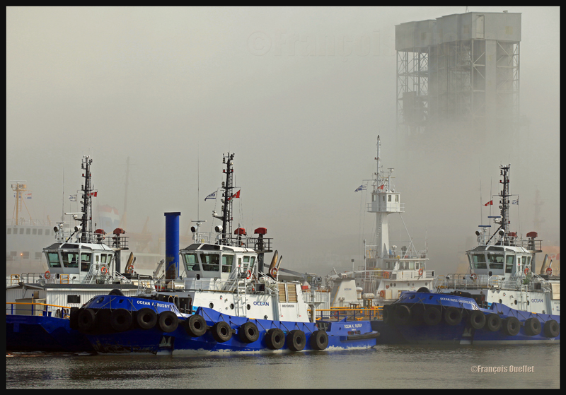
The Ocean tugboats during a dense fog in the Bassin Louise in Quebec (2012).
We can take into account the season to estimate the speed of the diurnal reheating of the lower atmosphere. A morning fog will need more time to dissipate from late autumn to early spring: that leaves more time for the photographer to prepare. The forecasts can announce the disappearance of fog while it will not be the case if, over your sector, there is an invading layer of stratocumulus preventing the morning sun from reaching the ground.
To determine if the fog is going to dissipate as expected or will remain and possibly intensify, watch the difference between the temperature and the dew point on the hourly meteorological observations issued by weather stations near your place of residence. If the temperature and dew point spread increases, the fog is going to lift. If the difference between those two decreases, the fog is going to persist and possibly intensify.
The mist
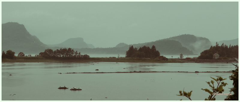
The mist can be qualified as such when the visibility is superior to ½ mile, but do not exceed 6 miles for an observer on the ground. If the visibility is of ½ mile or less, it is called fog. This photo of the Bic National Park, near Rimouski, shows the interesting effect that the mist adds to a beautiful landscape.
Mist in the Bic National Park, Province of Quebec (2009)
Hot and unstable air in winter
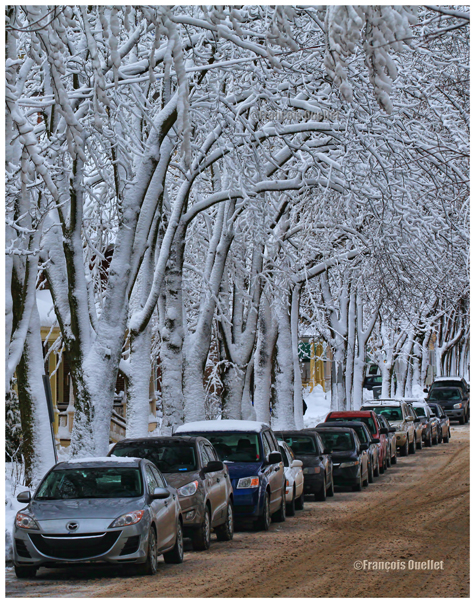
When there is a warm and unstable air advection (about 0 degrees) while winter has already settled, there are good opportunities for photos. A moderately developed cumulus produces significant snow showers and this snow sticks on all the surrounding objects. All that snow would have begun to melt on contact of objects if the latter had had a temperature superior to zero degree. But, the winter being already settled, the snow persists. It gives enough time to capture some souvenirs.
A Quebec City street after a snow shower
The local effects
A photographer might benefit from learning about the meteorological local effects influencing the regions he intends to visit. The local effects are often simple to understand and they repeat themselves regularly, according to wind and season changes. The knowledge of these effects allows the photographer to be ready and position himself even before the phenomenon occurs. It limits the comments like: “If I had known that it would occur, I would have settled down here one hour earlier!“
The local terrain as well as large size bodies of water produce predictable meteorological phenomenon that can be used by a well prepared photographer. It can consist of persistent fog, repetitive snowstorms over a small sector, strong winds, cumuliform clouds alongside the mountain summits, etc. By being positioned at the right place, at the right time, the desired photo can be realized.
A change in the wind direction
A change in the wind direction suddenly increases the opportunities of interesting photos. It might announce the approach of a cold front, a warm front, a sea or land breeze, etc. In the photo below, a bit of fresher air suddenly began crossing the St-Lawrence seaway at the end of the day, thanks to the approach of a weak cold front. The water was still relatively warm and the moisture which was present over the surface became visible due to the cool air supply. The conditions were now ideal for a short-term thin fog, as long as the wind speed would not increase. Just in time for a photo.
The new wood pellets silos in Anse au Foulon in Quebec City en 2014
Familiarization with weather radars
It can be useful to get acquainted with weather radars which, for the needs of photography, remain simple to interpret. Multiple echoes of small dimension with a steep gradient of various colors indicate precipitation resulting from cumuliform clouds. The showers associated with these clouds are often moderated or strong and will be the result of approaching towering cumulus or cumulonimbus (thunderstorms). A towering cumulus presents a dark base and a white summit to the photographer. At sunset, their vertical development can be used to emphasize the last rays of light.
The side of a towering cumulus (TCU) is benefiting from the remaining sunlight over Quebec
Large echo areas of similar colors of low intensity indicate a relatively stable air generally producing steady light rain or drizzle. This should be understood as a possibility of increased humidity limiting the visibility through mist or fog.
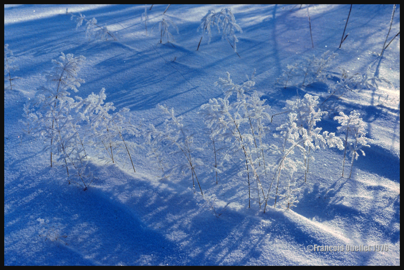
Hoar frost
Hoar frost is a short-term phenomenon. It is thus necessary to capture the scene before the sun melts everything. The photo below shows some small twigs on which hoar frost has settled. It was taken at the beginning of the seventies. Although the quality of the photo is not exceptional, the meteorological phenomenon is well demonstrated.
A combination of snow and hoar frost observed on a Quebec field in 1976.
Forest fires
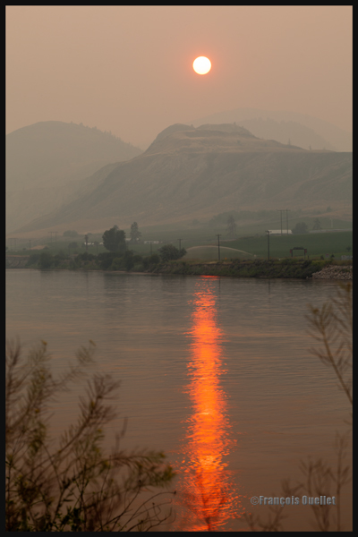
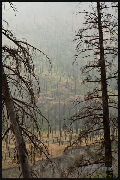
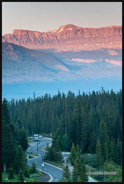
Wishing to make photos of western Canada during summer 2014, I came up against a season where hundreds of forest fires were raging. The smoke was covering some parts of Alberta and British Columbia. Some fires were important enough to require the closure of the sole highway connecting Lake Louise to Jasper. I thus decided to include the effects of those fires in the holiday souvenirs.
A visibility reduced in forest fire smoke allows a photographer to obtain, without special editing, sunsets with interesting colors.
Sunset and smoke from forest fires in Kamloops in 2014
The smoke also produces an effect similar as fog, but a fog which would be impossible to obtain at the end of a summer afternoon while the sun shines and there is a 38 degrees Celsius temperature.
An area near Kamloops, Canada, that was touched by forest fires in 2014
At dusk, the residual smoke is visible near tree tops while the setting sun strikes the mountain side. The effect is of two horizontal lines of complementary colors, blue and orange.
Forest fire smoke and sunset combined in Lake Louise, Alberta en 2014