Leaving Tadoussac, the road continues along the Côte-Nord (North Shore) and we pass through Forestville to reach Baie-Comeau and take the ferry to Matane, on the south shore of the St. Lawrence River.
We arrive in Matane at dusk, just in time to set up the camera equipment on the beach. There’s no way I can take the photo above from the ferry, because a long exposure requires absolute stillness. I want to capture this beautiful September moon rising above the houses.
I miss a few shots by relying on autofocus. I quickly change my photography technique. Liveview (Live View) mode and manual focus will improve the sharpness.
Fishing boat at dusk in Matane, Quebec 2025
The next day, a boat leaves Matane just before nightfall for a fishing expedition off the St. Lawrence River. The relative calm of the waters offers interesting reflections. The low light and distance of the boat require the use of a high-quality lens, in this case the Canon EF 300mm f/2.8L IS II USM.
On the way back from Matane to Quebec City, a stop at Bic National Park allows us to take a few photos, including this fishing boat returning to port. The sailors’ departure time varies constantly depending on the river tides.
Fishing boat in the Parc national du Bic, Québec 2025
Another location well known for its beauty is the municipality of Sainte-Luce-sur-Mer. Below, the colorful houses along the beach attract the attention of tourists and contribute to the area’s reputation. I preferred to capture an overall effect by including vegetation in the foreground. The few small low cumulus clouds also add to the dynamic of the scene.
The village of Sainte-Luce-sur-Mer and its colorful houses.
One last photo shows the sunset in Berthier-sur-Mer. This area, along with the Kamouraska and Notre-Dame-du-Portage regions, regularly offers exceptional panoramas when the sun sets. So much so that some photos can look like they’ve been retouched.
I saw reds and purples so pronounced that it became obvious that the photographer would have been accused of oversaturating his shots.
Sunset at Berthier-sur-Mer en 2024.
After an excellent meal at the beach restaurant in Berthier-sur-Mer, we finally reach our final destination, the beautiful city of Quebec City.
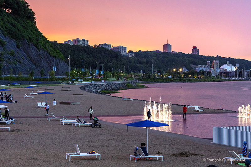
An evening after the rain at the Station de la plage, Québec 2024
A few Quebec City residents enjoy the last glimmers of daylight at the Station de la Plage, as the showers of the previous hour precipitated the departure of the other occupants.
Radar echoes showed towering cumulus clouds (TCU) approaching the area at around 19:00. These usually produce short-lived showers, letting light through here and there between the cloud formations.
For a photographer, the first ingredient in capturing a special sky is present.
The second prerequisite is that the setting sun’s rays travel a greater distance through the atmosphere, unblocked by a distant weather system. This makes it possible to observe such impressive shades of pink and red. So, we check the forecast to verify that this is no weather system coming the next day.
These two conditions greatly increase the chances of an interesting sky at dusk. It doesn’t always work, but let’s just say that planning improves the likelihood of a successful photo shoot.
That’s what happened on this August evening in 2024.
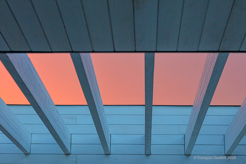
Evening sky visible through the installations at the Station de la plage, Québec 2024
The photo above shows the shades of sky visible through the openwork ceiling of the Station de la plage. I like the minimalist look. It vaguely reminds me of the paintings of Canadian NewfoundlanderChristopher Pratt. For him, the primary interest lies less in the representation of an architectural structure as such than in the addition of light that will transform the viewer’s perception.
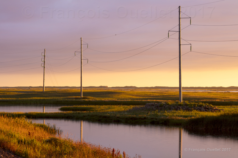
The Magdalen Islands, in the Province of Quebec, are recognized for the magnificent sunsets. The picture above was taken while I was coming back from Havre Aubert with my family during summer 2017. The ponds are located between Havre Aubert and Cap-aux-Meules, immediately alongside the main road.
The day had been cloudy and there was no indication that the evening would offer a possibility to get an interesting picture. But around 8 PM, while the sun was still relatively high above the horizon, a few sunrays were able to pierce through the cloud deck. The stratocumulus being well defined, it became obvious that when the sun would be close enough to the horizon, it would light the cloud deck from below as well as light up the ponds. It was important to act rapidly in order to capture the beautiful atmosphere.
When the winds are calm and you must stand still close to ponds in order to do photographic adjustments, one must accept to lose some blood to swarming moskitos. That night, I must have lost a pint of blood!
The absence of wind allowed for a good reflection of the electric poles in the foreground.
The picture was taken with a Canon 5DSR full frame camera equipped with a Canon 70-200 f2.8L IS II USM telephoto lens and a graduated filter used to avoid the underexposure that would be caused by the highlights in the horizon. I used aperture priority and set it at F18 to get a proper depth of field. The ISO was set at 200 and the focal length at 135 mm.
For other photos on the province of Quebec and also Quebec City, click on the following links from my blog:
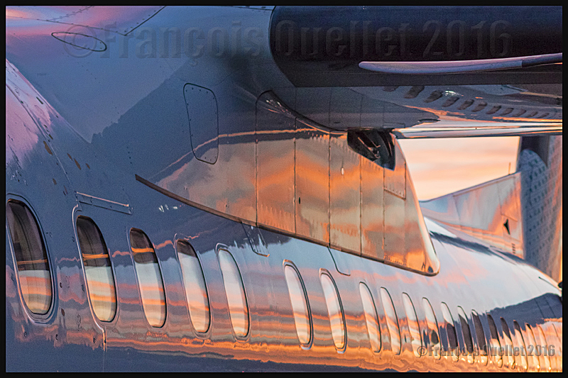
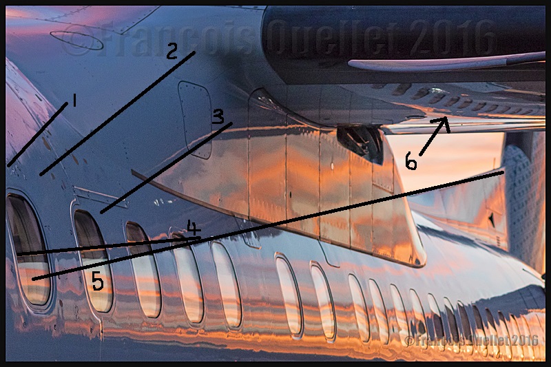
Sunset colors reflecting on an Air Canada Bombardier Q-400 in Toronto
The Air Canada Terminal installations at the Toronto Lester B. Pearson international airport are such that a voyager intending to do a flight from Toronto to Quebec has to walk outside the building to catch his plane. This has some advantages, especially when it is an evening flight and there is, at the time of boarding, a superb sunset.
But to directly photograph the sunset colors without any filter or tripod, while hand holding the camera, is a recipe for disaster. And a photographer cannot stay immobile for very long in that restricted area where security agents and passengers walking towards the DHC-8-400 demand that everyone move with the flow.
A practical method that offers very good results is to indirectly photograph the beautiful sunset colors by using the aircraft as a reflector.
First, it is better to use a camera lens that requires very little light. This will limit the grain size while allowing a shutter speed that is high enough to avoid a blurred picture. The scenery was thus captured with a Canon 5DSR full-frame camera equipped with a Canon EF 50mm f/1.4 USM lens.
Secondly, the photographer must crop the photography using an image editing software so that all useless details are absent from the final shot. There are two objectives: 1) it is obviously necessary to keep the aircraft parts that will best show the sunset colors and 2) do the best possible use of the elements presenting graphic interests for the viewer.
If I had kept only several oversized windows in order to show the superb sunset colours, there would have been only clear bright colours, without contrasts. That would have given an uninteresting photo. The advantages of protecting the shadowy top of the aircraft are that it adds a strong luminosity contrast, allows the inclusion of the Q-400 diagonal lines (1-2-3-4-5) and a reflection of the reflections themselves (6) under the aircraft’s wing. All this is highlighted in the photo below.
Photography theory: diagonal lines on a Bombardier Q-400 photo
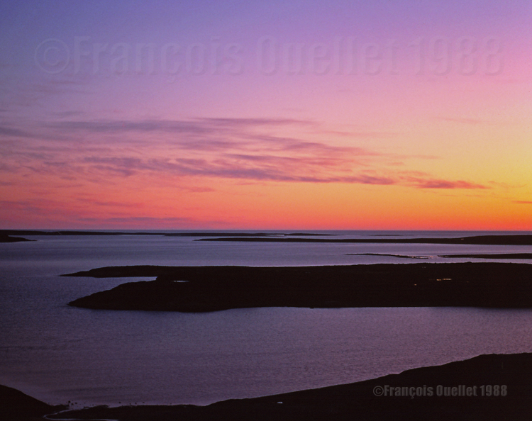
Colors of the sky during nightime. Summer 1988, Iqaluit.
Around 1989-1990, there was in Iqaluit, on Baffin Island, a very quiet Inuit living in the same eight floor building as I did. He spent his free time reading while walking, lost in his thoughts like a priest. When we crossed each other on the street, we always exchanged polite greetings.
One evening, as I was about to leave my apartment to go to work the night shift at the Transport Canada flight service station (FSS), I saw in the corridor a man who was really going through an anger crisis, shouting and using all his determination to destroy a wall with a hammer. He was really going at it and the work was moving ahead very well…
I recognized that person that I was greeting almost on a daily basis and I was now facing a problem: To go work at the FSS station, I had to walk very close to him, since there was no other issue out of the building. Was he in such a crisis that he would not remember me?
I got closer and took the chance to pass just behind him. He suddenly stopped hitting the wall, turned around with the hammer in his hand and looked at me. Then he calmly said, like the gentlemen that he usually was: “Good evening!” I replied then walked about ten meters toward the exit before I heard him shout and hit the wall again.
The least I can say is that, some nights, you could witness the most bizarre situations. And when that was preceding a night shift, in an isolated Arctic post, you sometimes had the feeling to be living in a surreal world.
I do not know how the story ended. The next morning, back from the night shift, I entered a building where everything was peaceful. The only trace left by the man in crisis was a damaged wall. Very soon, somebody would come and repair the wall and that event would rapidly be erased from memories.
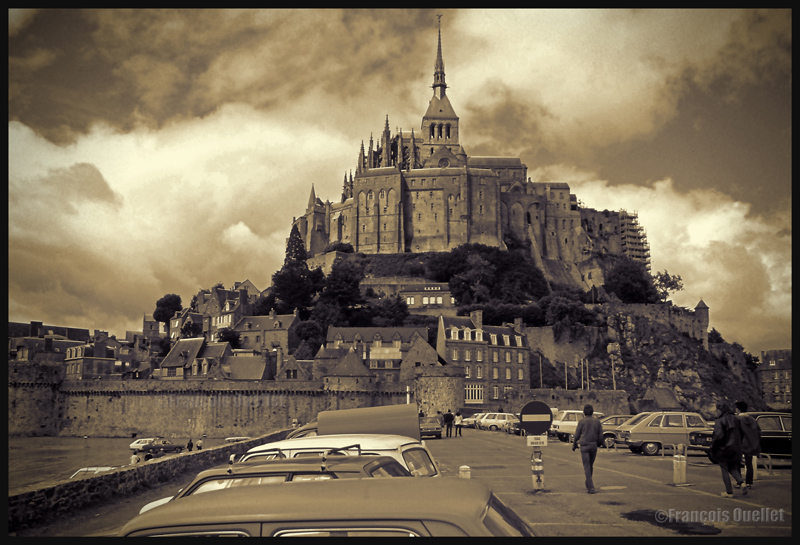
Cumuliform clouds add energy to any photo. Even photos in black and white benefit from them largely, whether it is for a normal or an HDR photo.
Cumuliform clouds add dynamism to this Abbaye du Mont St-Michel scenery. France (1978)
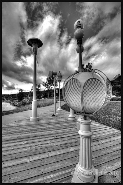
Black and white HDR picture of lamp posts installed along the St-Lawrence, Quebec City 2012.
The stratiform clouds add to the tranquillity and the stability of a photo.
Daytona Beach under stratus clouds in 2011. The end of the afternoon allows the fresh air from the sea to move over the heated land, which helps create few cumulus fractus, visible near the buildings.
Clouds including a stratiform and cumuliform components (stratocumulus) produce an effect that is more energizing than the simple stratus, while avoiding the explosion of energy of the cumuliform clouds.
A stratocumulus adds to this otherwise peaceful scenery captured on board the Lyria train between Paris and Geneva in 2013.
The cold front
The approach of a cold front enhances the possibility of interesting photos. If it is a fast moving cold front of moist and unstable air, the photos will probably be more spectacular, as some thunderstorms will be associated with the system. A dew point of more than 15 C indicates the presence of a lot of water vapor which can be transformed into precipitation, thus releasing a lot of energy. When these conditions are combined with a really strong contrast between the new air mass which approaches and the one which goes away, the produced meteorological phenomena will certainly be intense.
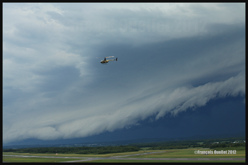
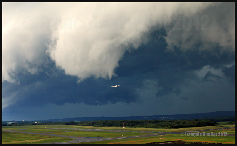
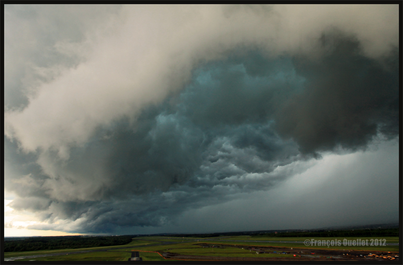
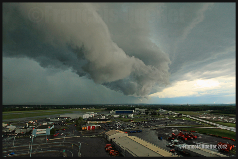
In the photos below, the meteorological system approaching the Quebec Jean-Lesage international airport also had to cross a small mountain range.
A roll arcus cloud in development ahead of a thunderstorm approaching the Quebec Jean-Lesage airport in 2012.
A roll arcus cloud in development ahead of a thunderstorm approaching the Quebec Jean-Lesage airport in 2012.
View under a developing arcus cloud at the Quebec Jean-Lesage international airport (2012)
An arcus cloud ahead of a thunderstorm approaching the Quebec Jean-Lesage airport in 2012
A roll arcus cloud ahead of a thunderstorm heading for Quebec City in 2012
The morning fog
The morning fog offers many opportunities for interesting photos. You can choose an isolated tree and capture the combined effects of the morning sun and fog. Or you may choose a cluster of trees, for a completely different effect. Both photos below were taken in Domaine Cataraqui, Quebec City.
Trees in fog at Domaine Cataraqui, Quebec City 2009
Sun and fog provide for a special atmosphere at the Domaine Cataraqui, Quebec City 2009
A morning fog resulting from a cold cloudless night will persist for hours if there is no wind. The cold morning air, motionless over a slightly hotter stretch of water, creates a fog that will finally disappear just before noon, when the atmosphere has been heated enough. If there had been an overcast sky during the night, chances are that the air over the water would have remained at a higher temperature, preventing the formation of fog.
The opportunities for more interesting photos arise when you witness the first holes in the fog layer.
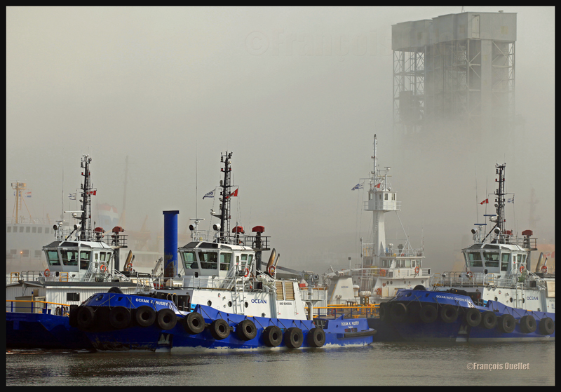
The Ocean tugboats during a dense fog in the Bassin Louise in Quebec (2012).
We can take into account the season to estimate the speed of the diurnal reheating of the lower atmosphere. A morning fog will need more time to dissipate from late autumn to early spring: that leaves more time for the photographer to prepare. The forecasts can announce the disappearance of fog while it will not be the case if, over your sector, there is an invading layer of stratocumulus preventing the morning sun from reaching the ground.
To determine if the fog is going to dissipate as expected or will remain and possibly intensify, watch the difference between the temperature and the dew point on the hourly meteorological observations issued by weather stations near your place of residence. If the temperature and dew point spread increases, the fog is going to lift. If the difference between those two decreases, the fog is going to persist and possibly intensify.
The mist
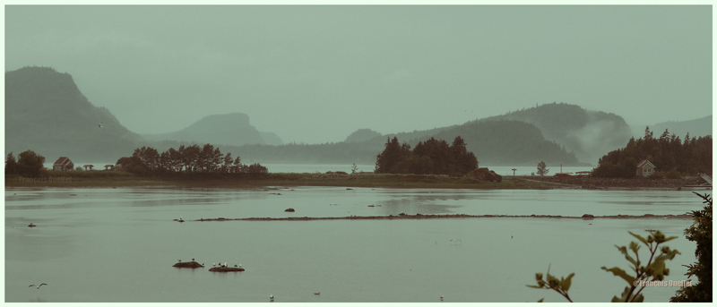
The mist can be qualified as such when the visibility is superior to ½ mile, but do not exceed 6 miles for an observer on the ground. If the visibility is of ½ mile or less, it is called fog. This photo of the Bic National Park, near Rimouski, shows the interesting effect that the mist adds to a beautiful landscape.
Mist in the Bic National Park, Province of Quebec (2009)
Hot and unstable air in winter
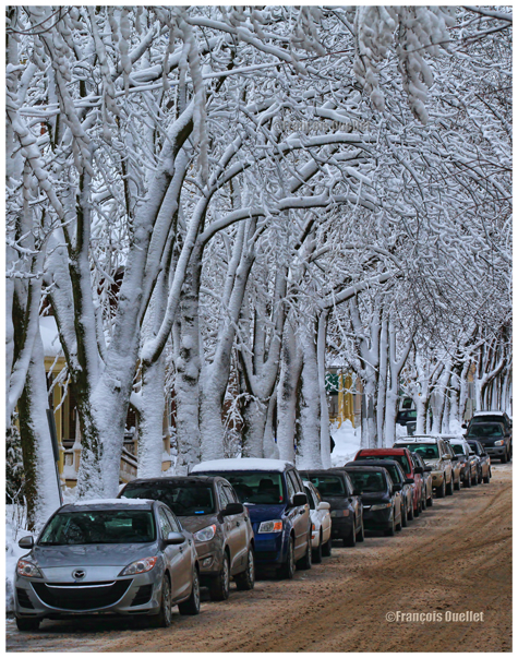
When there is a warm and unstable air advection (about 0 degrees) while winter has already settled, there are good opportunities for photos. A moderately developed cumulus produces significant snow showers and this snow sticks on all the surrounding objects. All that snow would have begun to melt on contact of objects if the latter had had a temperature superior to zero degree. But, the winter being already settled, the snow persists. It gives enough time to capture some souvenirs.
A Quebec City street after a snow shower
The local effects
A photographer might benefit from learning about the meteorological local effects influencing the regions he intends to visit. The local effects are often simple to understand and they repeat themselves regularly, according to wind and season changes. The knowledge of these effects allows the photographer to be ready and position himself even before the phenomenon occurs. It limits the comments like: “If I had known that it would occur, I would have settled down here one hour earlier!“
The local terrain as well as large size bodies of water produce predictable meteorological phenomenon that can be used by a well prepared photographer. It can consist of persistent fog, repetitive snowstorms over a small sector, strong winds, cumuliform clouds alongside the mountain summits, etc. By being positioned at the right place, at the right time, the desired photo can be realized.
A change in the wind direction
A change in the wind direction suddenly increases the opportunities of interesting photos. It might announce the approach of a cold front, a warm front, a sea or land breeze, etc. In the photo below, a bit of fresher air suddenly began crossing the St-Lawrence seaway at the end of the day, thanks to the approach of a weak cold front. The water was still relatively warm and the moisture which was present over the surface became visible due to the cool air supply. The conditions were now ideal for a short-term thin fog, as long as the wind speed would not increase. Just in time for a photo.
The new wood pellets silos in Anse au Foulon in Quebec City en 2014
Familiarization with weather radars
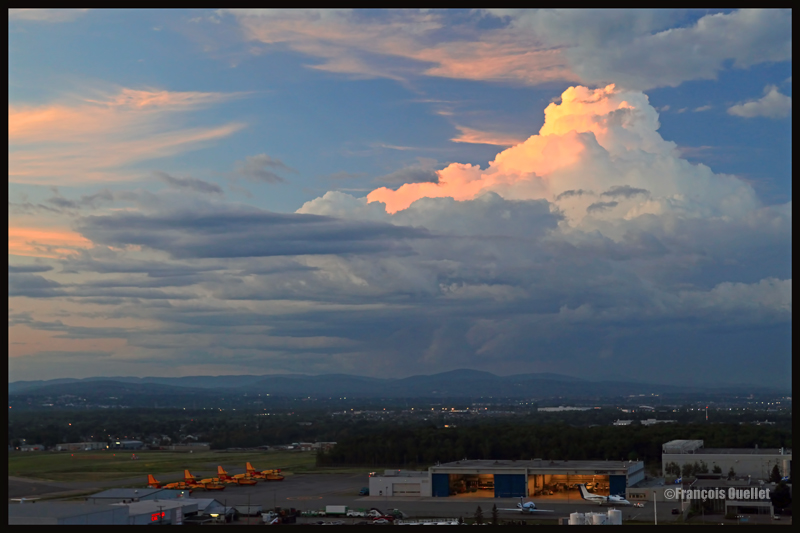
It can be useful to get acquainted with weather radars which, for the needs of photography, remain simple to interpret. Multiple echoes of small dimension with a steep gradient of various colors indicate precipitation resulting from cumuliform clouds. The showers associated with these clouds are often moderated or strong and will be the result of approaching towering cumulus or cumulonimbus (thunderstorms). A towering cumulus presents a dark base and a white summit to the photographer. At sunset, their vertical development can be used to emphasize the last rays of light.
The side of a towering cumulus (TCU) is benefiting from the remaining sunlight over Quebec
Large echo areas of similar colors of low intensity indicate a relatively stable air generally producing steady light rain or drizzle. This should be understood as a possibility of increased humidity limiting the visibility through mist or fog.
Hoar frost
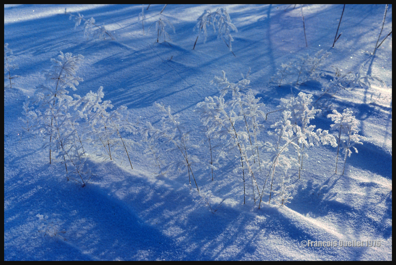
Hoar frost is a short-term phenomenon. It is thus necessary to capture the scene before the sun melts everything. The photo below shows some small twigs on which hoar frost has settled. It was taken at the beginning of the seventies. Although the quality of the photo is not exceptional, the meteorological phenomenon is well demonstrated.
A combination of snow and hoar frost observed on a Quebec field in 1976.
Forest fires
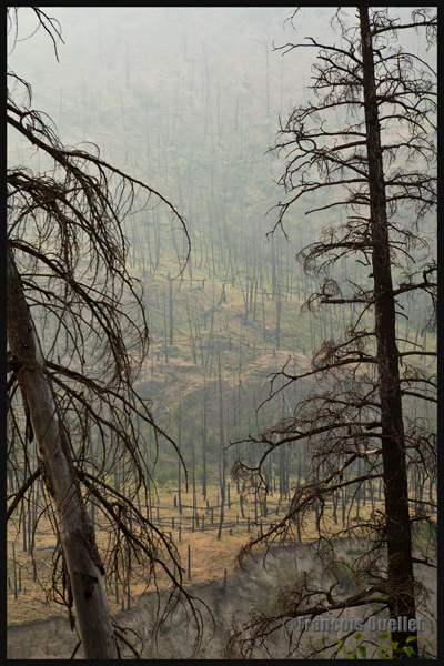
Wishing to make photos of western Canada during summer 2014, I came up against a season where hundreds of forest fires were raging. The smoke was covering some parts of Alberta and British Columbia. Some fires were important enough to require the closure of the sole highway connecting Lake Louise to Jasper. I thus decided to include the effects of those fires in the holiday souvenirs.
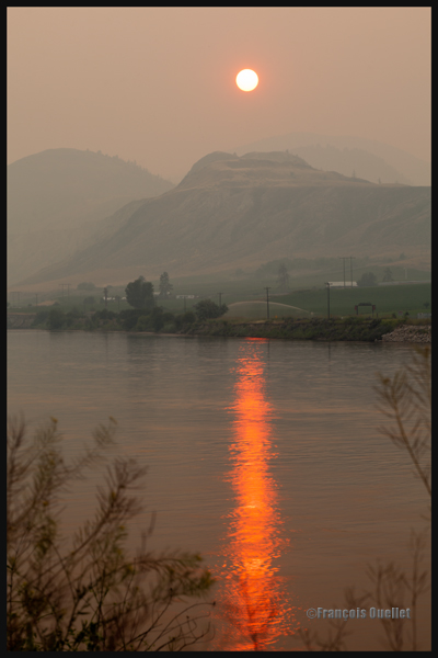
A visibility reduced in forest fire smoke allows a photographer to obtain, without special editing, sunsets with interesting colors.
Sunset and smoke from forest fires in Kamloops in 2014
The smoke also produces an effect similar as fog, but a fog which would be impossible to obtain at the end of a summer afternoon while the sun shines and there is a 38 degrees Celsius temperature.
An area near Kamloops, Canada, that was touched by forest fires in 2014
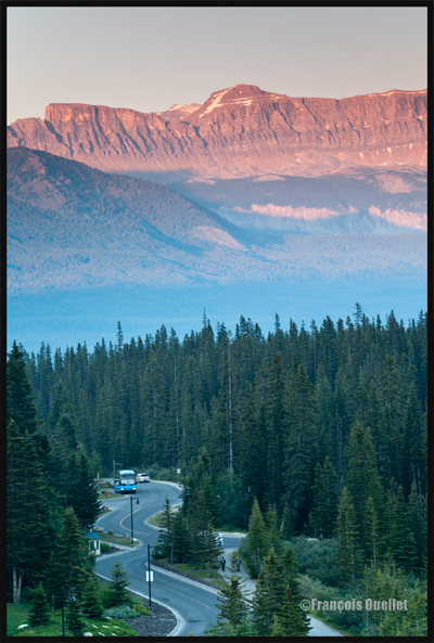
At dusk, the residual smoke is visible near tree tops while the setting sun strikes the mountain side. The effect is of two horizontal lines of complementary colors, blue and orange.
Forest fire smoke and sunset combined in Lake Louise, Alberta en 2014