Categories
Aviation Pioneers

Books : Our Transatlantic Flight.

Our transatlantic flight, by Sir John Alcock and Sir Arthur Whitten Brown

Newfoundland

Before 1949, Newfoundland was called Dominion of Newfoundland   and was part of the British Commonwealth . In 1949, it became a Canadian province.

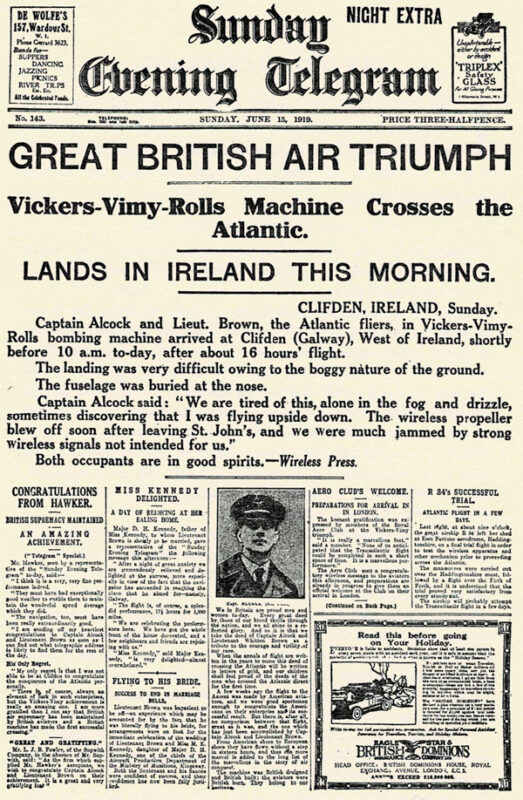
The first non-stop flight eastward across the Atlantic.

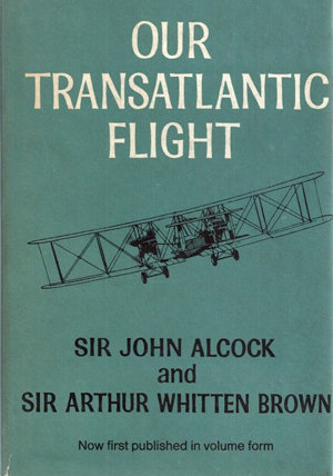
The book « Our transatlantic flight » tells the story of the historic flight that was made in 1919, just after the First World War, from Newfoundland to Ireland. There was a 10,000 £ prize offered by Lord Northcliffe   from Great Britain for whoever would succeed on the first non-stop flight eastward across the Atlantic.

A triumph for British aviation

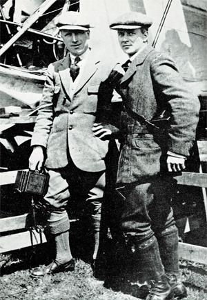
Sir John Alcock and Sir Arthur Whitten Brown , respectively pilot and navigator, wrote the story of their successful flight in this book which was published in 1969. The followings are pilot quotes from the book : « For the first time in the history of aviation the Atlantic had been crossed in direct, non-stop flight in the record time of 15 hours, 57 minutes. » (p.13) « The flight was a triumph for British aviation; the pilot and navigator were both British, the aircraft was a Vickers-Vimy   and the twin engines were made by Rolls-Royce. » (p.13)

Sir John Alcock and Sir Arthur Whitten Brown

As with all great human achievements, a very good flight planning and some luck was needed to make this flight a success. If there was an engine failure during the flight, even if the planning was excellent, there was only one outcome : downward.

In order to make the flight, Alcock and Brown boarded a ship from England bound to Halifax. They then headed to Port aux Basques and finally arrived in St.John’s. There, they joined a small group of British aviators who had arrived a few days before and who were also preparing for the competition. « The evenings were mostly spent in playing cards with the other competitors at the Cochrane Hotel, or in visits to the neighbouring film theatres. St.John’s itself showed us every kindness. » (p.60)

Maritime transport was used to carry the Vickers-Vimy biplane to Newfoundland on May 4th. It was assembled in Newfoundland. « The reporters representing the Daily Mail, the New York Times, and the New York World were often of assistance when extra manpower was required. » (p.61).

While the aircraft was being built, there were more and more visiters coming to the site. Brown says : « Although we remained unworried so long as the crowd contented itself with just watching, we had to guard against petty damage. The testing of the fabric’s firmness with the point of an umbrella was a favourite pastime of the spectators […]. » (p.61)

The Vickers-Vimy is being reassembled at Quidi Vidi in Newfoundland.

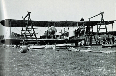
It was difficult to find a field that could be improvised into an aerodrome : « Newfoundland is a hospitable place, but its best friends cannot claim that it is ideal for aviation. The whole of the island has no ground that might be made into a first-class aerodrome. The district around St.John’s is  especially difficult. Some of the country is wooded, but for the most part it shows a rolling, switchback surface, across which aeroplanes cannot taxi with any degree of smoothness. The soil is soft and dotted with boulders, as only a light layer covers the rock stratum. Another handicap is the prevalence of thick fogs, which roll westward from the sea. » (p.59)

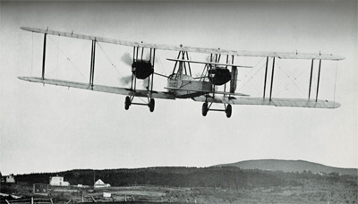
They flight tested the airplane on June 9th at Quidi Vidi. During the short flight, the crew could see icebergs near the coast. They did a second trial on June 12th and found that the transmitter constantly caused problems. But, at least, the engines seemed to be reliable…

The departure

The two men left Newfoundland on June 14th 1919. In order to fight the cold air in flight, they wore electrically heated clothing. A battery located between two seats provided for the necessary energy.

The Vickers-Vimy departs from Newfoundland in 1919

The short take-off was very difficult due to the wind and the rough surface of the aerodrome. Brown writes : « Several times I held my breath, from fear that our under-carriage would hit a roof or a tree-top. I am convinced that only Alcock’s clever piloting saved us from such an early disaster. » (p.73)

It took them 8 minutes to reach 1000 ft. Barely one hour after departure and once over the ocean, the generator broke and the flight crew was cut off from all means of communication.

As the airplane consumed petrol, the centre of gravity changed and since there was no trim on the machine, the pilot had to exert a permanent backward pressure on the joystick.

Flying in clouds, fog and turbulence.

During the flight with much clouds and fog, Brown, having almost no navigation aid,  had real problems to estimate the aircraft’s position and limit the flying errors. He had to wait for a higher altitude and for the night to come to improve his calculations : « I waited impatiently for the first sight of the moon, the Pole Star and other old friends of every navigator. » (p.84). The fog and clouds were so thick that at times they « cut off from view parts of the Vickers-Vimy. » (p.95)

Without proper instruments to fly in clouds, they were relying on a « revolution-counter » to establish the climbing or the falling rate. That is pretty scary. « A sudden increase in revolutions would indicate that the plane was diving; a sudden loss of revs  would show that she was climbing dangerously steeply. » (p.176)

But that was not enough. They also had to deal with turbulence that rocked the plane while they could not see anything outside. They became desoriented : « The airspeed indicator failed to register, and bad bumps prevented me from holding to our course. From side to side rocked the machine, and it was hard to know in what position we really were. A spin was the inevitable result. From an altitude of 4,000 feet we twirled rapidly downward.[…]. « Apart from the changing levels marked by aneroid, only the fact that our bodies were pressed tightly against the seats indicated that we were falling. How and at what angle we were falling, we knew not. Alcock tried to centralise the controls, but failed because we had lost all sense of what was central. I searched in every direction for an external sign, and saw nothing but opaque nebulousness. » (p.88)

« It was a tense moment for us, and when at last we emerged from the fog we were close down over the water at an extremely dangerous angle. The white-capped waves were rolling along too close to be comfortable, but a quick glimpse of the horizon enabled me to regain control of the machine. » (p.40).

De-icing a gauge installed outside of the cockpit.

Snow and sleet were falling. They didn’t realize how lucky they were to continue flying in such a weather. Nowadays, there are many ways to dislodge ice from a wing while the aircraft is in flight. Here is what Brown says about their situation : « […] The top sides of the plane were covered completely by a crusting of frozen sleet. The sleet imbedded itself in the hinges of the ailerons and jammed them, so that for about an hour the machine had scarcely any lateral control. Fortunately, the Vickers-Vimy possesses plenty of inherent lateral stability; and, as the rudder controls were never clogged by sleet, we were able to hold to the right direction. » (p.95)

After twelve hours of flying, the glass of a gauge outside the cockpit became obscured by clotted snow. Brown had to deal with it, while Alcock was flying. «  The only way to reach it was by climbing out of the cockpit and kneeling on top of the fuselage, while holding a strut for the maintenance of balance. […] The violent rush of air, which tended to push me backward, was another discomfort. […] Until the storm ended, a repetition of this performance, at fairly frequent intervals, continued to be necessary. » (p.94)

In order to save themselves, they executed a descent from 11,000 to 1000 feet and in the warmer air the ailerons started to operate again. As they continued their descent below 1000 feet over the ocean, they were still surrounded by fog. They had to do some serious low altitude flying : « Alcock was feeling his way downward gently and alertly, not knowing whether the cloud extended to the ocean, nor at what moment the machine’s undercarriage might touch the waves. He had loosened his safety belt, and was ready to abandon ship if we hit the water […]. » (p.96)

The arrival.

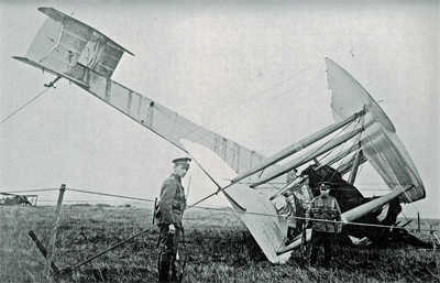
They saw Ireland at 8.15 am on June 15th and crossed the coast ten minutes later. They did not expect a very challenging landing as the field looked solid enough to support an aircraft. They landed at 8 :40 am at Clifden on top of what happened to be a bog; the aircraft rolled on its nose and suffered serious material damages. The first non-stop transatlantic flight ended in a crash. Both both crewmen were alive and well, although they were dealing with fatigue

The transatlantic flight ends up in Ireland in a soft field

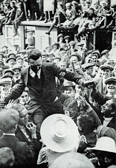
Initially, nobody in Ireland believed that the plane arrived from North America. But when they saw mail-bags from Newfoundland, there were « cheers and painful hand-shakes » (p.102).

First page of the Sunday Evening Telegraph in 1919.

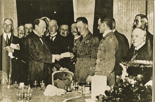
They were cheered by the crowds in Ireland and England and received their prize from Winston Churchill.

John Alcock chaired by the crowd
Winston Churchill is presenting the Daily Mail Check to the two pilots.

Their record stood unchallenged for eight years until Lindbergh’s flight in 1927.

The future of transatlantic flight.

Towards the end of the book, the authors risk a prediction on the future of transatlantic flight. But aviation made such a progress in a very short time that, inevitably, their thoughts on the subject was obsolete in a matter of a few years. Here are some examples :

« Nothwithstanding that the first two flights across the Atlantic were made respectively by a flying boat and an aeroplane, it is evident that the future of transatlantic flight belongs to the airship. » (p.121)

« […] The heavy type of aeroplane necessary to carry an economical load for long distances would not be capable of much more than 85 to 90 miles an hour. The difference between this and the present airship speed of 60 miles an hour would be reduced by the fact that an aeroplane must land at intermediate stations for fuel replenishment. » (p.123)

« It is undesirable to fly at great heights owing to the low temperature; but with suitable provision for heating there is no reason why flying at 10,000 feet should not be common. » (p.136)

The Air Age.

There is a short section in the book on the « Air Age ». I chose two small excerpts on Germany and Canada :

On Germany’s excellent Zeppelins : « The new type of Zeppelin – the Bodensee –  is so efficient that no weather conditions, except a strong cross-hangar wind, prevents it from making its daily flight of 390 miles between Friedrichshafen and Staalsen, thirteen miles from Berlin. » (p.140)

On Canada’s use of aeroplanes : « Canada has found a highly successful use for aeroplanes in prospecting the Labrador timber country. A group of machines returned from an exploration with valuable photographs and maps of hundreds of thousands of pound’s worth of forest land. Aerial fire patrols, also, are sent out over forests.» (p.142) and « Already, the Canadian Northwest Mounted Police [today the RCMP] have captured criminals by means of aeroplane patrols. » (p.146)

Conclusion

The Manchester Guardian stated, on June 16th 1919 : « […] As far as can be foreseen, the future of air transport over the Atlantic is not for the aeroplane. It may be used many times for personal feats of daring. But to make the aeroplane safe enough for business use on such sea routes we should have to have all the cyclones of the Atlantic marked on the chart, and their progress marked in from hour to hour. »(p.169)

Title : Our Transatlantic Flight

Authors : Sir John Alcock and Sir Arthur Whitten Brown

Edition : William Kimber

© 1969

SBN : 7183-0221-4

For other articles on that theme on my website: Aviation pioneers.

Categories
Photography

Photography and weather

Photography and weather

Some cloud families

Cumuliform clouds add energy to any photo. Even photos in black and white benefit from them largely, whether it is for a normal or an HDR photo.

Cumuliform clouds add dynamism to this Abbaye du Mont St-Michel scenery. France (1978)


Black and white HDR picture of lamp posts installed along the St-Lawrence, Quebec City 2012.

The stratiform clouds add to the tranquillity and the stability of a photo.

Daytona Beach under stratus clouds in 2011. The end of the afternoon allows the fresh air from the sea to move over the heated land, which helps create few cumulus fractus, visible near the buildings.

Clouds including a stratiform and cumuliform components (stratocumulus) produce an effect that is more energizing than the simple stratus, while avoiding the explosion of energy of the cumuliform clouds.

A stratocumulus adds to this otherwise peaceful scenery captured on board the Lyria train between Paris and Geneva in 2013.


The cold front

The approach of a cold front enhances the possibility of interesting photos. If it is a fast moving cold front of moist and unstable air, the photos will probably be more spectacular, as some thunderstorms will be associated with the system. A dew point of more than 15 C indicates the presence of a lot of water vapor which can be transformed into precipitation, thus releasing a lot of energy. When these conditions are combined with a really strong contrast between the new air mass which approaches and the one which goes away, the produced meteorological phenomena will certainly be intense.

In the photos below, the meteorological system approaching the Quebec Jean-Lesage international airport also had to cross a small mountain range.


A roll arcus cloud in development ahead of a thunderstorm approaching the Quebec Jean-Lesage airport in 2012.


A roll arcus cloud in development ahead of a thunderstorm approaching the Quebec Jean-Lesage airport in 2012.


View under a developing arcus cloud at the Quebec Jean-Lesage international airport (2012)


An arcus cloud ahead of a thunderstorm approaching the Quebec Jean-Lesage airport in 2012


A roll arcus cloud ahead of a thunderstorm heading for Quebec City in 2012


The morning fog

The morning fog offers many opportunities for interesting photos. You can choose an isolated tree and capture the combined effects of the morning sun and fog. Or you may choose a cluster of trees, for a completely different effect. Both photos below were taken in Domaine Cataraqui, Quebec City.

Trees in fog at Domaine Cataraqui, Quebec City 2009


Sun and fog provide for a special atmosphere at the Domaine Cataraqui, Quebec City 2009

A morning fog resulting from a cold cloudless night will persist for hours if there is no wind. The cold morning air, motionless over a slightly hotter stretch of water, creates a fog that will finally disappear just before noon, when the atmosphere has been heated enough. If there had been an overcast sky during the night, chances are that the air over the water would have remained at a higher temperature, preventing the formation of fog.

The opportunities for more interesting photos arise when you witness the first holes in the fog layer.

The Ocean tugboats during a dense fog in the Bassin Louise in Quebec (2012).

We can take into account the season to estimate the speed of the diurnal reheating of the lower atmosphere. A morning fog will need more time to dissipate from late autumn to early spring: that leaves more time for the photographer to prepare. The forecasts can announce the disappearance of fog while it will not be the case if, over your sector, there is an invading layer of stratocumulus preventing the morning sun from reaching the ground.

To determine if the fog is going to dissipate as expected or will remain and possibly intensify, watch the difference between the temperature and the dew point on the hourly meteorological observations issued by weather stations near your place of residence. If the temperature and dew point spread increases, the fog is going to lift. If the difference between those two decreases, the fog is going to persist and possibly intensify.


The mist

The mist can be qualified as such when the visibility is superior to ½ mile, but do not exceed 6 miles for an observer on the ground. If the visibility is of ½ mile or less, it is called fog. This photo of the Bic National Park, near Rimouski, shows the interesting effect that the mist adds to a beautiful landscape.

Mist in the Bic National Park, Province of Quebec (2009)


Hot and unstable air in winter

When there is a warm and unstable air advection (about 0 degrees) while winter has already settled, there are good opportunities for photos. A moderately developed cumulus produces significant snow showers and this snow sticks on all the surrounding objects. All that snow would have begun to melt on contact of objects if the latter had had a temperature superior to zero degree. But, the winter being already settled, the snow persists. It gives enough time to capture some souvenirs.

A Quebec City street after a snow shower


The local effects

A photographer might benefit from learning about the meteorological local effects influencing the regions he intends to visit. The local effects are often simple to understand and they repeat themselves regularly, according to wind and season changes. The knowledge of these effects allows the photographer to be ready and position himself even before the phenomenon occurs. It limits the comments like: “If I had known that it would occur, I would have settled down here one hour earlier!

The local terrain as well as large size bodies of water produce predictable meteorological phenomenon that can be used by a well prepared photographer. It can consist of persistent fog, repetitive snowstorms over a small sector, strong winds, cumuliform clouds alongside the mountain summits, etc. By being positioned at the right place, at the right time, the desired photo can be realized.

A change in the wind direction

A change in the wind direction suddenly increases the opportunities of interesting photos. It might announce the approach of a cold front, a warm front, a sea or land breeze, etc. In the photo below, a bit of fresher air suddenly began crossing the St-Lawrence seaway at the end of the day, thanks to the approach of a weak cold front. The water was still relatively warm and the moisture which was present over the surface became visible due to the cool air supply. The conditions were now ideal for a short-term thin fog, as long as the wind speed would not increase. Just in time for a photo.


The new wood pellets silos in Anse au Foulon in Quebec City en 2014


Familiarization with weather radars

It can be useful to get acquainted with weather radars which, for the needs of photography, remain simple to interpret. Multiple echoes of small dimension with a steep gradient of various colors indicate precipitation resulting from cumuliform clouds. The showers associated with these clouds are often moderated or strong and will be the result of approaching towering cumulus or cumulonimbus (thunderstorms). A towering cumulus presents a dark base and a white summit to the photographer. At sunset, their vertical development can be used to emphasize the last rays of light.


The side of a towering cumulus (TCU) is benefiting from the remaining sunlight over Quebec

Large echo areas of similar colors of low intensity indicate a relatively stable air generally producing steady light rain or drizzle. This should be understood as a possibility of increased humidity limiting the visibility through mist or fog.


Hoar frost

Hoar frost is a short-term phenomenon. It is thus necessary to capture the scene before the sun melts everything. The photo below shows some small twigs on which hoar frost has settled. It was taken at the beginning of the seventies. Although the quality of the photo is not exceptional, the meteorological phenomenon is well demonstrated.


A combination of snow and hoar frost observed on a Quebec field in 1976.


Forest fires

Wishing to make photos of western Canada during summer 2014, I came up against a season where hundreds of forest fires were raging. The smoke was covering some parts of Alberta and British Columbia. Some fires were important enough to require the closure of the sole highway connecting Lake Louise to Jasper. I thus decided to include the effects of those fires in the holiday souvenirs.

A visibility reduced in forest fire smoke allows a photographer to obtain, without special editing, sunsets with interesting colors.

Sunset and smoke from forest fires in Kamloops in 2014

The smoke also produces an effect similar as fog, but a fog which would be impossible to obtain at the end of a summer afternoon while the sun shines and there is a 38 degrees Celsius temperature.

An area near Kamloops, Canada, that was touched by forest fires in 2014

At dusk, the residual smoke is visible near tree tops while the setting sun strikes the mountain side. The effect is of two horizontal lines of complementary colors, blue and orange.

Forest fire smoke and sunset combined in Lake Louise, Alberta en 2014

Metar decode and description

Metar Decode and Description

Significant Present Weather Codes

Significant Present Weather Codes