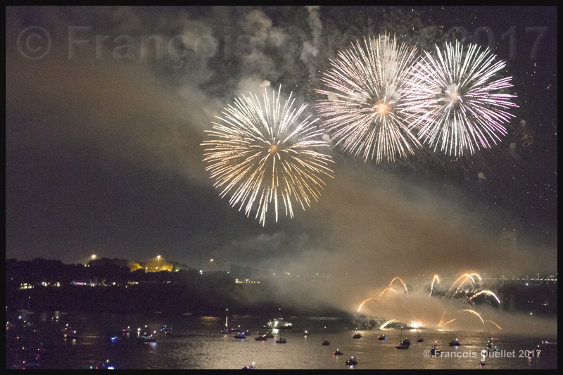
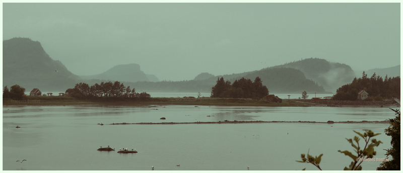
The Quebec Bridge, the longest cantilever type bridge in the world, celebrated its 100th anniversary in 2017. For the occasion, several activities were organized in Quebec on September 23rd 2017, culminating with fireworks near the bridge.
Reflections on the St. Lawrence Seaway. The 100th anniversary of the Quebec Bridge was celebrated with fireworks.
Several workers lost their live while attempting to build the bridge. A Wikipedia article resumes its history: The Quebec Bridge
In 2017, the safety issue was brought back in the news. This time it was about the lack of maintenance that favored an increasing amount of rust on the metallic structure.
The funds that would allow to paint the bridge on a regular basis seems hard to find. The bridge owner, the Canadian National Railway Company, and the different levels of government are attempting to find a solution that would be acceptable for all. This discussion has been going on for years. While the bridge holds on, everything is fine.
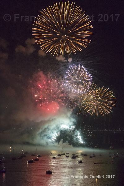
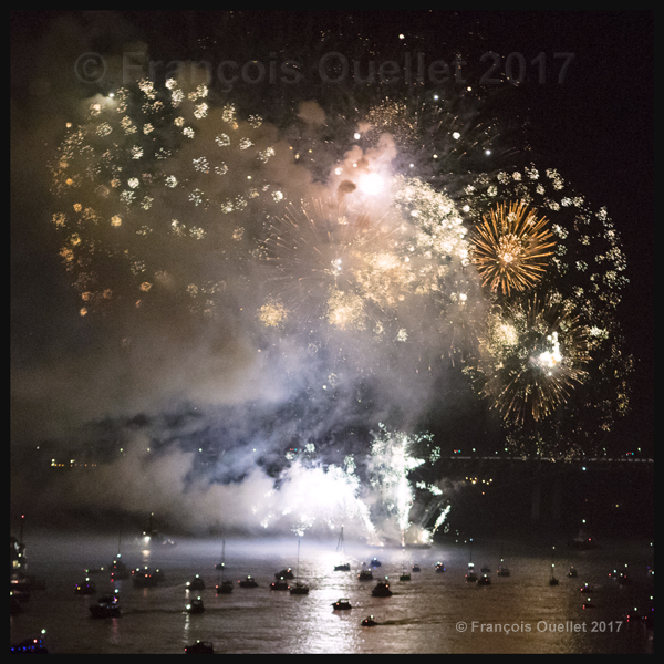
September 23rd 2017 celebration for the 100th anniversary of the Quebec Bridge.
About the photography
During the fireworks several boats equipped with an additional lighting system approached the bridge.
It was impossible to get really sharp shots of the boats since they were constantly moving due to the strong current of the St. Lawrence Seaway.
The fireworks lasted about thirty minutes and attracted a huge crowd, both along the St.Lawrence Seaway and on the higher grounds of bothLévis and Quebec City.
Fireworks for the 100th anniversary of the Quebec Bridge
Frequent adjustments of the camera’s aperture and ISO were needed since it is always very demanding for a camera to deal with sudden burst of lights appearing in the darkness. It was necessary to limit the exposure time in order to avoid an accumulation of blurred light trails.
The Quebec Bridge is 100 years old in 2017
The pictures were taken with a Canon 5DSR full frame camera mounted on a tripod. A Canon EF 24-70mm f/2.8L USM was used to capture the fireworks.
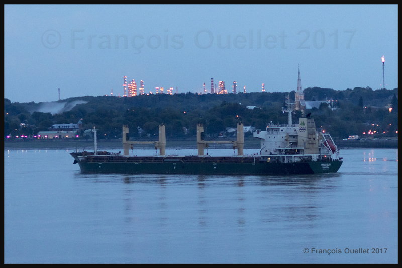
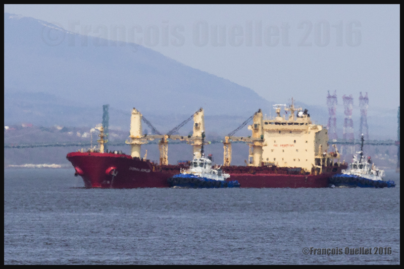
The Harlequin in front of the Jean Gaulin refinery in Lévis, 2017.
The picture above shows the Harlequin, a bulk carrier built in 2012 that has a 9.7 meter draught. It sails under the Cyprus convenience flag. On June 18th 2017, when the photo was taken, it was in front of the Jean Gaulin refinery in Lévis, Quebec, and was about to cross the Atlantic heading to Rouen, France. The Jean Gaulin refinery is Quebec’s largest refinery and ranks second in Canada when it comes to refining crude oil.
The photo was taken at 21:07, just before nightime. Since I was positioned on the highest floor of the Quai des Cageux wooden tower, there were constant vibrations associated with people going up and down the stairs. The tower’s movement combined with a moving vessel made the use of of tripod totally useless. It was thus necessary to make a handheld photo, which seriously increased the risk of a blurred picture considering the lack of light.
A Canon EF 85mm f/1.2 II USM fixed lens installed on a Canon 5DSR full frame camera helped to make a successful shot. The fact that this kind of lens requires very little light increases the photographer’s margin of manoeuver. It would obviously have been possible to increase the ISO to 6000 and more to compensate for the poor lighting, but that would have degraded the photo’s quality. The ISO was thus limited to 2000, with a shutter speed of 1/200 sec and a 1.6 aperture.
In order to limit the risk of a blurred picture, it was necessary to follow the movement of the ship with the camera. The closer one gets to immobilizing the ship in the viewfinder, the better the chances of a defined photo.
Since the ship was farther than it appears on the picture above, some cropping was mandatory to bring the vessel to a decent size. If the ISO had been too elevated to start with, the ensuing photographic grain would have been too big after the cropping and the quality of the picture would have suffered. With an ISO limited to 2000, the image kept a decent definition.
For other pictures of ships on my website, click on the following link : Ship photography.
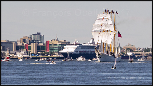
The chilean vessel Esmeralda and its crew during the Tall Ships Regatta 2017 in Quebec City.
In July 2017, the four masted Chilean sailboat Esmeralda arrived in Quebec City for the Tall Ships Regatta 2017. The arrival was quite spectacular, as the whole crew sang together for several minutes for the people standing along the pier.
In order to avoid any distraction, the full frame picture has been taken in the portrait mode and the cropping was tight enough to bring forward the crew members standing up high away on the masts.
The picture below offers another point of view of the sailboat masts but this time the importance is given to the colored chairs directly installed in water, allowing the tourists to cool down during a particularly hot summer day. The wide angle lens used for the shot was a Canon 14mm f/2.8L. Two diagonal lines created by the pool in the foreground progressively meet with each other in the distance, in front of the sailboat.
The vessel Esmeralda during the Tall Ships Regatta 2017 in Quebec City.
When the Tall Ships Regatta 2017 ended, several small boats approached the Esmeralda and other sailboats to slowly travel with them from Quebec City until they cleared île d’Orléans. In the picture below, you can see the cruise ship Maasdam, which has been repositioned to a new pier in the Port of Quebec in order to accomodate the sailboats.
The ship Maasdam and the vessel Esmeralda during the Tall Ships Regatta 2017 in Quebec City.
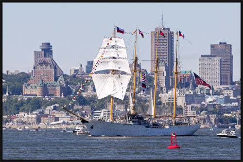
In the picture below, the sailboat Esmeralda his heading towards the north of île d’Orléans as the final parade is completed. On the left, you can see the Château Frontenac and, directly behind, the Hotel Le Concorde Québec, with in its upper ring a revolving restaurant offering a superb view of Quebec City. The hand held photo was taken from île d’Orléans with a Canon EF 70-200mm f/2.8L IS II USM telephoto lens. This lens is equipped with an integrated stabilizer.
It would nonetheless have been quite difficult to succeed with such an important cropping without the performance of the 50.6 megapixel full frame sensor used in the Canon 5DSR. Considering the great distance over water that is present between the camera and the sailboat, it is possible that you notice a mirage effect, even with the small picture presented here.
The vessel Esmeralda in Quebec City during the Tall Ships Regatta 2017. In the background, the Château Frontenac and the hotel Le Concorde.
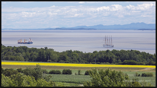
I thought the crew would use all of the sailboat’s sails once passed île d’Orléans, but it was not the case. The picture below was taken from the top of a wooden tower installed at the north east extremity of île d’Orléans, while the Esmeralda is still navigating using its engine.
Even without the sails, the photographic composition benefited from a yellow field, a merchant ship and a lively horizon line showing the Appalachian mountains. No tripods were used for the shot as the wooden tower was constantly moving. The telephoto lens used was a Canon EF 70-200mm f/2.8L IS II USM and a slight cropping was necessary.
An approximative rule of thirds is behind the composition of the photo : you can imagine three fictive horizontal lines dividing the frame. The sailboat also finds itself on one of the rule of thirds vertical line on the right.
The vessel Esmeralda, from Chile, sailing on the St. Lawrence Seaway after its departure from the Tall Ships Regatta 2017 in Quebec.
For other pictures of ships on my blog, click on the following link : Ship photography.
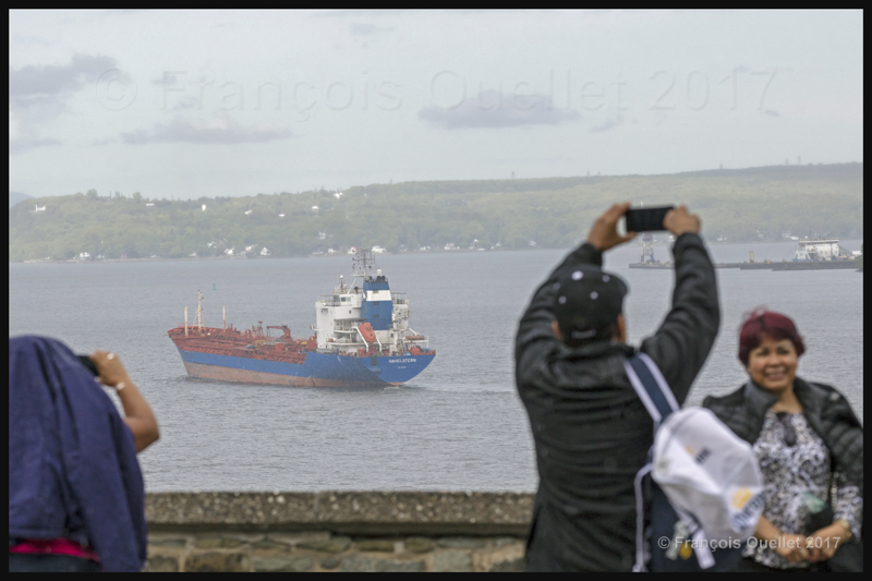
The Havelstern is a chemical tanker sailing under Canadian flag which was built in 1994. Its draught is of 8.5 meters. It is photographed here on June 3rd 2017 in front of Quebec City, with Lévis in the background, heading to Point Tupper in Nova Scotia, Canada.
The Havelstern between Quebec City and Lévis on June 3rd 2017
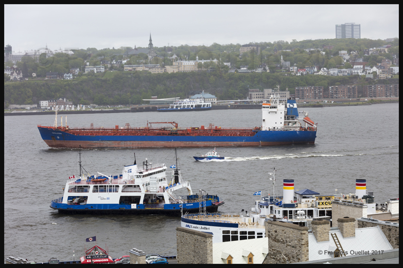
Several vessels are visible in the picture above. In the foreground, it is possible to see the two chimneys of the Louis Joliet, a boat essentially used for tourist excursions. Then there is one of the two ferries constantly traveling between the south and north shore of St. Lawrence Seaway between Lévis and Quebec City.
The small boat riding by the Havelstern is used to carry one of the St. Lawrence Seaway pilots. A pilot who masters the navigation specifications on this part of the seaway boards the ship and takes control until he can transfer the control to another pilot farther down the seaway ( Pilotes du St-Laurent ). In the background is the second ferry used to carry passengers and cars from one shore to the other.
The full-frame camera used to take the pictures was a Canon 5DSR equipped with a Canon EF 70-200mm f/2.8L IS II USM lens. With a 5.0 aperture and the ISO set at 200, the shutter speed allowed was 1/1000 sec.
The Havelstern ship and île d’Orléans in the background, June 2017
While the tourists are having fun in Quebec City, the picture above shows the Havelstern heading to Île d’Orléans in a rain shower.
The picture below represents the Havelstern making a wide turn to navigate around the southern portion of Île d’Orléans. The ship was quite far away and some serious cropping would have to be done in order to enlarge the image. In order to get a picture that would not be blurred, I had to increase the shutter speed a bit.
The Havelstern ship is approaching Île d’Orléans in June 2017, heading to Point Tupper in Nova-Scotia
The ISO was adjusted to 200 and the focal length was set to 200mm. The aperture was only 4.0, allowing a shutter speed of 1/2500 sec.
For other pictures of ships on my website, click on the following link : Ship photography.
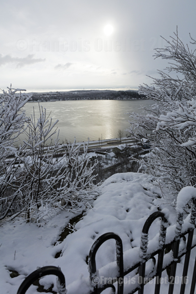
Quebec City in winter, in the Cap-au-Diable area (2016)
The picture above was taken in December 2016 at Cap-au-Diable, in Quebec City, with a Canon 5DSR full-frame camera equipped with a Canon EF 24-70mm f/2.8L US telephoto lens. A polarizing filter was not really needed here due to the soft light and the sun being in line with the lens. The exposure was still corrected by +1/3.
At this time of the year, the temperature is not too cold for the photographer’s bare hands and the light intensity is ideal throughout the day. The temperature hovering around 0 °C favors wet snow showers. This snow lightly sticks to the tree branches and, as long as the wind does not increase too much, it is possible to take interesting winter pictures. But it is necessary to act quickly
For the photo above, I was able to profit from a St-Lawrence Seaway that was still unfrozen, which allowed to capture the winter sun reflection. I had to proceed rapidly since there were clouds moving from the west, visible to the right of the picture. One minute later, the sun and its reflection were no longer visible.
The photos below were taken during in the same park.
Parc du Cap-au-Diable, Quebec City (2016)
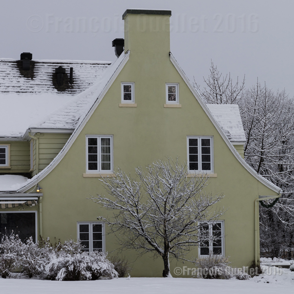
A house in the Cap-au-Diable park, Quebec City (2016)
For other photos on the province of Quebec and also Quebec City, click on the following links from my blog:
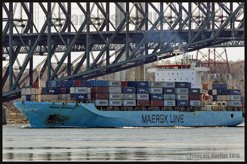
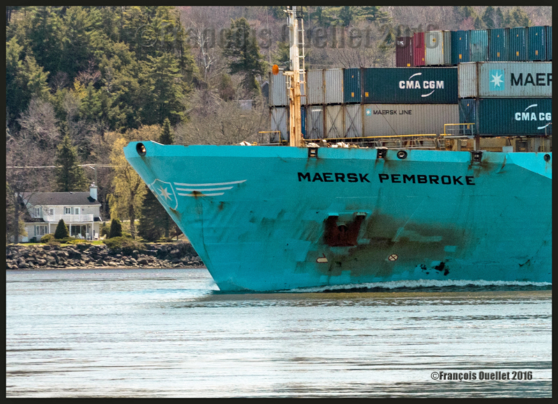
The container ship Maersk Pembroke under the Quebec Bridge, May 2016
Choosing what is important in a camera
Since there is actually no camera that has everything, whatever the brand, the buyer of a new camera must make choices: the type of sensor, the number of megapixels, the weight and size of the camera, the automatic focus’s speed and ability to follow a subject, the number of images per second, the performance under low light, the possibility to greatly enlarge a picture while maintaining its quality, advanced video functions, electronic communications with other devices, an extensive choice of lenses, etc. The list can be quite long…
The Canon 5DS(R): a specialized camera
A photographer happy with the Canon 5DS or 5DSR is one who needs a specialized camera offering both sharp images and the possibility of greatly enlarging the pictures it takes while maintaining the initial quality. This camera allows for more creativity as the possibility of extreme cropping beats, for now, everything that is on the market in the DSLR format.
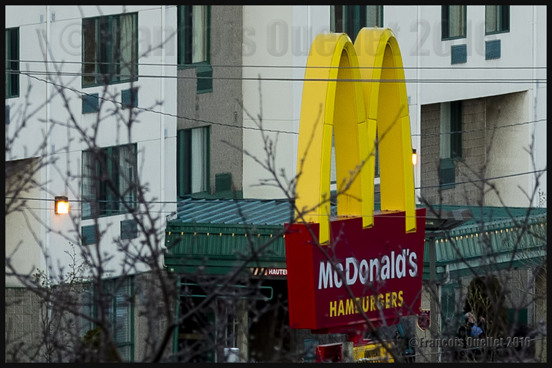
Testing the potential of the Canon 5DSR when it comes to enlarging a picture
Here is an example of what this means: the photo below shows the yellow M of the McDonald’s restaurant photographed with a 50mm lens. Not easily visible…
Mc Donald’s restaurant’s yellow M captured with a 50 mm lens. Hard to see, of course!
Then the next photo was taken with a Canon EF 70-200mm f/2.8L IS II USM telephoto lens set at a 200mm focal length.
Testing the Canon 5DSR: the Mc Donald’s restaurant’s yellow M enlarged through a Canon EF 70-200mm f/2.8L IS II USM telephoto lens. Focal length used: 200mm.
But the picture can be enlarged a lot more using the amazing resolution of the Canon 5DSR. The following picture shows the result after cropping the 200mm image: the yellow M now takes the whole vertical space available in the picture without any loss in quality.
The Mc Donald’s restaurant’s yellow M, after having been enlarged (focal 200mm) and cropped within the Canon 5DSR.
From my position on the hill, the yellow M was barely visible with the naked eye. By using a 200mm focal length, followed by serious cropping, I was able to obtain the result above. So it is possible to photograph a subject that is almost invisible without a telephoto lens and transform it into the principal subject of the picture without any loss in quality.
I chose the 5DSR because the anti-aliasing filter has been neutralized in the model R to offer even sharper images, although there is a risk of occasional moire effect when there are repetitive patterns in a scene. This is the compromise that Nikon users must also have to deal with.
Rethinking photography
The 50.6 megapixel full frame sensor in the Canon 5DS or 5DSR allows a new approach of photography for those who do not have access to a much more expensive and larger medium format camera that does not necessarily give really superior pictures.
When I go outside for a photo session, it seems to me that I now carry a huge telephoto lens without the weight and the cost. A lot of what seemed to be unavailable possibilities are now accessible.
Taking pictures of people in the street is now less complicated: there are no more suspicious looks, artificial poses or people hiding their face. This is an ideal camera to capture people acting naturally without disrupting their routine. Gone is the feeling that you are bothering them in any way.
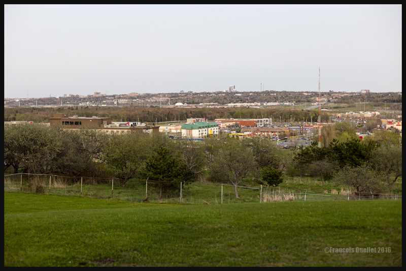
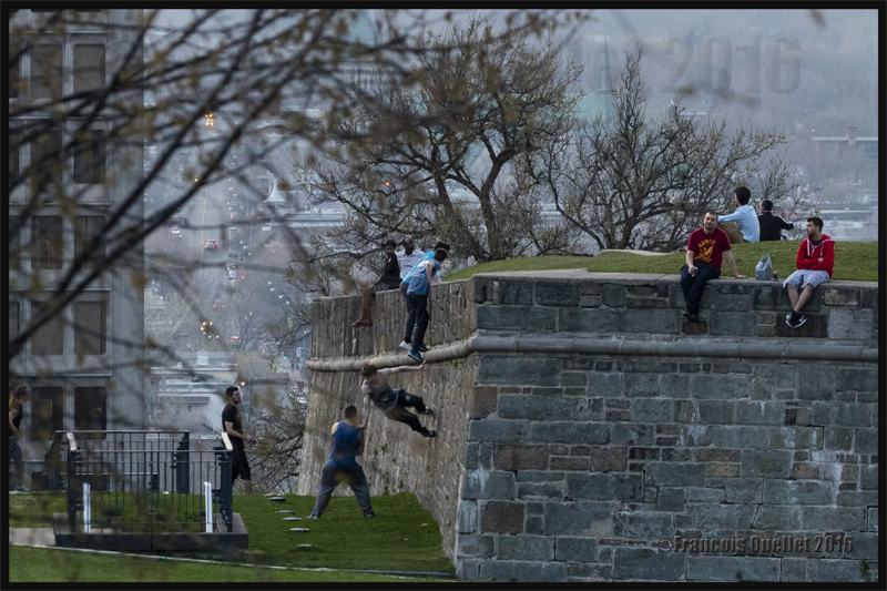
Quartier Petit-Champlain Old Quebec May 2016
The photo below was taken while I was standing at least 300 meters from the scene, just after sunset. For those who are from Quebec City, I positioned the tripod on a high wall on the other side of Chemin St-Louis, near the St. Louis Gate. I had to slightly brighten up the picture to make the details more visible, risking at the same time to increase the digital noise. It was a May 2016 warm misty evening, which is clearly visible by the lack of details in the background as we look in the distance.
Quebecers defying gravity in Old Quebec, May 2016
But those are not the only possibilities of this camera. The Canon Company, in its promotional video, explains what exactly the camera was designed for:
How can someone maximize the use of a 50.6 megapixel full frame sensor
In order to bring a subject closer to you while fully benefiting from the Canon 5DSR 50.6 megapixel full frame sensor, it is obvious that there must be absolutely no vibrations. The photographer must therefore use a tripod, a remote control release and the mirror lock-up function. This allows for a very low ISO setting while avoiding a blurred picture.
The mirror lock-up function is very well thought through, with the possibility to choose a totally automatic processus according to a timing chosen by the photographer (between 0 and 2 seconds). The system eliminates any secondary micro vibrations.
In order to ensure an even better picture, the photographer must use Liveview and set it to the 16X enlargement available on that camera (versus 10X on my Canon 5D MKII) to manually adjust the focus. It is then possible to see the slightest vibrations caused by the wind. Doing so, I realized that my camera strap, lightly swaying in the wind, was causing some minimal vibrations. Every detail taken into consideration will improve the final result.
One must then ensure to immobilize the strap and even diminish the tripod height if possible when the wind is blowing. These steps will allow an incredible enlargement of a subject while maintaining the initial quality of the image offered by a full frame sensor.
Superior mirage effect (cold mirage)
The photo below shows a ship being helped by two Ocean tugboats on its way towards the Quebec Harbour. The ship was at a good distance from the harbour; it is then possible to witness the superior mirage effect (cold mirage) resulting from a temperature inversion immediately over the water. The boats are deformed but the important close-up has not lowered the image quality. It has instead allowed to increase the atmospheric phenomenon effect.
Superior mirage (cold mirage) effect. Vessel and two Ocean tugboats on the St-Lawrence seaway heading to the Quebec Harbour, May 2016.
Once closer to the Quebec Harbour, the cold mirage effect decreased, as shown on the picture below:
Quebec Harbour, May 2016
The Canon 5DS or 5DSR without the use of a tripod or mirror-lock
Obviously, a tripod is not necessary if you do not intend to use a lot of cropping to enlarge a photo. You will obtain excellent results with the hand-held camera providing that you remember that this Canon DSLR is a specialized tool.
So many megapixels on a sensor of that size require that the photographer adapts his technique. But, as you can see from the picture below, it is totally possible to capture an aircraft in movement, even at dusk (May 11, 19:49), when the camera’s parameters are correctly adjusted. A higher shutter speed than normal is, in this case, absolutely mandatory.
The photo below shows an Air Canada Express Bombardier DHC-8-402NG (C-GSJZ) on final for runway 29 at the Quebec Jean-Lesage international airport (CYQB).
Bombardier DHC-8-Q-402NG (C-GSJZ — Air Canada Express) on final for the Quebec Jean-Lesage international airport, May 2016. Photo taken with a DSLR Canon 5DSR.
The Maersk Pembroke with the camera hand-held
The photo below shows the Maersk Pembroke container ship photographed with a hand-held camera using a Canon EF 70-200mm f/2.8L IS II USM telephoto lens during Spring 2016 near Quebec City. The focal length was only 140mm and the shutter speed 1/1000. The lens was equipped with a polarizing filter and the photo taken when the vessel was approaching the Quai des Cageux.
The Maersk Pembroke container ship on the St-Lawrence seaway near Quebec City, May 2016
The colours produced by the Canon 5DSR
The digital processing of the image and colours produced by the Canon 5DSR require different adjustments than what was necessary with the Canon 5D MKII. I am still learning how to handle the results produced by this camera so I will wait a bit before commenting.
View of Old Quebec from the St. Louis gate. Quebec City, May 2016
Night photography
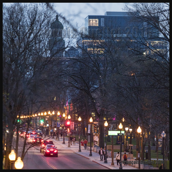
Here are two photos taken during the evening in Quebec City. The photo below required a 200mm focal, an ISO set at 4000 and a shutter speed at 1/30 in order to obtain something else than trailing lights. Luckily, the traffic was moving slowly…
Night photography, Grande-Allée avenue, Quebec City, May 2016
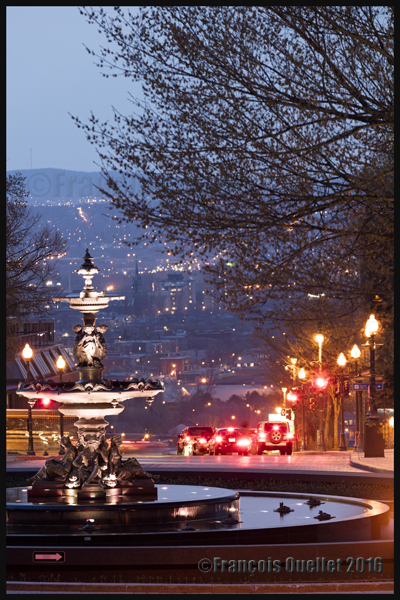
The picture below, taken with a 200 mm focal, required an exposure time a bit longer that one second with the ISO set at 800. To take the photo, I took advantage of the fact that the cars were momentarily stopped at a red light, so that they would be clearly visible.
Night photography, Tourny fountain and Quebec lower town, May 2016
The images per second of the Canon 5DS(R)
The Canon 5DSR is so far quite an impressive camera. I would have appreciated that Canon offer a higher rate of images per second (7 instead of 5) to make it more versatile.
The camera allows taking pictures with smaller formats than 50.6 MP, the two other options being 28 MP and 12 MP. If the camera can deliver five images per second with 50.6 MP RAW files, we can deduct that it is able to offer more speed for smaller formats. But the camera is blocked at 5 IMS so that it, I suppose, does not compete with other existing Canon models of the same category…
Nonetheless, Canon says that the rapid sequence of shooting lasts longer if the photographer uses the smaller files provided. So it is not faster, but it keeps on firing for a longer period. My guess is that it would only require a new firmware version to improve this camera’s number of images per second.
For other night pictures, click on the following link to my site:
(Precedent story: carrying a .357 Magnum to Iqaluit)
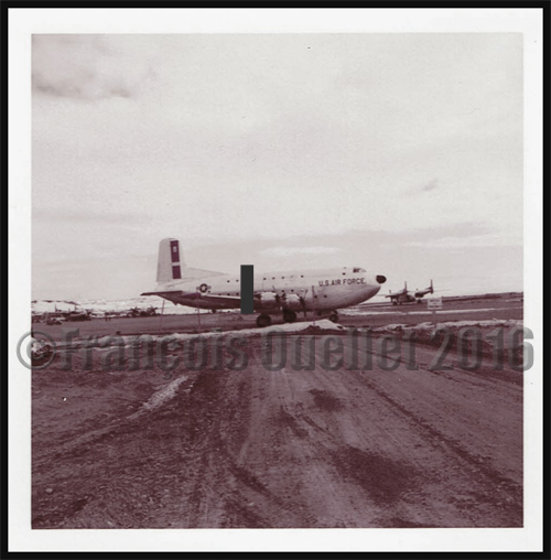
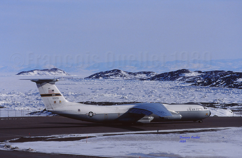
An American Trans Air Lockheed L-1011being refueled in Iqaluit, Canada, in 1989. I had the opportunity to leave the flight service station (the yellow tower) for few minutes to take this picture.
Before retelling some of the events that happened while I was working at the Transport Canada flight service station in Iqaluit, in the Nunavut (1989-1991), it is mandatory to present few important dates that will allow the reader to understand why the airport was initially an American military base.
1938. Hitler’s ambitions are such that Roosevelt deemed necessary to announce the following: “I give you assurance that the people of the United States will not stand idly by if domination of Canadian soil is threatened by any other empire ».
1939. Beginning of discussions between Canada and United States with regards to joint defense of the North American continent.
1940. Great-Britain was at risk of losing the war against a Germany that was progressing rapidly in its conquest of the European soil. When Denmark was defeated in autumn 1940, fear grew that the Germans would progress westward and establish operational military bases on the newly acquired territories.
Greenland belonging to a defeated Denmark, Germans would be using it to get closer to Canada. At the time, Greenland was the sole commercial source of cryolite, an essential component of aluminum used in aircraft production.
There was also a province which was not part of Canada in 1940 and which presented a strategic interest for an enemy in its war against Canada and United States: Newfoundland and Labrador.
In order for the war not to be fought directly on the North American territory, one had to keep the Germans busy in Europe. It therefore meant that Great-Britain must not be defeated.
1941. Ships carrying short range fighting aircrafts from America to Europe were regularly attacked and sunk by U-boats. It was imperative to change the route. Canadians and Americans were looking for the best sites that could accommodate the construction of runways allowing short range military aircrafts to fly up to Prestwick, Scotland.
This new route was called “Crimson Route” and the stopovers were Goose Bay in Labrador, Fort Chimo (Kuujjuaq) in Quebec, Frobisher Bay (Iqaluit), on Baffin Island in the Nunavut as well as three sites in Greenland (Narsarsuaq, Angmagssalik and Sondre Stromfjord (Kangerlussuaq). The Frobisher Bay coded name became “Crystal Two” base.
1941-42. Germans established the first inhabited weather bases on the Greenland coast in order to facilitate U-Boats operations across the North Atlantic. When those sites were discovered, they were destroyed by American commandos.
1942. U-Boats entered the St-Lawrence seaway and sank Canadian ships.
1942. The site initially chosen to establish the Frobisher Bay airport (the Crystal Two base) was Cromwell Island, located 20 miles south-west of today’s actual site for Iqaluit. This was until a new site was discovered (today’s site) that favored the construction of longer runways and allowed the beaching of flatboats loaded with cargo during the summer period.
A McAllister flat-bottomed barge will soon be unloaded in Iqaluit, during low tide.
A ships convoy carrying thousands of tons of cargo planned for the construction of the Frobisher Bay base arrived at destination. This convoy was nonetheless attacked by the U-517 U-Boat and the cargo-ship Chatham, carrying 6000 tons of material destined for Crystal One and Crystal Two bases was sank.
1943. An German automated weather station was built at Martin Bay, in Labrador, to facilitate the U-Boats operations. This weather station is now in permanent exhibition at the war museum in Ottawa. Pictures have been found were we can see smiling but armed German soldiers taking the pose near the automated weather station. Canada accidently learned about the existence of that weather station in 1980.
German automated weather station in exibit at the War Museum in Ottawa
Many German officers and soldiers who were captured in Europe were sent abroad while waiting for the end of the war. My grandparents, who owned a farm in St-Ignace, Quebec, became responsible, over time, for one German officer and two soldiers. They had only good comments on the behavior and desire of the prisoners to help on the farm.
1943. Both Frobisher Bay runways were now operational, although without being totally completed. The engineers did not have the knowledge of the Russians when it came to maintaining airport runways in the Arctic. Damages caused by permafrost were significant and the runways necessitated a lot of maintenance. The water present under the runways would sometimes surface suddenly and create five meter deep holes. Those runways needed a constant effort to remain usable.
The first runway to be built was eventually abandoned due to a wrong evaluation of the prevailing winds and the dangers associated with the surrounding elevated terrain. Today only remains the runway that we know in Iqaluit, although extended to 9000 feet. The year 1943 recorded 323 aircraft arrivals, of which only a small number made the complete trip to Europe.
1944. War took a new turn. The newly developed long range radars, allied to advanced technology in the detection and attack of submarines, radically diminished the U-Boats threat in North Atlantic. The “Crimson Route” airports were suddenly losing their pertinence. The Canadian government, worried about the massive presence of Americans in the Canadian Arctic, bought the airports from the American government.
1950. Canadians officially took control of the Frobisher Bay airport, but authorized an American presence since this airport had a new strategic importance in the cold war that followed Second World War. The weather station and runway maintenance were taken care of by American forces.
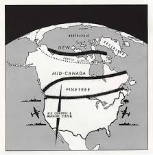
1951-53. A radar station was built on a hill northeast of runway 17-35. This station completed what was then known as the Pinetree line. This line was made of several long range surveillance radar stations; it covered all of southern Canada and gradually curved towards the north to end up in Frobisher Bay. All those stations were inhabited and could order interceptions at all times against potential enemy forces, by means of jet aircrafts.
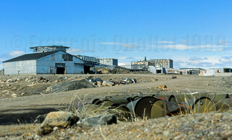
What is left of the old American military base in Frobisher Bay (Iqaluit), Canada. I took the picture in 1989.
1955. Americans received the authorization from Canada to build a SAC [Strategic Air Command] military base where numerous KC-97 tankers were stationed in support of B-47 bombers operations carrying nuclear armament. The base was built in 1958 and, until the end of its operations in 1963, parking space was occupied by at least seven KC-97. The SAC base was not needed anymore after the new Boeing B-52 bombers and KC-135 tankers were developed.
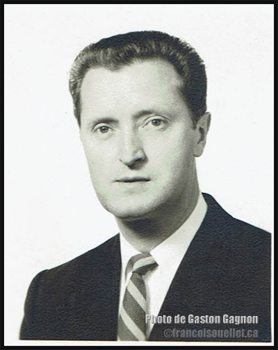
A French-Canadian military from Quebec at work in Frobisher Bay
Gaston Gagnon during the period where he served as a Canadian military in the communication field, at the Frobisher Bay station of the Pinetree Line in Canada in 1955. He died in 2016.
My uncle Gaston Gagnon was part of the French-Canadian military staff who was in service in Frobisher Bay. He volunteered for service during the Second World War (1939-1945).
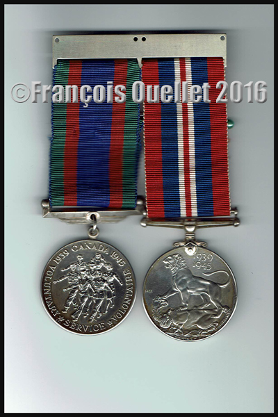
War medals (volontary service and honorable service during the Second World War (1939-1945) belonging to the French Canadian Gaston Gagnon who died in 2016
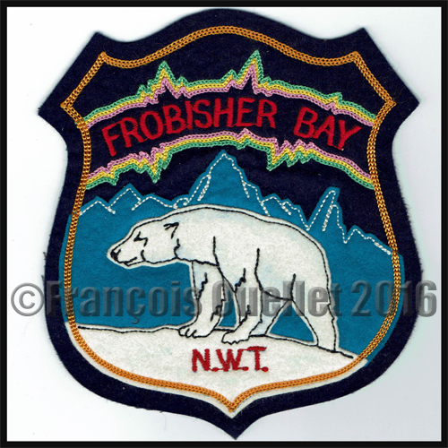
Frobisher Bay, N.W.T., Canada crest
He worked in the communication field during the Cold War and, after he died in 2016, I received some pictures that were taken in 1955 in Frobisher Bay. Those photos also witness of the American presence in Frobisher Bay.
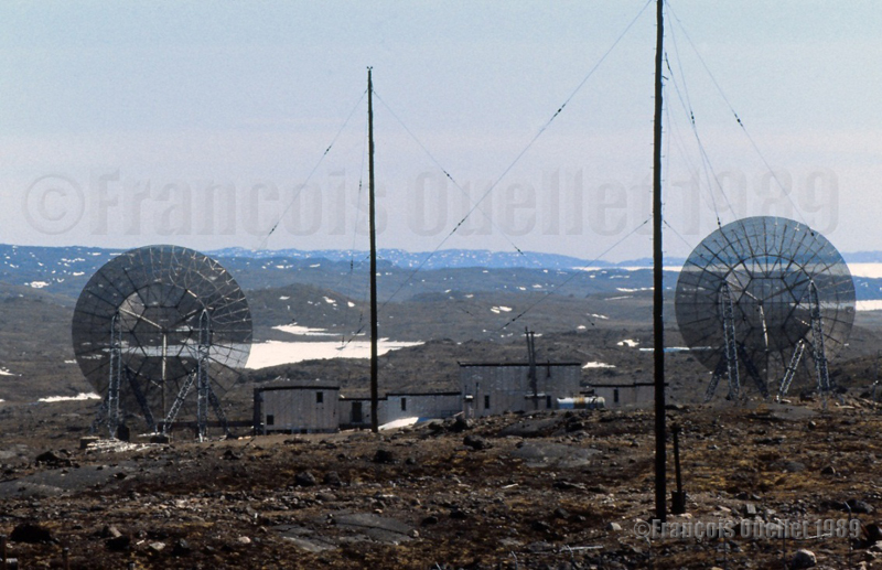
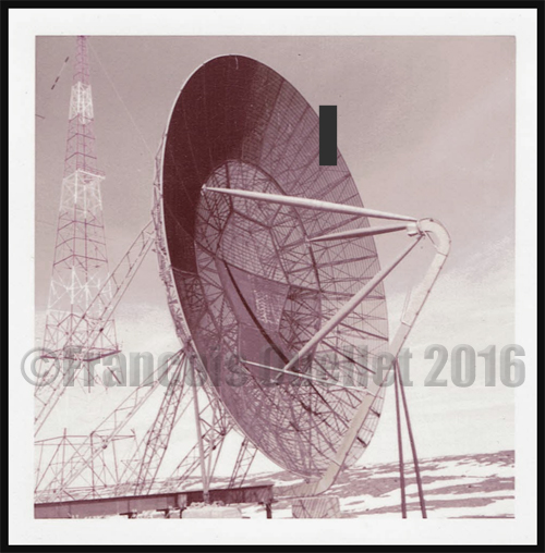
Radar dish at the Frobisher Bay, NWT, Canada Pinetree Line Station in 1955
American soldier posted at the Frobisher Bay NWT Canada Pinetree Line site in 1955
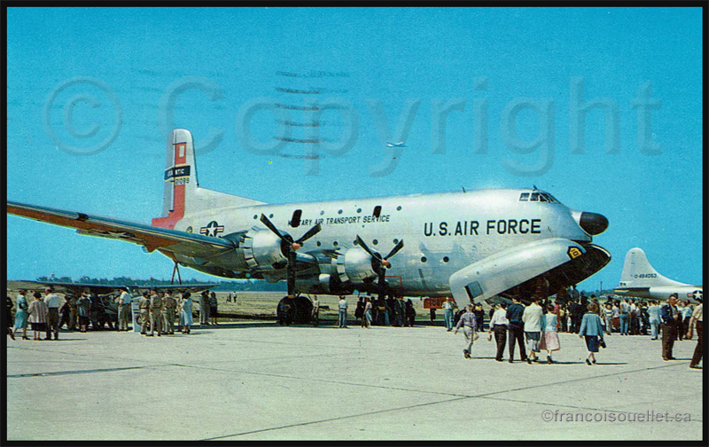
Globe Master C-124 aircraft of the Military Transport Air Service (U.S. Air Force) in Frobisher Bay, NWT, Canada in 1955 serving the Pinetree Line stations during the Cold War.
C-124 Globemaster. Military Air Transport Service in United States (around 1957)
Frobisher Bay, N.W.T., Canada crest
1960. The runway was extended from 6000 to 9000 feet.
1961. The Frobisher Bay radar station, part of the Pinetree line, was closed but the Polevault station remained in activity.
DEW and Pinetree lines over Northern Canada
1963. Americans left Frobisher Bay and gave control of the Polevault station to the DOT [Department of Transport], an older designation of Transport Canada.
Old American military base in Frobisher Bay (Iqaluit)
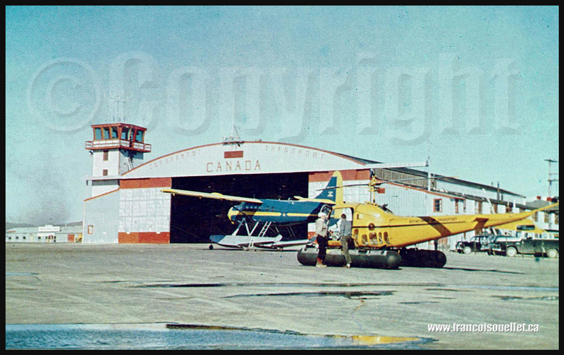
1964. The radio operator, and later flight service specialist (FSS) Georges McDougall, arrived in Frobisher Bay. All the village inhabitants eventually got to know Georges since he provided air traffic services there for at least thirty-seven years, seven days a week, on shifts work. He progressively became a privileged witness of all the unusual events to happen in the village and at the airport.
Below is a picture of the old DOT hangar and tower.
People and DOT Canada in Frobisher Bay NWT aviation postcard
1987. Frobisher Bay was renamed Iqaluit.
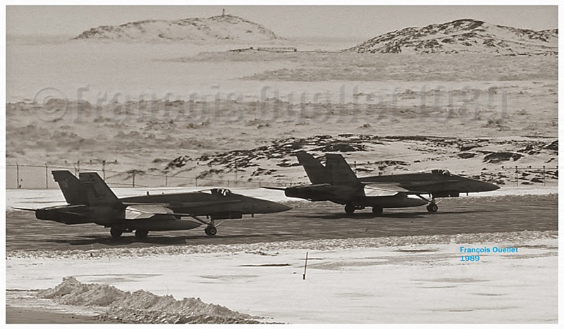
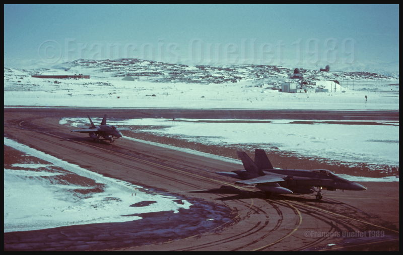
Two Canadian CF-18s holding short of runway in Iqaluit (1989)
1989. Stacey Campbell wrote an article in News North that she titled: “Military Jets Fill the Arctic Skies”. She explained that NORAD (North American Air Defence) regularly held exercises aimed at testing the capacity of Canada’s new radar defense system to detect potential enemies approaching from the north.
The interviewed military officer told Stacey that CF-18 fighter jets, tankers and B-52 bombers, among other types, would be part of the operation. The CF-18’s would temporarily be stationed in Iqaluit, on Baffin Island, and Inuvik for the duration of the exercise. Other types of aircrafts were also involved in that annual test, like the F-15, T-33 and possibly the AWAC although the latter did not land in Iqaluit.
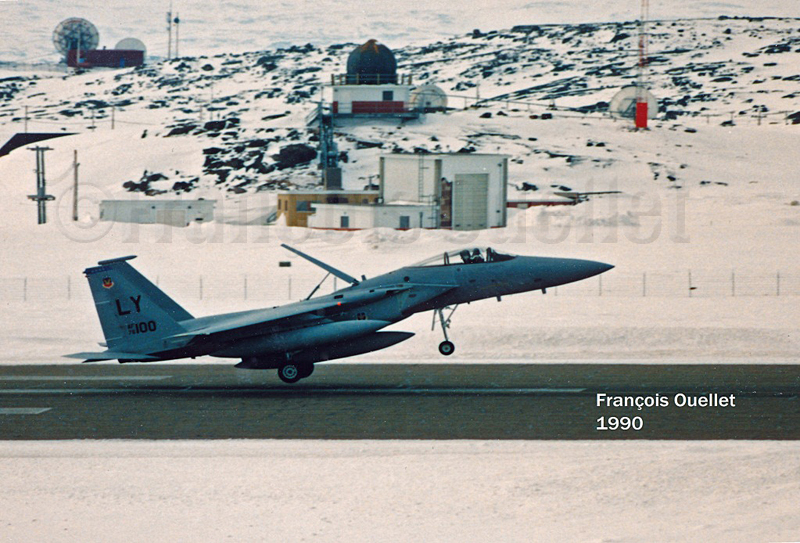
American F-15 landing in Iqaluit
The local Transport Canada flight service specialists (FSS) had to deal with the tight operating schedule provided by a military officer as well as integrate the daily arrivals and departures of private and commercial aircrafts.
At the time, the most useful taxiway, one which was located near the end of runway 35, could not be used since the terrain was too soft. All the aircrafts using runway 35 were forced to backtrack that runway before it could be cleared for other incoming or departing aircrafts. The additional time required for that procedure sometimes gave headaches to the military officer sitting by our side.
American F-15 Eagle airborne from Iqaluit
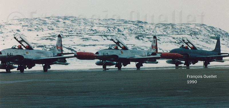
Canadian T-33s in Iqaluit (1990)
American Starlifter cargo aircraft ready for take-off in Iqaluit (1989)
I remember that the military officer in charge of the mission told us: “If the jets cannot takeoff within the next minute, the mission will be aborted”. It just happened that during the tight window within which the CF-18’s had to be airborne that day, there were many commercial aircrafts like the Avro 748, Twin Otter, Boeing 727 and 737 and other executive aircrafts operating around Iqaluit. There was always a way to please everybody and the military exercise ended the way it was initially planned.
Two Canadian CF-18s in Iqaluit (1989)
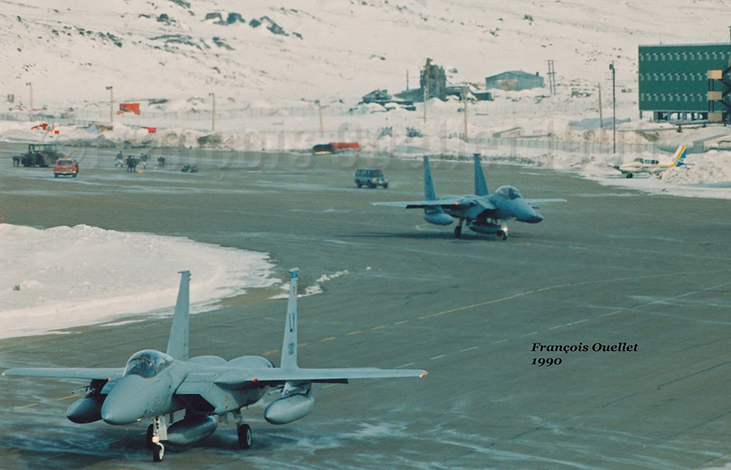
Two American F-15 Eagle taxiing for departure in Iqaluit (1990)
This was a period much appreciated by the flight service specialists (FSS) since, for one week during the year, our operations changed radically: we had to respect the imperative needs related to the military exercise as well as continue to provide regular air traffic services.
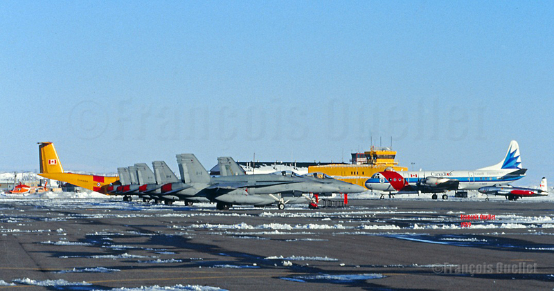
Six Canadian CF-18s, one Lockheed Electra Ice Patrol aircraft, a Dash-7 and a T-33 in Iqaluit
It was brought to our attention, for having discussed with many pilots involved in the exercise that military forces were kind enough to offer, through our Transport Canada manager, few posters signed by pilots of squadrons involved in the “Amalgam Chief” exercise. Although the manager never deemed necessary to show his staff even one of those posters, I appreciated the gesture from the pilots.
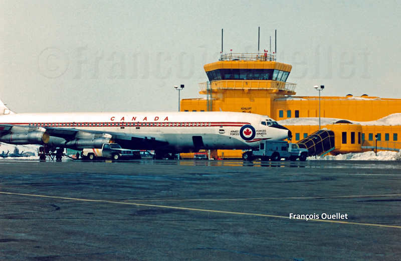
Canadian Armed Forces Boeing B-707 in Iqaluit, in front of the flight service station tower
1993. In order to replace a DEW line that had become obsolete, Canadians and Americans jointly built a new base that would now be used for logistical support for the new North Warning System.
Two Canadian fighter aircrafts CF-18 leaving the runway in Iqaluit.
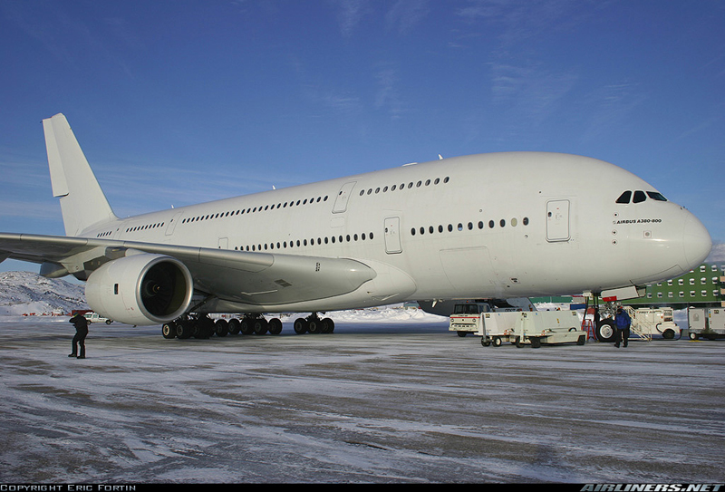
2006. Extreme cold tests were held in Iqaluit by Airbus for the A-380, the biggest passenger aircraft in the world.
Airbus A380-841 in Iqaluit, Canada, during cold weather testing
2014. Extreme cold tests were held by Airbus for its new A-350 XWB.
2015. Canada was the host of the Arctic Council Ministerial Meeting in Iqaluit. The Council is composed of the following countries: Canada, Sweden, Denmark, Finland, Iceland, Norway, Russia and United States. Joining the meeting were senior representatives of indigenous organisations holding the status of permanent participants.
Dassault completes several cold-soak trials in Iqaluit for its Falcon 6X
Pope Francis visits Iqaluit during his Canadian trip aimed at healing and reconciliation with Indigenous groups and residential school survivors.
2024. An Air France Boeing 797-900 makes an emergency landing in Iqaluit due to a burning smell reported by passengers.
(Next story: The military exercise “Amalgam Chief”: B-52 bombers in northern Canada)
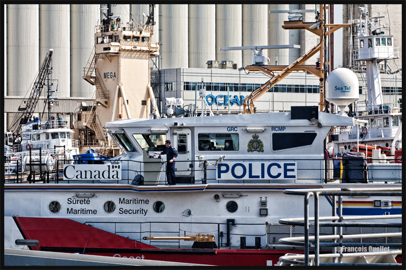
In order to give an impression of a very busy day in the Port of Quebec, during Spring 2015, I used a Canon 70-200 f2.8L IS II USM. A zoom is very useful to achieve some special effect in photography.
The apparent chaos in the photo is created by numerous details: first of all, the viewer has to read numerous words that have very different impacts on him: POLICE, CANADA, OCEAN, Sécurité Maritime, Maritime Security, GRC, RCMP, MEGA, Sea Tel, and part of the word Coast.
Secondly, there are numerous vertical lines of all sizes that interfere with multiple horizontal lines. The BUNGE silos, in the background, are themselves vertical lines, but much larger than the others.
The compressed perspective obtained through the use of a zoom gives the viewer a feeling that all the objects are close to each other. We are left wondering how the captain can manoeuver his boat with such little space available.
What is really happening in the scene: it is a very quiet day, where almost everything is immobile. There is only one boat that has started to move and the captain has all the space needed to leave the Bassin Louise and head toward the St-Lawrence Seaway without being concerned with any serious obstacle.
For other boat or ship photos posted on my website, click on the following link:
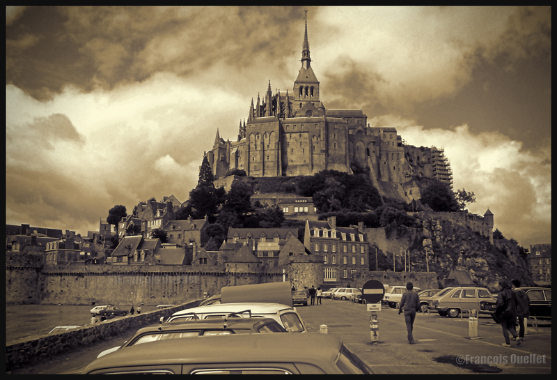
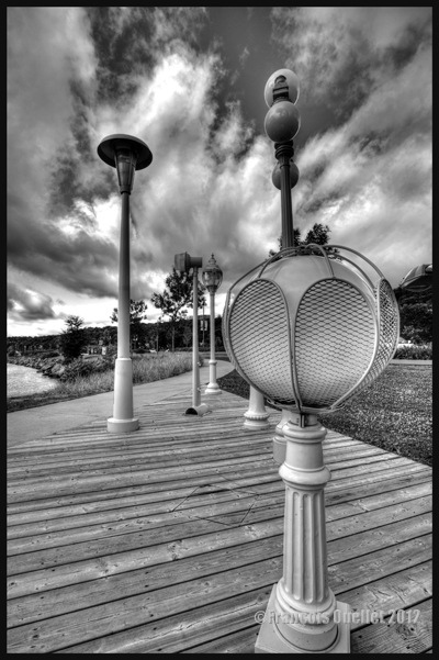
Cumuliform clouds add energy to any photo. Even photos in black and white benefit from them largely, whether it is for a normal or an HDR photo.
Cumuliform clouds add dynamism to this Abbaye du Mont St-Michel scenery. France (1978)
Black and white HDR picture of lamp posts installed along the St-Lawrence, Quebec City 2012.
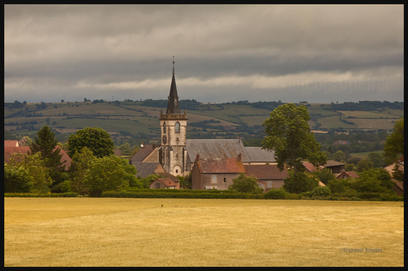
The stratiform clouds add to the tranquillity and the stability of a photo.
Daytona Beach under stratus clouds in 2011. The end of the afternoon allows the fresh air from the sea to move over the heated land, which helps create few cumulus fractus, visible near the buildings.
Clouds including a stratiform and cumuliform components (stratocumulus) produce an effect that is more energizing than the simple stratus, while avoiding the explosion of energy of the cumuliform clouds.
A stratocumulus adds to this otherwise peaceful scenery captured on board the Lyria train between Paris and Geneva in 2013.
The cold front
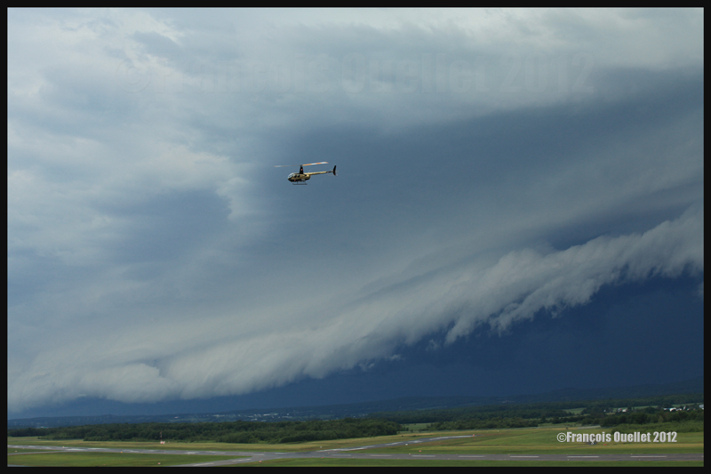
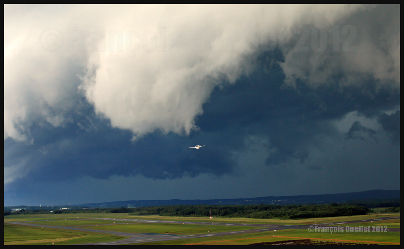
The approach of a cold front enhances the possibility of interesting photos. If it is a fast moving cold front of moist and unstable air, the photos will probably be more spectacular, as some thunderstorms will be associated with the system. A dew point of more than 15 C indicates the presence of a lot of water vapor which can be transformed into precipitation, thus releasing a lot of energy. When these conditions are combined with a really strong contrast between the new air mass which approaches and the one which goes away, the produced meteorological phenomena will certainly be intense.
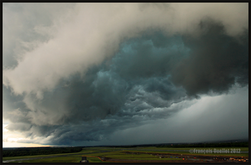
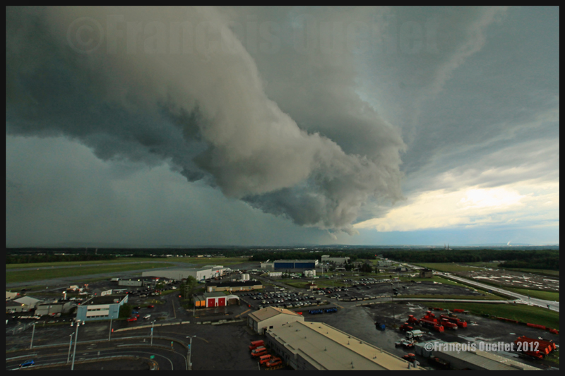
In the photos below, the meteorological system approaching the Quebec Jean-Lesage international airport also had to cross a small mountain range.
A roll arcus cloud in development ahead of a thunderstorm approaching the Quebec Jean-Lesage airport in 2012.
A roll arcus cloud in development ahead of a thunderstorm approaching the Quebec Jean-Lesage airport in 2012.
View under a developing arcus cloud at the Quebec Jean-Lesage international airport (2012)
An arcus cloud ahead of a thunderstorm approaching the Quebec Jean-Lesage airport in 2012
A roll arcus cloud ahead of a thunderstorm heading for Quebec City in 2012
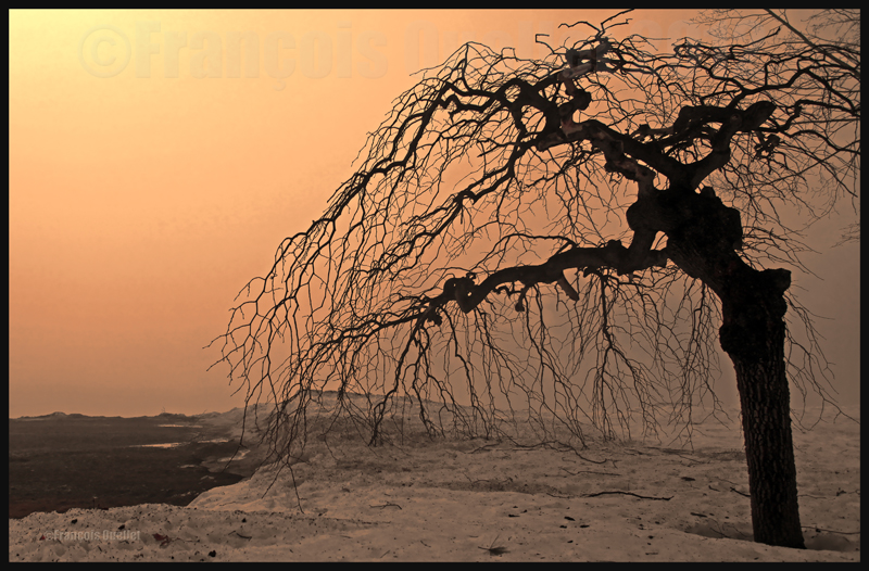
The morning fog
The morning fog offers many opportunities for interesting photos. You can choose an isolated tree and capture the combined effects of the morning sun and fog. Or you may choose a cluster of trees, for a completely different effect. Both photos below were taken in Domaine Cataraqui, Quebec City.
Trees in fog at Domaine Cataraqui, Quebec City 2009
Sun and fog provide for a special atmosphere at the Domaine Cataraqui, Quebec City 2009
A morning fog resulting from a cold cloudless night will persist for hours if there is no wind. The cold morning air, motionless over a slightly hotter stretch of water, creates a fog that will finally disappear just before noon, when the atmosphere has been heated enough. If there had been an overcast sky during the night, chances are that the air over the water would have remained at a higher temperature, preventing the formation of fog.
The opportunities for more interesting photos arise when you witness the first holes in the fog layer.
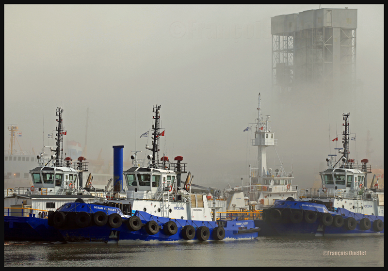
The Ocean tugboats during a dense fog in the Bassin Louise in Quebec (2012).
We can take into account the season to estimate the speed of the diurnal reheating of the lower atmosphere. A morning fog will need more time to dissipate from late autumn to early spring: that leaves more time for the photographer to prepare. The forecasts can announce the disappearance of fog while it will not be the case if, over your sector, there is an invading layer of stratocumulus preventing the morning sun from reaching the ground.
To determine if the fog is going to dissipate as expected or will remain and possibly intensify, watch the difference between the temperature and the dew point on the hourly meteorological observations issued by weather stations near your place of residence. If the temperature and dew point spread increases, the fog is going to lift. If the difference between those two decreases, the fog is going to persist and possibly intensify.
The mist
The mist can be qualified as such when the visibility is superior to ½ mile, but do not exceed 6 miles for an observer on the ground. If the visibility is of ½ mile or less, it is called fog. This photo of the Bic National Park, near Rimouski, shows the interesting effect that the mist adds to a beautiful landscape.
Mist in the Bic National Park, Province of Quebec (2009)
Hot and unstable air in winter
When there is a warm and unstable air advection (about 0 degrees) while winter has already settled, there are good opportunities for photos. A moderately developed cumulus produces significant snow showers and this snow sticks on all the surrounding objects. All that snow would have begun to melt on contact of objects if the latter had had a temperature superior to zero degree. But, the winter being already settled, the snow persists. It gives enough time to capture some souvenirs.
A Quebec City street after a snow shower
The local effects
A photographer might benefit from learning about the meteorological local effects influencing the regions he intends to visit. The local effects are often simple to understand and they repeat themselves regularly, according to wind and season changes. The knowledge of these effects allows the photographer to be ready and position himself even before the phenomenon occurs. It limits the comments like: “If I had known that it would occur, I would have settled down here one hour earlier!“
The local terrain as well as large size bodies of water produce predictable meteorological phenomenon that can be used by a well prepared photographer. It can consist of persistent fog, repetitive snowstorms over a small sector, strong winds, cumuliform clouds alongside the mountain summits, etc. By being positioned at the right place, at the right time, the desired photo can be realized.
A change in the wind direction
A change in the wind direction suddenly increases the opportunities of interesting photos. It might announce the approach of a cold front, a warm front, a sea or land breeze, etc. In the photo below, a bit of fresher air suddenly began crossing the St-Lawrence seaway at the end of the day, thanks to the approach of a weak cold front. The water was still relatively warm and the moisture which was present over the surface became visible due to the cool air supply. The conditions were now ideal for a short-term thin fog, as long as the wind speed would not increase. Just in time for a photo.
The new wood pellets silos in Anse au Foulon in Quebec City en 2014
Familiarization with weather radars
It can be useful to get acquainted with weather radars which, for the needs of photography, remain simple to interpret. Multiple echoes of small dimension with a steep gradient of various colors indicate precipitation resulting from cumuliform clouds. The showers associated with these clouds are often moderated or strong and will be the result of approaching towering cumulus or cumulonimbus (thunderstorms). A towering cumulus presents a dark base and a white summit to the photographer. At sunset, their vertical development can be used to emphasize the last rays of light.
The side of a towering cumulus (TCU) is benefiting from the remaining sunlight over Quebec
Large echo areas of similar colors of low intensity indicate a relatively stable air generally producing steady light rain or drizzle. This should be understood as a possibility of increased humidity limiting the visibility through mist or fog.
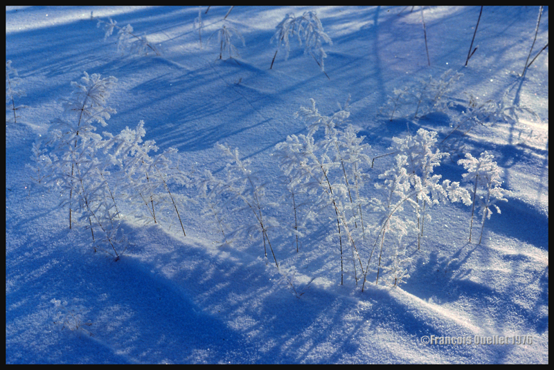
Hoar frost
Hoar frost is a short-term phenomenon. It is thus necessary to capture the scene before the sun melts everything. The photo below shows some small twigs on which hoar frost has settled. It was taken at the beginning of the seventies. Although the quality of the photo is not exceptional, the meteorological phenomenon is well demonstrated.
A combination of snow and hoar frost observed on a Quebec field in 1976.
Forest fires
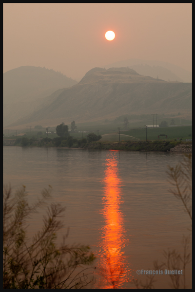
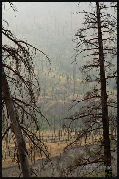
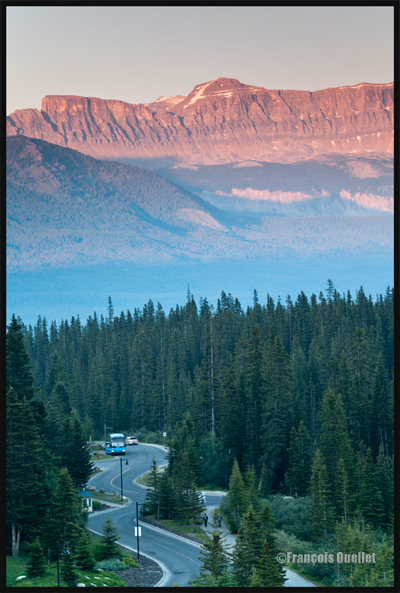
Wishing to make photos of western Canada during summer 2014, I came up against a season where hundreds of forest fires were raging. The smoke was covering some parts of Alberta and British Columbia. Some fires were important enough to require the closure of the sole highway connecting Lake Louise to Jasper. I thus decided to include the effects of those fires in the holiday souvenirs.
A visibility reduced in forest fire smoke allows a photographer to obtain, without special editing, sunsets with interesting colors.
Sunset and smoke from forest fires in Kamloops in 2014
The smoke also produces an effect similar as fog, but a fog which would be impossible to obtain at the end of a summer afternoon while the sun shines and there is a 38 degrees Celsius temperature.
An area near Kamloops, Canada, that was touched by forest fires in 2014
At dusk, the residual smoke is visible near tree tops while the setting sun strikes the mountain side. The effect is of two horizontal lines of complementary colors, blue and orange.
Forest fire smoke and sunset combined in Lake Louise, Alberta en 2014