Categories
Real life stories as a flight service specialist (FSS): Iqaluit FSS

Pilots surprised by the extreme weather prevailing in Iqaluit

The Transport Canada flight service specialists (FSS) in Iqaluit were sometimes amazed by the type of clothing chosen by pilots who were ferrying aircrafts from Europe to America.

Small and mid-size aircrafts required a flight plan including a stopover in Iqaluit, on Baffin Island, since refueling was necessary. One would think that pilots would have prepared themselves for unexpected situations and plan according to the extreme weather conditions prevailing at some of the airports along their route to America.

The FSS staff witnessed, on numerous occasions, small jets experience serious problems while refueling under very cold temperature. While the tanks were being filled up, the tires were deflating progressively.

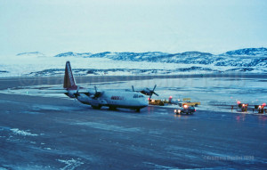
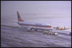
Hapag Lloyd D-AHLO B737-4K5 in its delivery flight in 1989, from Boeing Field (KBFI) to Iqaluit, and then towards Germany. It is being refueled during difficult weather conditions. This type of aircraft did not experience much problem with the cold weather, but it was not the case with smaller business jets

A small delay in the operations and the engines did not start anymore. The pilots got out of their aircraft, wearing only a thin leather jacket and summer shoes. Trying to protect themselves from the bitter cold, they gesticulated while talking with the fuel man who, himself, was wearing a thick Arctic suit that protected him from head to toes.

A thin leather jacket and summer shoes were certainly appropriate for Southern Europe but far from being useful on the apron of an airport where the wind chill factor often varied between -50C and -65C. The aircraft sometimes had to be towed in a hangar in order to be warmed up for hours, if not the night, and the transit fees grew exponentially.

I suppose that a pilot who lived such an experience remembers it today as clearly as the FSS staff, but not for the same reasons. And it is almost certain that he prepared accordingly for the next ferry flight.

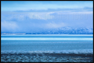
Mountains around Iqaluit, during a nice day when there is still ice in the bay. The blue tones are absolutely magnificent.

For more real life stories as a FSS in Iqaluit, click on the following link: Flight service specialist (FSS) in Iqaluit
Categories
Flight Simulation

Virtual flight and weather engine: PILOT’S FSGRW

FSGRW

FSGRW is a weather generator and it uses downloaded data from the internet to simulate actual real weather all around the world (24,000 + airports).

The program simulates very well what is going on in the atmosphere up to FL520, including the depiction of hurricanes and tropical cyclones.

FSGRW does not come with its own cloud texture packages. Like for ASN(Active Sky Next) or OpusFSI, you must add a texture package from a third party (like REX for example). FSGRW will then use those beautiful textures to represent the downloaded weather from the internet, instead of the old cloud files that were created years ago by Microsoft.

FSGRW was not created to give you access to all kind of fancy options like automatic connections to the weather radar of big airliners. It is a simple but very efficient program that aims at representing the weather accurately.

FSGRW includes some well-known local weather effects.

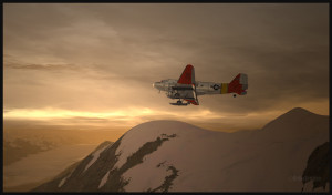
Icefield in sight! A screen capture realized with the following products: FSX, FSGRW, REX, and a combination of Orbx creations. Final editing with a photo editing software (slight corrections only)

FSGRW is compatible with FS2004, FSX, ESP, P3D, Steam and X-Plane. 

FSGRW gives you the possibility to use the actual weather present at one airport and transfer it to another airport. You have access to historic weather through a file-mode option. You may also choose to fly with dynamic or static weather. The weather updates are made every six minutes now that version 027 has been issued.

You can create your own flight plan and weather sequence.

FSGRW can be used through a network.

I own FSGRW and use it in combination with REX texture packages. I am very satisfied of the result. But I don’t doubt that ASN, OpusFSI or REX weather engines can provide excellent results as well. The only thing to remember is that you have to buy a weather engine AND cloud texture packages in order to improve the virtual weather’s visual aspect.

Here is the link: PILOT’S

For more weather engines, click on the following link: Other weather engines

For more articles on flight simulation on my web site, click on the following link : Flight simulation

Categories
Flight Simulation

Virtual flight and weather engine: Active Sky Next (ASN)

Active Sky Next (ASN)

The weather engine ASN (Active Sky Next), like FSGRW, OpusFSI or REX updates the weather by downloading the latest information from the internet. There is also a possibility to use historical data (up to two years back).

ASN, FSGRW and OpusFSI use the default FSX cloud texture sets. So those weather engines can benefit from additional cloud texture sets (from REX for example) for a better visual depiction.

The cloud locations and coverage are accurate as well as realist. Thick overcast layers can be displayed. The cloud transitions are smooth, as well as the vertical variations in temperature, wind speed and wind direction.

Cloud-based effects include in-cloud reduced visibility, related turbulence (in cloud or when entering or exiting a cloud formation), accurate position of precipitation according to the type of clouds and to your position relative to the cloud formation.

Microbursts, wind shears, hail, turbulence as well as updrafts and downdrafts effects are modelled for thunderstorms. There are aural wind shear alerts when flying through a thunderstorm cell: That will nonetheless not be of great help if you attempt to cross a strong thunderstorm as, like in real life, you might not succeed…

You can use the radar to navigate through bad weather since radar and cloud positions are synchronized. The radar shows the intensity of precipitations as well as the echo tops.

Voiced warnings will be triggered when new Airmets and Sigmets are issued. They cover the world and can be viewed on a map. Associated icing and turbulence are added according to the warnings.

In flight, you can receive voiced weather updates through ATIS, FlightWatch or FSS.

ASN corrects the problems sometimes associated with low-level clouds, like inaccurate coverage and wrong position of the clouds, or layers that are really too thin.

Like with other weather engines, there is a flight planning mode. You can enter, import, or build a flight plan, as well as change the flight plan and waypoints at any time before or during a flight.

The weather, airports and navaids are displayed and can be edited, added or erased. The forecasts are available through graphics or text. If, along your route, there is no Metar issued for few hours, the engine will use the forecast to update the weather.

The thermals are modeled using the temperature and surface of terrain.

The wake turbulence trails are visible and, like in real life, are moving with the wind.

ASN does not rely only on interpolation to cover the oceanic areas and other territories where there are few weather stations.

The developers of ASN say that they have created a realistic hurricane simulation based on actual hurricane data. Their program would automatically disregard the ground data that seems incorrect. I cannot comment about the realism of that simulation since I have not tried it yet. But if it is correctly modelled, this function should interest whoever wants to experiment what it is to fly in or near a hurricane.

ASN is compatible with FSX, FSX: SE and the P3D versions up to P3DV4. It can support a multi-monitor setup.

I am not listing all the characteristics of this interesting software since there are always new options added. If you want more details, I provided the link below. Like with all the other weather engines, take the time to see what each has to offer since they have quite different features and spectrum of options.

Here is the link: Active Sky Next

For more weather engines, click on the following link: Other weather engines

For more articles on flight simulation on my web site, click on the following link : Flight simulation

Categories
Flight Simulation

Virtual Flight and Weather Engine: REX (Real Environment XTreme)

REX

REX offers two important elements through its different products: 1) A weather engine that downloads real weather in your computer while replicating the different weather phenomenon, through its REX Essential Plus program and 2) very realistic cloud textures (through its add-ons like Overdrive, Texture Direct, Soft Clouds).

A flight planning mode is also included, as well as numerous options to create specific weather themes that take care of the appearance of the clouds, the quality of the light in the sky, the definition of the sun effects, the different textures and colors of water.

You also have the possibility to choose different runway markings, the sounds associated with thunderstorms and the type of lightning that will illuminate your virtual sky.

REX is compatible with all platforms, including X-Plane.

Here are the REX products, which each play a very different role:

REX Essential Plus: a weather engine and a product that contains cloud textures and multiple options in order to simulate as much as possible the real outside weather for the area you have chosen. The weather engine will soon be renewed with a new addition: REX Weather Direct.

REX Overdrive: adds 12 GB of cloud textures.

REX4 Texture Direct: adds another 16 GB of cloud textures, and a possibility to create complete weather themes according to your preferences, while you still have access to other themes created by all the virtual pilots of the REX community.

REX Soft Clouds: adds volumetric clouds in the lower layer of the atmosphere for a more realistic effect.

REX4 Weather Architect: a program that allows you to create a precise weather system then position it anywhere on the planet. This is not a weather engine: It will not look for new data on internet and download it in your computer.

REX Weather Direct: a soon to be released improved weather engine that will be compatible with DX9, DX10 and DX11 as well as with FSX, FSX: SE (Steam Edition) and P3D.

On virtual flying forums, users seem to have a preference for the Active Sky Next (ASN) weather engine combined with REX cloud textures. This is a good combination, but it’s not the only one that deserves attention: FSGRW together with REX cloud textures do an excellent job (this is the duo that I am using for very precise results). There is also OpusFSI with REX, ASN with ASN2012 (ASN weather engine combined with ASN2012 cloud textures) or even a REX only set of programs (soon to be available REX Weather Direct and REX cloud textures).

This all depends on your priority: the FSGRW simplicity and absolute realism, the facility to use a cockpit camera and the dynamic head movements supported mode of OpusFSI, etc. It is best to read a lot and take the necessary time before jumping to quickly to a conclusion.

Some weather engines might need tweaking or modifications to be compatible with the most recent versions of P3D, if we believe what is written on specialized forums.

Here is the link: REX

For more weather engines, click on the following link: Other weather engines

For more articles on flight simulation on my web site, click on the following link : Flight simulation

Categories
Real life stories as a flight service specialist (FSS): Iqaluit FSS

Iqaluit FSS and the Christmas of a Saab-Scania pilot

(Precedent story: Iqaluit FSS and the Persian Gulf War)

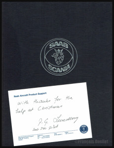
Book and message sent by a Saab-Scania pilot to the Iqaluit flight service specialists

I still have fond memories of a pilot who came up to visit the flight service specialists (FSS) at the Transport Canada flight service station in Iqaluit, in1990, during an icy Christmas evening. This Saab-Scania pilot had arrived from United States and he intended to cross the Atlantic toward Europe.

But the extreme cold prevailing in Iqaluit, on Baffin Island,  had complicated the ground operations. The pilot’s tight schedule as well as the reduced services in effect for the Christmas holidays had given him all sorts of problems. Through his entire ordeal, he kept a professional attitude and we did everything possible to get him out of trouble.

Just before he left the flight service station, he asked us our name and mailing address in Iqaluit. Finally, once all his problems had been taken care of, he took-off from Canada towards his next stopover. Weeks went by and one day, my colleague and I each received a package from Sweden. It was a book about the Saab-Scania story and, inside, there was this little note: “With thanks for the help at Christmas”!

(Next story: A freelance demolition worker in Iqaluit)

For more real life stories as a FSS in Iqaluit, click on the following link: Flight service specialist (FSS) in Iqaluit
Categories
Screen captures

Flight simulation under FSX: The A2A Simulations C182T Skylane

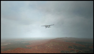
Flying over the Eastern Townships in Quebec under MVFR always represents a problem due to the terrain. Here is a screen capture of a flight from the Quebec international airport to the Sherbrooke airport, to show what a virtual flight looks like during autumn. The terrain has been modelized by Orbx.

A2A Simulations C182T Skylane in the Eastern Townships region in Québec

Here are the first few hills visible but, rapidly, the top of mountains will be obscured in clouds. The downloaded weather is managed by the FSGRW weather engine and the cloud textures are the result of a combination between REX Texture Direct and REX Soft Clouds. A photo software has been used to enhance the contrasts.

The aircraft is a C182T Skylane from A2A Simulations. The similarities between a real aircraft and this virtual aircraft is really unbelievable. The pilot must take care of all corrections, even the gyroscopic precession, otherwise the ADF will indicate the road to follow while the compass sends you in a totally different direction!

Categories
Real life stories as a flight service specialist (FSS): Iqaluit FSS

Iqaluit FSS and the Persian Gulf War

Markair L-382 on a stopover in Iqaluit in 1990

In August 1990, Iraq invaded Kuwait. This invasion was unanimously condemned, even by countries that are traditionally aligned with Iraq. The United Nations reacted by giving Iraq up to January 15th 1991 to withdraw. But Saddam Hussein’s attitude clearly showed that there would be no withdrawal and that he intended to proceed with Kuwait annexation to the Iraqi territory.

Understanding that military force would obviously be necessary, United States (representing a coalition of 34 countries) started preparing for the conflict. Aircraft movements increased and short range military aircrafts that would have to cross the Atlantic used Iqaluit, on Baffin Island, as a stopover before continuing through Greenland, Iceland, Europe and finally the Middle East.

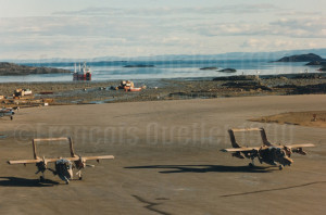
OV-10 Broncos transiting through Iqaluit in 1990 and heading for the Persian Gulf

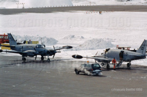
Starting summer 1990, the Iqaluit airport then became one of the mandatory stopovers towards Middle East for some military aircrafts. Soon we could see L-382s carrying large size items and some OV-10 Broncos painted with desert colors landing in Iqaluit. Later on during autumn, other specially equipped aircrafts like the U.S.Army RU-21 Guardrail Common Sensor also made stopovers in Iqaluit.

RU-21 Guardrail Common Sensor on a stopover in Iqaluit in 1990 and heading for the Persian Gulf

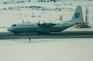
A Southern Air Transport L-382 also landed in Iqaluit. That company was sometimes used by the CIA for its operations.

Southern Air Transport L-382 N908SJ transiting through Iqaluit in 1990

As soon as a flight service specialist (FSS) was not busy with radio communications, he would head toward the briefing counter to receive the military pilots who had come to obtain the mandatory weather and flight planning information that would be used to safely cross the Atlantic.

HF frequencies used for international communications at the local Transport Canada flight service station were really busy. On top of the regular air traffic services normally associated with commercial aircrafts crossing the Atlantic, we were now dealing with the radio communications associated with numerous military cargo aircrafts like the C-5s Galaxy and others.

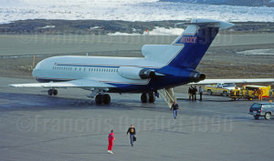
In the two weeks preceding the United Nations ultimatum, between January 1st and 15th 1991, the Iqaluit flight service station recorded a 266 % increase against the same period in 1990 in oceanic traffic transiting through its airport. Flights were mostly related with private or chartered business jets linked to international banks, petroleum companies and military organizations preparing for the events to come. We received, among others, aircraft types like the G1, G2, G3, G4, HS25, DA50, DA90, CL60, C550, LR25 and B-727.

Occidental Petroleum B-727 N10XY on a stopover in Iqaluit in 1990

One night of January 1991, while we were at work, one member of the staff took-off his headphones and calmly told me: “Son, the war has started”.

I will remember that special period since we did not receive a military training but, nonetheless, we witnessed and dealt with the preparation and aircraft movements associated with a major military conflict.

Moreover, for a short period, the Iqaluit airport reverted to the use it had initially been planned and built for in 1942, during the Second World War, which was a base created for short-range military aircrafts heading to Europe.

For more real life stories as a FSS in Iqaluit, click on the following link: Flight service specialist (FSS) in Iqaluit
Categories
Flight Simulation

Flight Simulation: FSGRW and REX together under FSX

Icefield in sight! A screen capture realized with the following products: FSX, FSGRW, REX, and a combination of Orbx creations. Final editing with a photo editing software (slight corrections only)

The screen capture above, titled “Icefield in sight”, represents a virtual flight using the FSX platform. A combination of FSGRW and REX has been used to improve the cloud effects.

As the basic FSX program does not offer a very realistic representation of clouds, it is necessary to get better cloud sets from a third party provider. In the present screen capture, the clouds are a creation of REX, through their Texture Direct and Soft Clouds used in combination.

It is one thing to have access to realistic clouds but you also need a good weather engine. This engine will download real-weather data and, if you wish, will update it every few minutes when you fly.

Many weather engines are available. In the above picture, I used FSGRW (PILOT’S version 1.7, build 29).

To represent the mountains and the icefield, ORBX creations like SAK, Vector and Open LC Canada-Alaska were used. The DC-3 livery is available as a free download from major sites like FlightSim.com or AVSIM .

Last point: when you take a screen capture, it is possible to use a photo editing software (there are many good ones on the market) to slightly improve a particular aspect of the picture. It takes very little effort to learn how to use few basic functions that will enhance your captures.

For more articles on flight simulation on my web site, click on the following link : Flight simulation

Categories
Aviation art

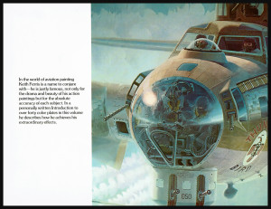
Aviation art: Keith Ferris

As a boy, Keith Ferris lived at Kelly Field, Texas, where his father was a Lieutenant in the U.S. Air Force. He started drawing airplanes from life at age four or five. He used to carve wooden models, initially in balsa then in pine. This proved useful to visualize aircrafts three dimensionally in drawing.

The aviation art of Keith Ferris

Very young, he knew that he would have a military flying career and soon realized that all his flight training manuals were illustrated byJo Kotula, an artist who was self-employed and could make his living out of his art.

Keith tried to learn aeronautical engineering but eventually abandoned it to concentrate on what he liked the most, drawing and painting. He went on to study at the George Washington University and attended the Corcoran School of Art in New York. He became a member of the Society of Illustrators of New York in 1960.

“The Aviation Art of Keith Ferris” is a superb book filled with sketches, amazing drawings and paintings, aviation facts, real aviation stories, advices on how best to represent a scene, quotes from pilots who were actually involved in dogfights. He explains that some of the most demanding challenges for the aviation artist are painting through glass and simulating rotating propellers.

The aviation art of Keith Ferris

Keith Ferris‘s artwork has appeared in the Aviation Week and Space Technology calendar and the Airman Magazine cover, to name a few. Many international companies have used his work for their publicity. Among them, Mitsubishi Aircraft International, General Dynamics and Fairchild Republic Company. His paintings are part of many collections, among which the U.S. Air Force art collection and the National Air and Space Museum of the Smithsonian Institute, Washington D.C.

The book presents paintings of the following type of aircrafts: Lockheed T-33, Boeing P-12, Wright Type A Biplane, Loening OA-1B (amphibian), Spirit of St-Louis, Grumman F-14 Tomcat about to land on an aircraft carrier, B-52 and KC-135 in a refueling operation, the Thunderbirds (F-100), Harvest Reaper F-111, Supermarine Spitfire and German Messerschmitt 109E in a dogfight, Atlas Centaur Space Launch Vehicle cutaway, China Air Force Mig-15 and a F-86 Sabre (the dogfight is over), Fiat C.R.42, F-15 and a Soviet SU-15 in a dogfight, Boeing B-17G Flying Fortress in action, Republic P-47D Thunderbolt, F-4C and F4E Phantoms in action, F-105D and F-105E Thunderchiefs in action, Mitsubishi’s A6M2 Zero-Sen and MU2, Bell 47G, PBY Catalina, Handley Page 0/400, Skylab.

There is also a very interesting story about the steps involved in creating a gigantic B-17 mural (25 feet high by 75 feet wide) for the Smithsonian Institution.

Title: The aviation art of Keith Ferris
Author: Keith Ferris
©1978
Edition: Peacock Press/Bantam Book and edited by Ian Ballantine
ISBN: 0-553-01196-0

Categories
Real life stories as a flight service specialist (FSS): Iqaluit FSS

Two Polish asylum seekers in Iqaluit

(Precedent story: the lady who was robbed before my eyes)

A Trans Ocean Airways DC-8-71 and a Sterling Boeing B-727 in Iqaluit (1989). View from the Iqaluit flight service station.

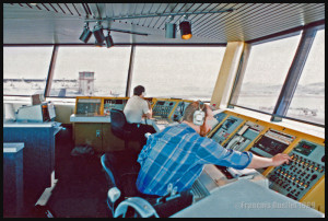
On a 1989 autumn night in Iqaluit, on Baffin Island, Sterling’s Boeing 727 arrived from Europe and parked near the fuel tanks. From the Transport Canada flight service station tower (FSS), we could see the Canadian Customs and RCMP vehicles parked near the airplane, which was unusual. There was something going on as there were many people standing by the rear door of the plane, moving from one vehicle to the other. That was sure a lengthy stopover.

Few days later, on October 2nd 1989, the Journal de Montréal (one of the Montreal newspaper) published the following article: “[my translation] Two Polish citizen who had planned to request asylum in Newfoundland during the technical stopover of their plane on a flight from Gdansk to Vancouver were told on Saturday, by Canadian authorities, that the plane had landed in Canada’s far North”.

The article continues: “[my translation] The two men, whose identity was kept secret, still requested political asylum, said a RCMP police officer from Iqaluit, on Baffin Island in the Arctic. The Polish citizens, who were on a trip to relieve some fishermen on the west coast of Canada, thought they were in St John’s, Newfoundland capital, indicated the policeman in charge, Corporal Gary Asels”.

“The custom officer, using a map, showed them where Iqaluit [in the Nunavut] was located (2100 kilometers north of Montreal). They could not care less, as long as they were in Canada. They were very happy to be here, commented corporal Asels”.

I was told that in order to succeed with their escape from the plane, they had chosen a seat close to the rear stairway of the Boeing 727. They made sure to look like they were sleeping. When the stairway was lowered and the surveillance suspended for a quick moment, the two men just escaped through the stairway and were immediately on Canadian soil.

I am unfortunately unable to confirm today if they have been received as Canadian citizen or if they have been sent back in their country of origin.

(Next story: Iqaluit and the Persian Gulf War)

For more real life stories as a FSS in Iqaluit, click on the following link: Flight service specialist (FSS) in Iqaluit