I have reviewed and edited my list of the Orbx freeware and payware airports, with runway description and airport elevation. It includes most airports that were created up to Halloween 2020.
The addition of airports are based on what Orbx releases on its “Orbx Release Announcements” section. There are airports for Microsoft 2020 (MSFS), X-Plane, P3DV4+, AFS2 and FSX.
Payware airports often come with secondary, smaller virtual airports included in their package. The data is included in the list.
There are several airports included in the older Orbx regions on the west coast of USA that are not shown here. So the list is not perfect, but it does help the flight simmer. For the rest of the planet, the list is pretty accurate.
I have reviewed and edited my list of the Orbx freeware and payware airports, with runway description and airport elevation. It includes most airports that were created as of March 27th, 2020.
I have added many airports based on what Orbx has released since last year on its “OrbxDirect Release Announcements” section. I have also corrected some mistakes that I noted on my list. Every new virtual airport for X-Plane, P3DV4, AFS2 and FSX has been added to this list.
Payware airports often come with secondary, smaller virtual airports included in their package. I reviewed several payware airports and added those smaller airports with their runway description and elevation.
I use the list to plan my virtual flights and find possible challenging situations. The list might not be perfect but it is certainly good enough to be enjoyed by most flight simulation enthusiasts.
You have access to a free download PDF file on my website. Just click on the following secured link.
The complete edition of the Orbx freeware and payware virtual airports, dated June 09 2019, is in the downloadable file below. The runway details and airport elevation is included. It will be updated regularly.
The information in the PDF file is in colour. The airports in black are part of the global pack freewares. The airports in green are freewares that are not part of the global packs. The airports in blue are payware airports.
When a runway is in orange, it means that the length of the runway is 2000 ft or below, and/or the width is 60 ft or below. The water aerodrome are defined by the word “water” in blue. Finally, the elevation of the airport is in red at the end of the runway details.
The third edition of the Orbx freeware and payware virtual airports, dated May 26 2019 is in the downloadable file below. The list is not completed yet, but there is constant progress.
The information in the PDF file is in colour. The airport in black is part of the global pack freeware. The airport in green is a freeware that is not part of the global pack. The airport in blue is a payware airport.
When a runway is in orange, it means that the length of the runway is 2000 ft or below, and/or the width is 60 ft or below. The water aerodrome are defined by the word “water” in blue. Finally, the elevation of the airport is in red at the end of the runway details.
My second edition of the Orbx freeware and payware virtual airports, dated May 19 2019 is in the downloadable file below (the link in green). The list is not completed yet.
The information in the PDF file is in colour. The airport in black is part of the global pack freeware. The airport in green is a freeware that is not part of the global pack. The airport in blue is a payware airport.
When a runway is in orange, it means that the length of the runway is 2000 ft or below, and/or the width is 60 ft or below. The water aerodrome are defined by the word “water” in blue. Finally, the elevation of the airport is in red at the end of the runway details.
The virtual sceneries shown below were used for flight simulation exercises. They are all available online, for sale or free, at ORBX.
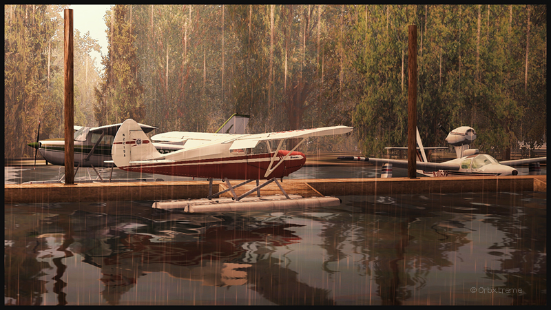
Piper Pacer approaching the dock at Robert’s Lake in Ontario, Canada.
In the scenery above, the red Piper Pacer, which is made by Lionheart Creations Ltd , arrives at a Pier at Robert’s Lake, in Canada. This lake was modelized jointly with the Parry Sound (CNK4) virtual scenery.
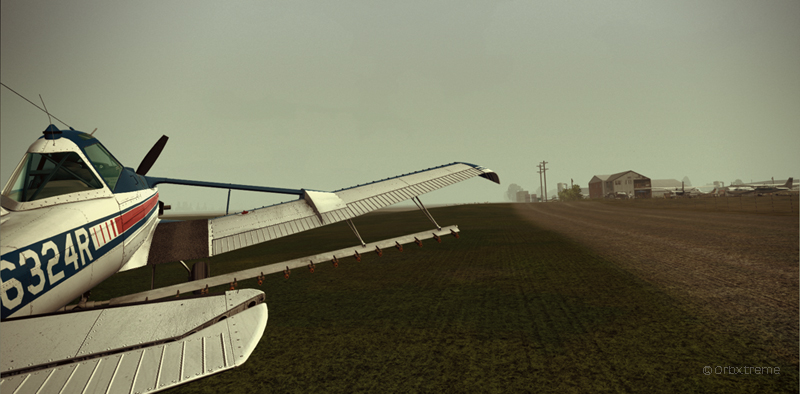
Virtual Cessna C188B Agtruck near Claresholm Industrial Park in Alberta, Canada.
In the picture above, a virtual Cessna C188B Agtruck created by the Alabeo company is parked near the Claresholm Industrial Park (CEJ4), in Canada. The virtual airport is available for free download at ORBX. Who said that nothing in life is free?!
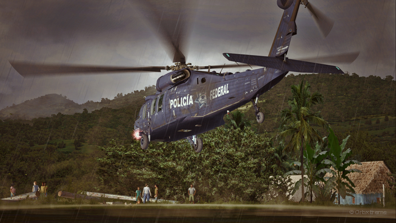
A virtual UH-60L Black Hawk belonging to the Columbian Police Force is hovering in the jungle.
Above, a UH-60L Black Hawk virtual helicopter created by the Cerasim company is flying over the Papua New Guinea territory. It should normally be hovering over Columbia, but the ORBX company has not yet developed very well defined airports for that country. It was more interesting to fly over an area that was already well modelized.
The three screen captures were slightly digitally improved following each virtual flight. The FSX flight simulation platform, although still interesting, is getting a bit old. The original screen captures often benefit from additional digital processing, especially when it comes to posting for the international contest held monthly by the ORBX company.
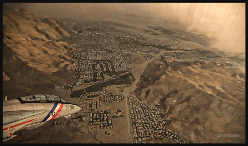
F14 Tomcat inbound to the Palm Springs airport (FSX), USA (KPSP)
Here is an edited screen capture that was added recently in the “flight simulation” section above, under “virtual pictures”. This virtual flight was made using Microsoft Flight Simulator (FSX). The scenery, very well executed by Orbx, represents the Palm Springs region, in United States. It is the most recent addition to the collection of virtual airports available for the California region. The F-14, made by Dino Cattaneo, is a freeware (check the free download links that is provided). This combination of plane and airport is certainly going to please the virtual flight enthousiast!