The third edition of the Orbx freeware and payware virtual airports, dated May 26 2019 is in the downloadable file below. The list is not completed yet, but there is constant progress.
The information in the PDF file is in colour. The airport in black is part of the global pack freeware. The airport in green is a freeware that is not part of the global pack. The airport in blue is a payware airport.
When a runway is in orange, it means that the length of the runway is 2000 ft or below, and/or the width is 60 ft or below. The water aerodrome are defined by the word “water” in blue. Finally, the elevation of the airport is in red at the end of the runway details.
My second edition of the Orbx freeware and payware virtual airports, dated May 19 2019 is in the downloadable file below (the link in green). The list is not completed yet.
The information in the PDF file is in colour. The airport in black is part of the global pack freeware. The airport in green is a freeware that is not part of the global pack. The airport in blue is a payware airport.
When a runway is in orange, it means that the length of the runway is 2000 ft or below, and/or the width is 60 ft or below. The water aerodrome are defined by the word “water” in blue. Finally, the elevation of the airport is in red at the end of the runway details.
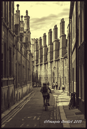
The picture above was taken in 2015 in Cambridge, England. The stark contrasts between the sky and the street combined with the repetitive architectural patterns allowed for an interesting transformation of a color photo into a black and white photo.
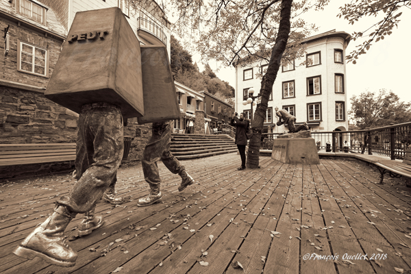
Ephemeral creations are part of the constantly changing portrait of Old Quebec. The public art installations are visible only for a few weeks at a time. The photography lover must stroll through numerous areas of the city in order to find and immortalize an installation before it definitely disappears!
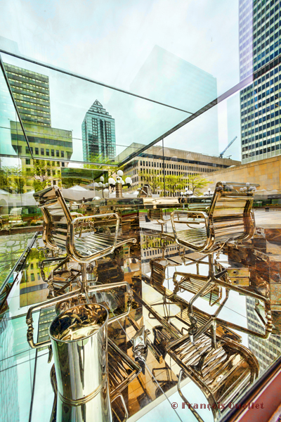
An outside exhibition presenting metal office furniture installed in a glass cage allowed me to show Montreal under an unusual angle. The picture was then digitally treated to give it the desired look.
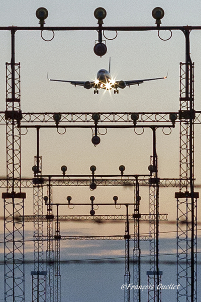
A Boeing 737-800 is on final for runway 05 at the Toronto international airport.
The picture above shows a Boeing 737 800 on approach for runway 05 at the Toronto international airport. I used the precision approach equipment at the threshold of runway 05 to frame the aircraft on approach. A few trials were required to ensure that an aircraft of that size would not seem to be touching the antennas with its wings. At the same time, the rapidly moving Boeing had to stay in focus.
The picture was taken in February by -20C. The ambiant light is always softer at this time of the year. For this hand held photo, I used a Canon EF 50mm f/1.4 USM lens.
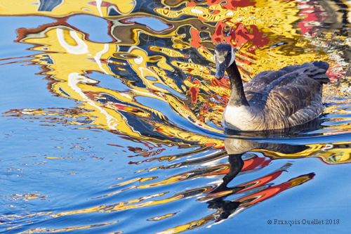
The main subject, in the picture above, can either be the Canada Goose or the bright psychedelic pattern of colours surrounding the bird.
Moments before three geese swam near Victoria’s Fishermen’s Wharf, in British Columbia, the multicolored houses built along the piers were perfectly reflected in the water.
As the geese swam through the reflections, waves and patterns of multiple colours were suddenly created. I chose to take a picture of the last Canada Goose as she benefitted the most from the interesting shapes and colours in the water.
The very bright colours were due to the paint chosen for the houses as well as the direct sunrays striking the houses since the sun that was approching the horizon. The goose is positioned according to the rule of thirds, but this is never mandatory. The small waves in the lower left quadrant gradually lead the eye to the main subject.
The virtual sceneries shown below were used for flight simulation exercises. They are all available online, for sale or free, at ORBX.
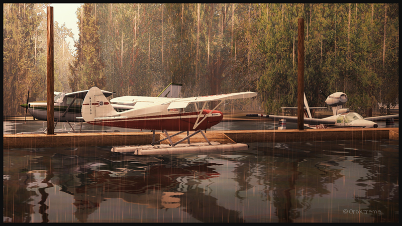
Piper Pacer approaching the dock at Robert’s Lake in Ontario, Canada.
In the scenery above, the red Piper Pacer, which is made by Lionheart Creations Ltd , arrives at a Pier at Robert’s Lake, in Canada. This lake was modelized jointly with the Parry Sound (CNK4) virtual scenery.
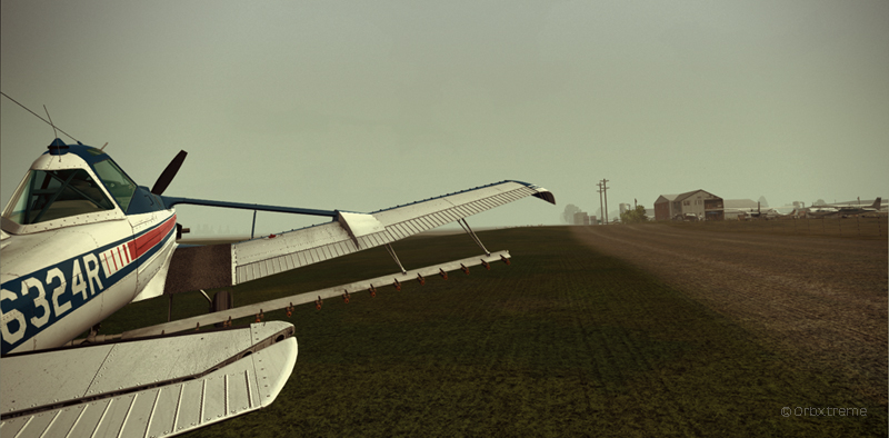
Virtual Cessna C188B Agtruck near Claresholm Industrial Park in Alberta, Canada.
In the picture above, a virtual Cessna C188B Agtruck created by the Alabeo company is parked near the Claresholm Industrial Park (CEJ4), in Canada. The virtual airport is available for free download at ORBX. Who said that nothing in life is free?!
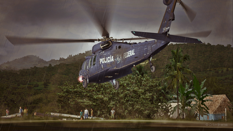
A virtual UH-60L Black Hawk belonging to the Columbian Police Force is hovering in the jungle.
Above, a UH-60L Black Hawk virtual helicopter created by the Cerasim company is flying over the Papua New Guinea territory. It should normally be hovering over Columbia, but the ORBX company has not yet developed very well defined airports for that country. It was more interesting to fly over an area that was already well modelized.
The three screen captures were slightly digitally improved following each virtual flight. The FSX flight simulation platform, although still interesting, is getting a bit old. The original screen captures often benefit from additional digital processing, especially when it comes to posting for the international contest held monthly by the ORBX company.
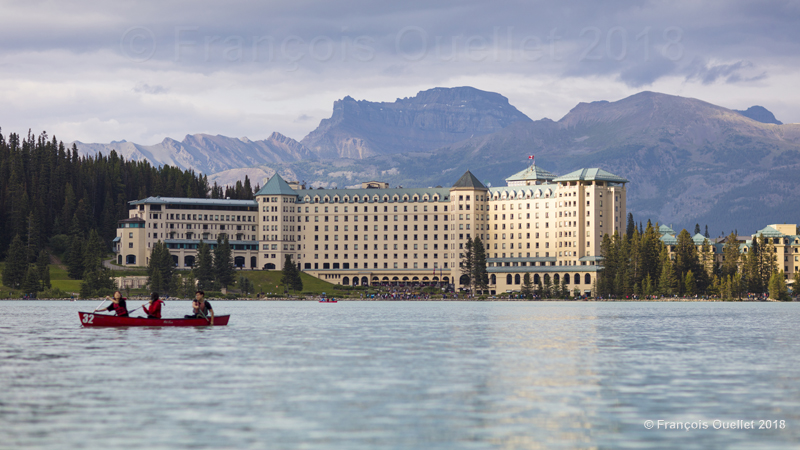
A view of Château Lac Louise and the surrounding mountains.
The picture above shows Château Lake Louise and, in the background, Mount Richardson. Lake Louise is in Alberta but only a few kilometers from British Columbia.
This picture was taken during summer 2018 while several forest fires were raging in western Canada. Luckily for us, the smoke had not yet reached Lake Louise when the picture was taken. A few days later, the visibilty worsened and the air quality in the area degraded considerably.
At the time of the picture, the sky was cloudy and I had to wait for the sky to clear in order for more intense sunrays to light part of Château Lake Louise. This provided a greater contrast between the hotel and the mountains in the background.
I thought it was appropriate to keep the canoe with its passengers to add dynamism to the scenery. The photographic composition was planned so as to include the reflection of the bright part of the hotel on the lake.
In order to make an acceptable picture at this time of the day while sitting in a canoe, I used a Canon EF85mm f/1.2L II USM lens mounted on a Canon 5DSR camera. The outstanding performance of the lens in low light allowed me to keep the ISO at 200, thus limiting the photographic grain.
The shutter speed was adjusted to 1/5000 to compensate for the movement of my canoe and the effect of the wind. It seemed to me that for this particular landscape picture, a 16 x 9 format was better suited than the traditional 3X2 associated with full frame sensors.
Click on the following links for other pictures of Quebec and Canada on my blog.
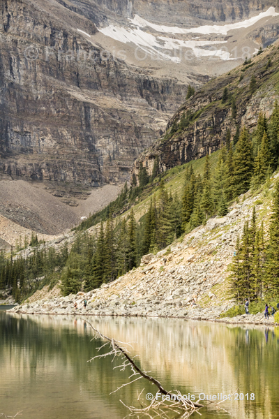
The picture above, taken in 2018, shows a partial view of Lake Agnes. The photographic composition is limited to elements that reinforce the diagonal lines crossing the scenery. In the foreground, the branch reinforces this composition by following the reflection of the rocks in the water.
The limited number of colours in the picture allows for a better view of the diagonal lines in the landscape.
At the extreme right in the foreground are a few people following a pathway along Lake Agnes in order to start the ascent of the Devil’s Thumb (visible in the background) or the more popular Big Beehive.
The picture was taken with a Canon 5DSR camera equipped with a Canon EF 70-200mm f/2.8L IS II USM telephoto lens.
For other pictures of Canada, click on the following links of my blog: